The U.S. Housing Corporation built nearly 300 homes in Bremerton, Wash., during World War I. National Archives
Believe it or not, there was a time when the US government built beautiful homes for working-class Americans to deal with a housing shortage
Eran Ben-Joseph, Massachusetts Institute of Technology (MIT) In 1918, as World War I intensified overseas, the U.S. government embarked on a radical experiment: It quietly became the nation’s largest housing developer, designing and constructing more than 80 new communities across 26 states in just two years. 
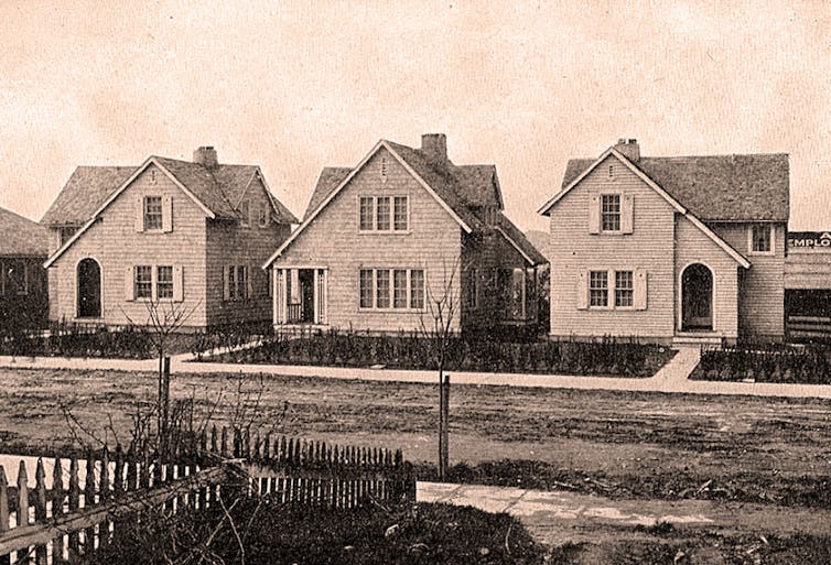
These weren’t hastily erected barracks or rows of identical homes. They were thoughtfully designed neighborhoods, complete with parks, schools, shops and sewer systems. In just two years, this federal initiative provided housing for almost 100,000 people. Few Americans are aware that such an ambitious and comprehensive public housing effort ever took place. Many of the homes are still standing today. But as an urban planning scholar, I believe that this brief historic moment – spearheaded by a shuttered agency called the United States Housing Corporation – offers a revealing lesson on what government-led planning can achieve during a time of national need.
Government mobilization
When the U.S. declared war against Germany in April 1917, federal authorities immediately realized that ship, vehicle and arms manufacturing would be at the heart of the war effort. To meet demand, there needed to be sufficient worker housing near shipyards, munitions plants and steel factories. So on May 16, 1918, Congress authorized President Woodrow Wilson to provide housing and infrastructure for industrial workers vital to national defense. By July, it had appropriated US$100 million – approximately $2.3 billion today – for the effort, with Secretary of Labor William B. Wilson tasked with overseeing it via the U.S. Housing Corporation. Over the course of two years, the agency designed and planned over 80 housing projects. Some developments were small, consisting of a few dozen dwellings. Others approached the size of entire new towns. For example, Cradock, near Norfolk, Virginia, was planned on a 310-acre site, with more than 800 detached homes developed on just 100 of those acres. In Dayton, Ohio, the agency created a 107-acre community that included 175 detached homes and a mix of over 600 semidetached homes and row houses, along with schools, shops, a community center and a park.
Designing ideal communities
Notably, the Housing Corporation was not simply committed to offering shelter. Its architects, planners and engineers aimed to create communities that were not only functional but also livable and beautiful. They drew heavily from Britain’s late-19th century Garden City movement, a planning philosophy that emphasized low-density housing, the integration of open spaces and a balance between built and natural environments.Milton Hill, a neighborhood designed and developed by the United States Housing Corporation in Alton, Ill.National Archives Importantly, instead of simply creating complexes of apartment units, akin to the public housing projects that most Americans associate with government-funded housing, the agency focused on the construction of single-family and small multifamily residential buildings that workers and their families could eventually own. This approach reflected a belief by the policymakers that property ownership could strengthen community responsibility and social stability. During the war, the federal government rented these homes to workers at regulated rates designed to be fair, while covering maintenance costs. After the war, the government began selling the homes – often to the tenants living in them – through affordable installment plans that provided a practical path to ownership.
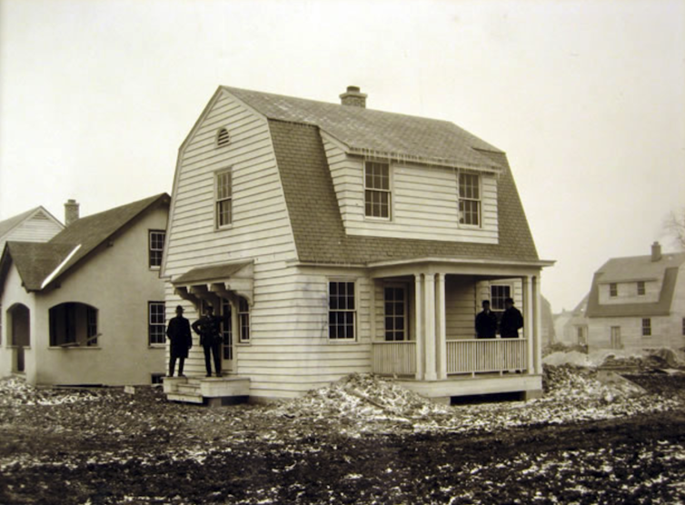
A single-family home in Davenport, Iowa, built by the U.S. Housing Corporation.National Archives Though the scope of the Housing Corporation’s work was national, each planned community took into account regional growth and local architectural styles. Engineers often built streets that adapted to the natural landscape. They spaced houses apart to maximize light, air and privacy, with landscaped yards. No resident lived far from greenery. In Quincy, Massachusetts, for example, the agency built a 22-acre neighborhood with 236 homes designed mostly in a Colonial Revival style to serve the nearby Fore River Shipyard. The development was laid out to maximize views, green space and access to the waterfront, while maintaining density through compact street and lot design. At Mare Island, California, developers located the housing site on a steep hillside near a naval base. Rather than flatten the land, designers worked with the slope, creating winding roads and terraced lots that preserved views and minimized erosion. The result was a 52-acre community with over 200 homes, many of which were designed in the Craftsman style. There was also a school, stores, parks and community centers.
Infrastructure and innovation
Alongside housing construction, the Housing Corporation invested in critical infrastructure. Engineers installed over 649,000 feet of modern sewer and water systems, ensuring that these new communities set a high standard for sanitation and public health. Attention to detail extended inside the homes. Architects experimented with efficient interior layouts and space-saving furnishings, including foldaway beds and built-in kitchenettes. Some of these innovations came from private companies that saw the program as a platform to demonstrate new housing technologies. One company, for example, designed fully furnished studio apartments with furniture that could be rotated or hidden, transforming a space from living room to bedroom to dining room throughout the day. To manage the large scale of this effort, the agency developed and published a set of planning and design standards − the first of their kind in the United States. These manuals covered everything from block configurations and road widths to lighting fixtures and tree-planting guidelines.A single-family home in Bremerton, Wash., built by the U.S. Housing Corporation.National Archives The standards emphasized functionality, aesthetics and long-term livability. Architects and planners who worked for the Housing Corporation carried these ideas into private practice, academia and housing initiatives. Many of the planning norms still used today, such as street hierarchies, lot setbacks and mixed-use zoning, were first tested in these wartime communities. And many of the planners involved in experimental New Deal community projects, such as Greenbelt, Maryland, had worked for or alongside Housing Corporation designers and planners. Their influence is apparent in the layout and design of these communities.
A brief but lasting legacy
With the end of World War I, the political support for federal housing initiatives quickly waned. The Housing Corporation was dissolved by Congress, and many planned projects were never completed. Others were incorporated into existing towns and cities. Yet, many of the neighborhoods built during this period still exist today, integrated in the fabric of the country’s cities and suburbs. Residents in places such as Aberdeen, Maryland; Bremerton, Washington; Bethlehem, Pennsylvania; Watertown, New York; and New Orleans may not even realize that many of the homes in their communities originated from a bold federal housing experiment.
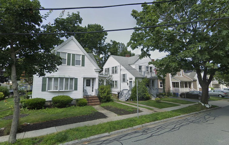
Homes on Lawn Avenue in Quincy, Mass., that were built by the U.S. Housing Corporation.Google Street View The Housing Corporation’s efforts, though brief, showed that large-scale public housing could be thoughtfully designed, community oriented and quickly executed. For a short time, in response to extraordinary circumstances, the U.S. government succeeded in building more than just houses. It constructed entire communities, demonstrating that government has a major role and can lead in finding appropriate, innovative solutions to complex challenges. At a moment when the U.S. once again faces a housing crisis, the legacy of the U.S. Housing Corporation serves as a reminder that bold public action can meet urgent needs. This article is part of a series centered on envisioning ways to deal with the housing crisis.Eran Ben-Joseph, Professor of Landscape Architecture and Urban Planning, Massachusetts Institute of Technology (MIT) This article is republished from The Conversation under a Creative Commons license. Read the original article.
PG&E Donates $1 Million to Local Food Banks to Help Feed Families
PG&E donates $1 million to local food banks across Northern and Central California—equivalent to about 3 million meals—supporting 38 food banks serving 47 counties.
Just in time for the holidays, Pacific Gas and Electric Company (PG&E) announced a $1 million donation to local food banks across Northern and Central California—support aimed at meeting a surge in demand as more families and seniors struggle to put food on the table. According to PG&E, the contribution is expected to provide the equivalent of roughly 3 million meals and will support 38 food banks serving 47 counties within PG&E’s service territory.
A third major food-bank contribution since September
The $1 million gift marks the third food-bank-focused contribution since September from PG&E or The PG&E Corporation Foundation (the PG&E Foundation). Combined, those efforts bring PG&E’s total community food support in 2025 to $2.37 million. PG&E emphasized that the funding for these charitable contributions comes from PG&E shareholders—not customers.
Food banks facing record-breaking demand
Food banks across California are reporting pressure levels not seen since the pandemic. Officials with the California Association of Food Banks say demand has reached record highs, driven in part by an unexpected surge during the federal government shutdown this fall. “California food banks experienced an unexpected surge with the [federal government] shutdown this fall. So, we reached out for help on their behalf and PG&E responded,” said Stacia Levenfeld, Chief Executive Officer of the California Association of Food Banks. “Their $1 million gift to food banks throughout Northern and Central California will have a meaningful impact on the lives of millions of people this holiday season and help food banks continue their critical work in our communities.” PG&E leaders framed the donation as an extension of a longstanding partnership with food bank networks. “We are grateful to help local food banks fulfill their mission during this time of increasing demand, especially as more families and seniors are struggling through the holiday season,” said Carla Peterman, Executive Vice President, Corporate Affairs, PG&E Corporation and Chair of The PG&E Corporation Foundation Board. “Our longstanding partnership with the California Association of Food Banks supports the safety net that is our local food banks.”
Where the 2025 food support has gone
PG&E outlined additional contributions made earlier in the year:
September: The PG&E Foundation awarded $1.12 million to support local food banks, tribal food banks, and senior meal programs.
November: The PG&E Foundation donated $250,000 to the California Association of Food Banks’ Emergency Response Fund.
Equity-focused grant distribution
The California Association of Food Banks notes that while California produces nearly half of the nation’s fruits and vegetables, more than one in five residents still don’t know where their next meal will come from. Food insecurity rates are even higher in many communities of color. PG&E said grant amounts awarded to local organizations will account for county poverty and unemployment levels, using a formula from the California Department of Social Services. The goal: promote equity by directing more support to counties with higher need.
About the PG&E Corporation Foundation and PG&E
The PG&E Corporation Foundation is an independent 501(c)(3) nonprofit organization, separate from PG&E and sponsored by PG&E Corporation. PG&E is a combined natural gas and electric utility serving more than 16 million people across 70,000 square miles in Northern and Central California. More information is available at pge.com and pge.com/news.
Why this matters
As food banks brace for sustained demand beyond the holiday season, large-scale donations like PG&E’s can help stabilize local supply—especially when distributed with an equity lens that targets the counties facing the steepest economic pressures. For families, seniors, and individuals navigating rising costs, the impact is immediate: more meals available now, and stronger community support systems heading into the new year. Community links:
In the 1970s, Lynwood, CA, dreamed of a downtown mall anchored by Montgomery Ward. Decades later, the empty lots told a story of ambition, delay, and renewal.
In the early 1970s, Lynwood, California, dreamed big.
City leaders envisioned a new, modern downtown — a sprawling shopping and auto mall that would bring jobs, shoppers, and a sense of pride back to this small but growing city in the southeast corner of Los Angeles County. At the heart of the plan stood a gleaming new Montgomery Ward department store, which opened around 1973 and promised to anchor a larger commercial center that never fully came.
But for those of us who grew up in Lynwood during that time, the promise never quite materialized.
Instead, we remember acres of empty lots, chain-link fences, and faded “Coming Soon” signs that sat for decades — silent witnesses to a dream deferred.
The Vision That Stalled
In 1973, Lynwood’s Redevelopment Agency launched what it called Project Area A — an ambitious plan to clear and rebuild much of the city’s downtown core. Small businesses and homes were bought out, land was assembled, and the city floated bonds to support new construction.
For a brief moment, it looked as if the plan might work. Montgomery Ward opened its doors, serving as a retail beacon for the area. Yet the rest of the mall — the shops, restaurants, and auto dealerships — never came.
By the mid-1970s, much of downtown had been bulldozed, but little replaced it. And by the time Ward closed its Lynwood location in 1986, the vast lots surrounding it had become symbols of frustration and unfulfilled potential.
What Happened?
Some longtime residents whispered about corruption or backroom deals — the kind of speculation that grows when visible progress stalls.
But newspaper archives and redevelopment records tell a more complex story.
Lynwood’s plans collided with a series of hard realities:
The construction of the Century Freeway (I-105) disrupted neighborhoods and depressed land values. Environmental cleanup and ownership disputes slowed development. Economic shifts in retail — as malls in nearby Downey, South Gate, and Paramount attracted anchor stores — drained the local market. And later, political infighting among city officials made sustained redevelopment almost impossible.
Advertisement
To this day, there’s no public record of proven corruption directly tied to the 1970s mall plan. What did exist was a tangle of bureaucracy, economic change, and missed opportunity — a perfect storm that left Lynwood’s heart half-built and half-forgotten.
Growing Up Among the Vacant Lots
For those of us who were kids in Lynwood during that era, the story is more personal.
We remember the sight of the Montgomery Ward building — modern and hopeful at first, then shuttered and fading by the mid-1980s.
We remember riding bikes past the empty dirt fields that were supposed to become shopping plazas. And we remember the quiet frustration of adults who had believed the city’s promises.
Those empty blocks became our playgrounds — but they also became symbols of the gap between what Lynwood was and what it wanted to be.
A New Chapter: Plaza México and Beyond
By the late 1990s and early 2000s, the dream finally resurfaced in a new form.
Developers transformed the long-idle site into Plaza México, a vibrant commercial and cultural hub that celebrates Mexican and Latin American heritage.
It took nearly 30 years for Lynwood’s downtown to come alive again.
The result is beautiful — but it’s also bittersweet for those who remember how long the land sat empty, and how many local businesses and residents were displaced in pursuit of a dream that took a generation to fulfill.
Advertisement
Looking Back
The story of Lynwood’s lost mall isn’t just about urban planning.
It’s about hope, change, and resilience. It’s about how a community tried to reinvent itself — and how the children who grew up watching that effort still carry its memory.
Sometimes, when I drive through that stretch of Imperial Highway and Long Beach Boulevard, I still imagine what might have been: the bustling mall that never was, and the voices of a neighborhood caught between ambition and uncertainty.
📚 Further Reading
Montgomery Ward will close its Lynwood store. (Jan 3 1986) — Los Angeles Times.
Dive into “The Knowledge,” where curiosity meets clarity. This playlist, in collaboration with STMDailyNews.com, is designed for viewers who value historical accuracy and insightful learning. Our short videos, ranging from 30 seconds to a minute and a half, make complex subjects easy to grasp in no time. Covering everything from historical events to contemporary processes and entertainment, “The Knowledge” bridges the past with the present. In a world where information is abundant yet often misused, our series aims to guide you through the noise, preserving vital knowledge and truths that shape our lives today. Perfect for curious minds eager to discover the ‘why’ and ‘how’ of everything around us. Subscribe and join in as we explore the facts that matter. https://stmdailynews.com/the-knowledge/
Population Density: How Los Angeles Compares to New York and Chicago
How dense are America’s biggest cities? A clear breakdown of population density in Los Angeles, New York City, and Chicago—city limits vs metro areas—and why it matters.
Population Density: How Los Angeles Compares to New York and Chicago
When people think of crowded American cities, New York City usually comes to mind first. Los Angeles, by contrast, is often labeled as “sprawling,” while Chicago is seen as a middle ground. But population density tells a more nuanced story—especially when comparing city proper numbers versus metro-area density.
City Proper: How Dense Are the Cities Themselves?
Looking only at official city boundaries, the differences are stark:
New York City averages about 27,000–28,000 people per square mile, making it by far the most densely populated major city in the United States.
Chicago comes in at roughly 12,000 people per square mile, dense but far more spread out than New York.
Los Angeles, despite being the nation’s second-largest city by population, averages just 8,400–8,500 people per square mile.
This gap reflects development patterns. New York grew upward with dense apartment buildings and extensive transit. Los Angeles expanded outward with single-family neighborhoods and car-oriented planning.
Metro Areas Tell a Different Story
When the lens widens to include surrounding suburbs and commuter communities, the rankings shift:
Los Angeles Metro Area: ~7,000 people per square mile
New York Metro Area: ~5,300 people per square mile
Chicago Metro Area: ~3,500 people per square mile
This surprises many readers. While New York’s core is extremely dense, its metro region stretches across a vast, lower-density area spanning parts of New York, New Jersey, and Pennsylvania. Los Angeles, on the other hand, has a metro region that is more consistently built-up, with fewer truly rural gaps.
Why Density Feels Different in Each City
Population density doesn’t always match perception:
New York feels crowded because density is concentrated vertically and transit funnels millions into compact areas.
Los Angeles feels congested not because of extreme density, but because people are spread out and heavily reliant on cars.
Chicago balances both, with dense neighborhoods near the core and more traditional suburban sprawl outward.
For cities like Los Angeles—now reinvesting in rail, buses, and transit-oriented development—understanding density is critical. As coverage on LA Metro and urban revival continues, these numbers explain why transit challenges in Southern California differ so sharply from those in New York or Chicago.
The Big Picture
Most dense city: New York City
Most dense metro area: Los Angeles
Most balanced: Chicago
Density isn’t just about how many people live in a place—it’s about how they live, move, and interact with the city around them.
Further Reading: Population Density & Urban Development
Dive into “The Knowledge,” where curiosity meets clarity. This playlist, in collaboration with STMDailyNews.com, is designed for viewers who value historical accuracy and insightful learning. Our short videos, ranging from 30 seconds to a minute and a half, make complex subjects easy to grasp in no time. Covering everything from historical events to contemporary processes and entertainment, “The Knowledge” bridges the past with the present. In a world where information is abundant yet often misused, our series aims to guide you through the noise, preserving vital knowledge and truths that shape our lives today. Perfect for curious minds eager to discover the ‘why’ and ‘how’ of everything around us. Subscribe and join in as we explore the facts that matter. https://stmdailynews.com/the-knowledge/