

News
Listening for the right radio signals could be an effective way to track small drones
Unidentified drone sightings near sensitive U.S. locations raise public concern. Challenges exist in tracking these drones, necessitating better detection methods and potential regulatory changes for airspace management.
Iain Boyd, University of Colorado Boulder
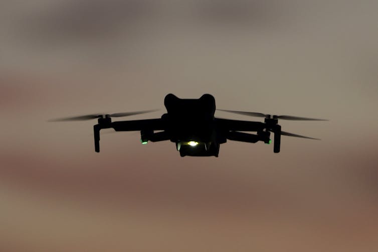
The recent spate of unidentified drone sightings in the U.S., including some near sensitive locations such as airports and military installations, has caused significant public concern.
Some of this recent increase in activity may be related to a September 2023 change in U.S. Federal Aviation Administration regulations that now allow drone operators to fly at night. But most of the sightings are likely airplanes or helicopters rather than drones.
The inability of the U.S. government to definitively identify the aircraft in the recent incidents, however, has some people wondering, why can’t they?
I am an engineer who studies defense systems. I see radio frequency sensors as a promising approach to detecting, tracking and identifying drones, not least because drone detectors based on the technology are already available. But I also see challenges to using the detectors to comprehensively spot drones flying over American communities.
How drones are controlled
Operators communicate with drones from a distance using radio frequency signals. Radio frequency signals are widely used in everyday life such as in garage door openers, car key fobs and, of course, radios. Because the radio spectrum is used for so many different purposes, it is carefully regulated by the Federal Communications Commission.
Drone communications are only allowed in narrow bands around specific frequencies such as at 5 gigahertz. Each make and model of a drone uses unique communication protocols coded within the radio frequency signals to interpret instructions from an operator and to send data back to them. In this way, a drone pilot can instruct the drone to execute a flight maneuver, and the drone can inform the pilot where it is and how fast it is flying.
Identifying drones by radio signals
Radio frequency sensors can listen in to the well-known drone frequencies to detect communication protocols that are specific to each particular drone model. In a sense, these radio frequency signals represent a unique fingerprint of each type of drone.
In the best-case scenario, authorities can use the radio frequency signals to determine the drone’s location, range, speed and flight direction. These radio frequency devices are called passive sensors because they simply listen out for and receive signals without taking any active steps. The typical range limit for detecting signals is about 3 miles (4.8 kilometers) from the source.
These sensors do not represent advanced technology, and they are readily available. So, why haven’t authorities made wider use of them? https://www.youtube.com/embed/9yFzdpEqQCs?wmode=transparent&start=0 Drones were all the buzz in the Northeast at the end of 2024.
Challenges to using radio frequency sensors
While the monitoring of radio frequency signals is a promising approach to detecting and identifying drones, there are several challenges to doing so.
First, it’s only possible for a sensor to obtain detailed information on drones that the sensor knows the communication protocols for. Getting sensors that can detect a wide range of drones will require coordination between all drone manufacturers and some central registration entity.
In the absence of information that makes it possible to decode the radio frequency signals, all that can be inferred about a drone is a rough idea of its location and direction. This situation can be improved by deploying multiple sensors and coordinating their information.
Second, the detection approach works best in “quiet” radio frequency environments where there are no buildings, machinery or people. It’s not easy to confidently attribute the unique source of a radio frequency signal in urban settings and other cluttered environments. Radio frequency signals bounce off all solid surfaces, making it difficult to be sure where the original signal came from. Again, the use of multiple sensors around a particular location, and careful placement of those sensors, can help to alleviate this issue.
Third, a major part of the concern over the inability to detect and identify drones is that they may be operated by criminals or terrorists. If drone operators with malicious intent know that an area targeted for a drone operation is being monitored by radio frequency sensors, they may develop effective countermeasures. For example, they may use signal frequencies that lie outside the FCC-regulated parameters, and communication protocols that have not been registered. An even more effective countermeasure is to preprogram the flight path of a drone to completely avoid the use of any radio frequency communications between the operator and the drone.
Finally, widespread deployment of radio frequency sensors for tracking drones would be logistically complicated and financially expensive. There are likely thousands of locations in the U.S. alone that might require protection from hostile drone attacks. The cost of deploying a fully effective drone detection system would be significant.
There are other means of detecting drones, including radar systems and networks of acoustic sensors, which listen for the unique sounds drones generate. But radar systems are relatively expensive, and acoustic drone detection is a new technology.
The way forward
It was almost guaranteed that at some point the problem of unidentified drones would arise. People are operating drones more and more in regions of the airspace that have previously been very sparsely populated.
Perhaps the recent concerns over drone sightings are a wake-up call. The airspace is only going to become much more congested in the coming years as more consumers buy drones, drones are used for more commercial purposes, and air-taxis come into use. There’s only so much that drone detection technologies can do, and it might become necessary for the FAA to tighten regulation of the nation’s airspace by, for example, requiring drone operators to submit detailed flight plans.
In the meantime, don’t be too quick to assume those blinking lights you see in the night sky are drones.
Iain Boyd, Director of the Center for National Security Initiatives and Professor of Aerospace Engineering Sciences, University of Colorado Boulder
This article is republished from The Conversation under a Creative Commons license. Read the original article.


Last Updated on April 2, 2026 by Daily News Staff
🕒 [UPDATE] Orion Performs Translunar Injection Burn
The spacecraft has completed its critical engine burn, sending Artemis II on a trajectory toward the Moon. This marks the official start of its deep space journey.

Artemis II Successfully Launches
CAPE CANAVERAL, Fla. — NASA has successfully launched its Artemis II mission, marking the first crewed journey toward the Moon in more than 50 years.
The powerful Space Launch System (SLS) rocket lifted off from Kennedy Space Center on April 1, carrying four astronauts on a 10-day mission around the Moon and back.
On board are Commander Reid Wiseman, Pilot Victor Glover, Mission Specialist Christina Koch, and Canadian astronaut Jeremy Hansen. The mission is already being hailed as a major milestone in NASA’s effort to return humans to deep space.
Shortly after liftoff, the Orion spacecraft successfully reached orbit and deployed its solar arrays, beginning its journey that will eventually send the crew on a translunar trajectory toward the Moon. 
Artemis II is a lunar flyby mission, meaning astronauts will not land but will travel farther from Earth than any human mission in decades while testing critical systems needed for future landings.
The mission also marks several historic firsts, including the first woman and the first person of color—Victor Glover—to travel into lunar space.
NASA says the mission is a key step toward future lunar landings and long-term plans to establish a human presence on the Moon later this decade.
🛰️ Artemis II Mission Timeline
The 10-day Artemis II mission follows a carefully planned trajectory from Earth to the Moon and back:
- Day 1: Launch and Earth orbit
- Day 1–2: Translunar injection burn
- Days 2–4: Deep space travel
- Days 4–5: Lunar flyby
- Days 5–8: Return to Earth
- Days 9–10: Reentry and splashdown
For official updates and in-depth mission details, visit the following trusted sources:
- NASA: Artemis II Mission Overview
- NASA Artemis Program (Return to the Moon)
- Orion Spacecraft – Mission Details
- Space Launch System (SLS) Rocket Overview
- Kennedy Space Center – Launch Operations
- Watch NASA Live Coverage and Replays
🧾 Sources
- NASA official launch coverage and mission updates
- NASA Artemis II press materials and briefings
- NASA Kennedy Space Center launch operations updates
Stay with STM Daily News for live updates on Artemis II.
Travel Advisory
Traveling to Mexico this spring? Here’s what to know about current advisories
Traveling to Mexico this spring? Visitors should be aware of state-specific travel advisories, as safety concerns in one region do not affect major resort areas like Cancun and Los Cabos, currently rated Level 2, which encourages increased caution. Monitoring official updates is essential for informed travel decisions amidst evolving conditions.
Last Updated on March 30, 2026 by Daily News Staff
Traveling to Mexico this spring? Here’s what to know about current advisories
(Tiffany Miller for ALG Vacations) For some travelers counting down to spring break, recent headlines about violence in parts of Mexico have sparked a new question: Should I cancel my trip? Travel advisors say they are seeing a surge in calls and emails from clients trying to determine whether developments in one region affect major resort areas elsewhere.
The questions follow several days of unrest in parts of Mexico after security operations targeting organized crime leaders prompted temporary flight disruptions and shelter-in-place guidance for U.S. government personnel in areas including Puerto Vallarta and Guadalajara. In this article, ALG Vacations explains what current travel advisories mean for spring break travelers heading to Mexico.
The U.S. State Department evaluates Mexico state by state, not as a single destination, and advisory levels vary by region. Many major beach destinations, including Cancun, Riviera Maya, Tulum and Los Cabos, are currently under a Level 2 advisory, which encourages travelers to exercise increased caution. It does not discourage travel.
Part of the confusion stems from geography. Puerto Vallarta, on the Pacific coast, is roughly 1,300 miles from Cancun and the Riviera Maya on the Caribbean side, about the distance between New York and Miami. Because advisories are assigned state by state, developments in one region do not automatically alter another.
In recent days, that uncertainty has translated into additional inquiries about whether specific resort areas are experiencing disruptions. U.S. Embassy security alerts issued this week indicate that temporary shelter-in-place guidance affecting Puerto Vallarta was lifted and that flight operations resumed. The advisory level for the Mexican state of Quintana Roo remains unchanged.
Some clients are asking about alternatives, advisors say, but many are continuing with their plans after reviewing official updates. Travel patterns often shift in response to breaking headlines, they add, before stabilizing as clearer information becomes available.
The State Department assigns travel advisories on a four-tier scale ranging from Level 1, exercise normal precautions, to Level 4, do not travel. While Level 2 encourages increased awareness, Level 3 and Level 4 carry stronger language discouraging or restricting travel.
Advisories are reviewed regularly and can be updated as conditions evolve. The State Department’s Mexico advisory page breaks down conditions by state, reflecting the country’s federal structure rather than issuing a single national designation. Travelers can also enroll in the State Department’s Smart Traveler Enrollment Program, which provides real-time security updates and allows U.S. officials to contact citizens in an emergency.
Embassy notices state that airports, hotels and tourism services in Quintana Roo are operating normally. Security conditions across Mexico vary widely by state, with some regions carrying higher advisories and others designated Level 1. Most destinations popular with U.S. travelers are currently classified as Level 2.
As spring break approaches, advisors say informed decision-making depends on reviewing the advisories assigned to a specific destination and monitoring official updates, rather than reacting to national headlines alone. Travel decisions ultimately depend on individual comfort levels, they add, but advisory levels are assigned regionally and should be evaluated accordingly.
Photo courtesy of Shutterstock

SOURCE:
Welcome to the Consumer Corner section of STM Daily News, your ultimate destination for savvy shopping and informed decision-making! Dive into a treasure trove of insights and reviews covering everything from the hottest toys that spark joy in your little ones to the latest electronic gadgets that simplify your life. Explore our comprehensive guides on stylish home furnishings, discover smart tips for buying a home or enhancing your living space with creative improvement ideas, and get the lowdown on the best cars through our detailed auto reviews. Whether you’re making a major purchase or simply seeking inspiration, the Consumer Corner is here to empower you every step of the way—unlock the keys to becoming a smarter consumer today!
Community
McDonald’s First Job Confessional Turns Career Stories Into Free Meal Opportunity
McDonald’s is launching First Job Confessional, a campaign inviting fans to share first job stories for a chance to receive a $15 gift card in select cities.

First Job Confessional
McDonald’s is putting first jobs in the spotlight with a new campaign that asks fans to share the real-world skills they gained early in their working lives. Launched on National Employee Appreciation Day, the brand’s First Job Confessional invites people to reflect on how those first roles helped shape their careers — and, in some cases, earn a free meal in the process.
The campaign is built around a simple idea: first jobs often teach lasting skills that deserve more recognition. Whether someone learned problem-solving while babysitting, communication during a lunch rush, or teamwork behind a counter, McDonald’s is framing those experiences as valuable career foundations. The company says those are the same kinds of skills employers continue to prioritize as workplace demands evolve.

How the First Job Confessional Works
In select cities, McDonald’s is setting up confessional booths designed to look like ordering kiosks. But instead of placing a meal order, participants can record a story about their first job and the skills they picked up along the way. Those who take part in person will have the opportunity to receive a $15 McDonald’s gift card, while supplies last.
Fans who cannot attend in person can still join online by posting their stories using #FirstJobConfessional. McDonald’s says selected videos may also be featured on its YouTube channel, extending the campaign beyond the live events.
External Related Links
- McDonald’s corporate article: McDonald’s is Asking Fans to Get Real About Their First Job Skills in Exchange for Free Meals
- McDonald’s 1 in 8: First Job Confessional
- McDonald’s 1 in 8 home page
- Marketing Dive coverage of the campaign
- Parade coverage of the First Job Confessional tour
Source Links
- Original PRNewswire press release from McDonald’s USA, LLC
- McDonald’s official corporate story
- McDonald’s 1 in 8 First Job Confessional page
- McDonald’s 1 in 8 official website
The Bridge is a section of the STM Daily News Blog meant for diversity, offering real news stories about bona fide community efforts to perpetuate a greater good. The purpose of The Bridge is to connect the divides that separate us, fostering understanding and empathy among different groups. By highlighting positive initiatives and inspirational actions, The Bridge aims to create a sense of unity and shared purpose. This section brings to light stories of individuals and organizations working tirelessly to promote inclusivity, equality, and mutual respect. Through these narratives, readers are encouraged to appreciate the richness of diverse perspectives and to participate actively in building stronger, more cohesive communities.
https://stmdailynews.com/the-bridge


