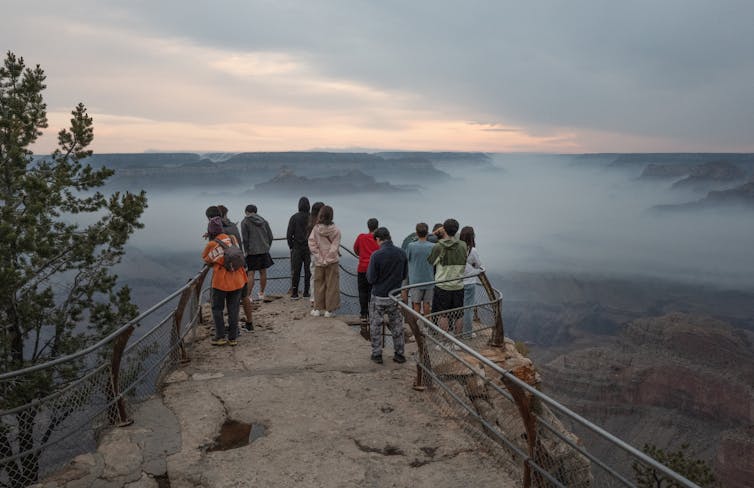
Tourists watch smoke from the Dragon Bravo wildfire float through the Grand Canyon. Scott Olson/Getty Images
Grand Canyon’s Dragon Bravo megafire shows the growing wildfire threat to water systems
Faith Kearns, Arizona State University As wildfire crews battled the Dragon Bravo Fire on the Grand Canyon’s North Rim in July 2025, the air turned toxic. A chlorine gas leak had erupted from the park’s water treatment facility as the building burned, forcing firefighters to pull back. The water treatment facility is part of a system that draws water from a fragile spring. It’s the only water source and system for the park facilities on both rims, including visitor lodging and park service housing. The fire also damaged some of the area’s water pipes and equipment, leaving fire crews to rely on a fleet of large water trucks to haul in water and raising concerns about contamination risks to the water system itself. By mid-August, Dragon Bravo was a “megafire,” having burned over 140,000 acres, and was one of the largest fires in Arizona history. It had destroyed more than 70 structures, including the iconic Grand Canyon Lodge, and sent smoke across the region.A National Park Service worker assesses a split in an exposed section of the Grand Canyon’s fragile water lines in 2014. The water pipeline, installed in the mid-1960s, feeds water from Roaring Springs, located approximately 3,500 feet below the North Rim.Grand Canyon National Park via Flickr Wildfires like this are increasingly affecting water supplies across the U.S. and creating a compounding crisis that experts in water, utilities and emergency management are only beginning to wrestle with.
A pattern across the West
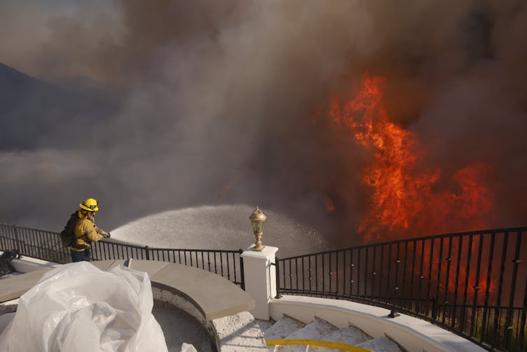
Before 2017, when the Tubbs Fire burned through neighborhoods on the edge of Santa Rosa, California, most research on the nexus of wildfire and water had focused on issues such as drought and how climate change effects ecosystems. The Tubbs Fire destroyed thousands of buildings and also melted plastic water pipes. After the fire, a resident’s complaint about the taste and odor of tap water led to the discovery that the fire’s damage had introduced contaminants including benzene, a carcinogen, into parts of the public water system. It quickly became obvious that the damage discovered at the Tubbs Fire was not unique. Similar damage and pollutants were discovered in another California water system after the 2018 Camp Fire destroyed much of Paradise, a town of over 25,000 people. The list of incidents goes on. In southern Oregon, the 2020 Almeda Fire damaged water pipes in buildings, leaving water to flow freely. That contributed to low system pressure just when people fighting the fire needed the water.Water meters and pipes are vulnerable to damage during a fire.Andrew Whelton/Purdue University, CC BY In Colorado, the 2021 Marshall Fire burned through urban water lines, damaging six public drinking-water systems along with more than 1,000 structures in the Boulder suburbs. All six systems lost power, which in some cases led to a loss of water pressure, hampering firefighting. As firefighters worked on the Marshall Fire, water system operators raced to keep water flowing and contaminants from being transported into the water systems. But tests still detected chemical contamination, including benzene, in parts of the systems a few weeks later. Then, in January 2025, the Los Angeles fires supercharged concerns about water and wildfire. As firefighters raced to put out multiple fires, hydrants ran dry in some parts of the region, while others at higher elevations depressurized. Ultimately, over 16,000 structures were damaged, leading to insured losses estimated to be as high as US$45 billion.Water supplies are crucial to fighting fires. In cities, fire crews like this one battling the Palisades Fire in Los Angeles in January 2025 can often rely on hydrants. But water systems can lose pressure and potentially the power to run their pumps during fires.AP Photo/Etienne Laurent Water infrastructure is not merely collateral damage during wildfires – it is now a central concern. It also raises the question: What can residents, first responders and decision-makers reasonably expect from water systems that weren’t designed with today’s disasters in mind?
Addressing the growing fire and water challenge
While no two water systems or fires are the same, nearly every water system component, ranging from storage tanks to pipelines to treatment plants, is susceptible to damage. The Grand Canyon’s Roaring Springs system exemplifies the complexity and fragility of older systems. It supplies water to both rims of the park through a decades-old network of gravity-fed pipes and tunnels and includes the water treatment facility where firefighters were forced to retreat because of the chlorine leak. Many water systems have vulnerable points within or near flammable wildlands, such as exposed pump houses that are crucial for pulling water from lower elevations to where it is needed.A stand pipe at Zorthian Ranch in Altadena, Calif., failed during the January 2025 fire there, making it even more difficult for Alan Zorthian to fight the flames sweeping across his property. He used a pump drawing water from a swimming pool to try to fight the flames, but numerous structures were destroyed.Myung J. Chun/Los Angeles Times via Getty Images In addition, hazardous materials such as chlorine or ammonia may be stored on-site and require special considerations in high fire risk areas. Staff capacity is often limited; some small utilities depend on a single operator, and budgets may be too constrained to modernize aging infrastructure or implement fire mitigation measures. As climate change intensifies wildfire seasons, these vulnerabilities can become disaster risks that require making water infrastructure a more integral part of fighting and preparing for wildfires.
Prioritizing fire-resistant construction, better shielding of chemicals and, in some cases, decentralizing water systems can help protect critical facilities, particularly in high-risk zones. Having backup power supplies, mobile treatment systems and alternate water sources are essential to provide more security in the face of a wildfire.
Emergency command protocols and interagency coordination are most effective when they include water utilities as essential partners in all phases of emergency response, from planning to response to recovery. Fire crews and water operators can also benefit from joint training in emergency response, especially when system failure could hinder firefighting itself.
Longer term, protecting upstream watersheds from severe fire by thinning forests and using controlled burns, along with erosion control measures, can help maintain water quality and reduce water pollution in the aftermath of fires.
Smaller and more isolated systems, particularly in tribal or low-income communities, often need assistance to plan or implement new measures. These systems may require technical assistance, and regional support hubs could support communities with additional resources, including personnel and equipment, so they can respond quickly when crises strike.
Looking ahead
The Dragon Bravo Fire isn’t just a wildfire story, it’s also a water story, and it signals a larger, emerging challenge across the West. As fire seasons expand in size and complexity, the overlap between fire and water will only grow. The Grand Canyon fire offers a stark illustration of how wildfire can escalate into a multifaceted infrastructure crisis: Fire can damage water infrastructure, which in turn limits firefighting capabilities and stresses water supplies. The question is not whether this will happen again. It’s how prepared communities will be when it does. Faith Kearns, Scientist and Director of Research Communication for the Arizona Water Innovation Initiative, Arizona State University This article is republished from The Conversation under a Creative Commons license. Read the original article.
Traveling to Mexico this spring? Here’s what to know about current advisories
Traveling to Mexico this spring? Visitors should be aware of state-specific travel advisories, as safety concerns in one region do not affect major resort areas like Cancun and Los Cabos, currently rated Level 2, which encourages increased caution. Monitoring official updates is essential for informed travel decisions amidst evolving conditions.
Traveling to Mexico this spring? Here’s what to know about current advisories
(Tiffany Miller for ALG Vacations) For some travelers counting down to spring break, recent headlines about violence in parts of Mexico have sparked a new question: Should I cancel my trip? Travel advisors say they are seeing a surge in calls and emails from clients trying to determine whether developments in one region affect major resort areas elsewhere.
The questions follow several days of unrest in parts of Mexico after security operations targeting organized crime leaders prompted temporary flight disruptions and shelter-in-place guidance for U.S. government personnel in areas including Puerto Vallarta and Guadalajara. In this article, ALG Vacations explains what current travel advisories mean for spring break travelers heading to Mexico.
The U.S. State Department evaluates Mexico state by state, not as a single destination, and advisory levels vary by region. Many major beach destinations, including Cancun, Riviera Maya, Tulum and Los Cabos, are currently under a Level 2 advisory, which encourages travelers to exercise increased caution. It does not discourage travel.
Part of the confusion stems from geography. Puerto Vallarta, on the Pacific coast, is roughly 1,300 miles from Cancun and the Riviera Maya on the Caribbean side, about the distance between New York and Miami. Because advisories are assigned state by state, developments in one region do not automatically alter another.
In recent days, that uncertainty has translated into additional inquiries about whether specific resort areas are experiencing disruptions. U.S. Embassy security alerts issued this week indicate that temporary shelter-in-place guidance affecting Puerto Vallarta was lifted and that flight operations resumed. The advisory level for the Mexican state of Quintana Roo remains unchanged.
Some clients are asking about alternatives, advisors say, but many are continuing with their plans after reviewing official updates. Travel patterns often shift in response to breaking headlines, they add, before stabilizing as clearer information becomes available.
The State Department assigns travel advisories on a four-tier scale ranging from Level 1, exercise normal precautions, to Level 4, do not travel. While Level 2 encourages increased awareness, Level 3 and Level 4 carry stronger language discouraging or restricting travel.
Advisories are reviewed regularly and can be updated as conditions evolve. The State Department’s Mexico advisory page breaks down conditions by state, reflecting the country’s federal structure rather than issuing a single national designation. Travelers can also enroll in the State Department’s Smart Traveler Enrollment Program, which provides real-time security updates and allows U.S. officials to contact citizens in an emergency.
Advertisement
Embassy notices state that airports, hotels and tourism services in Quintana Roo are operating normally. Security conditions across Mexico vary widely by state, with some regions carrying higher advisories and others designated Level 1. Most destinations popular with U.S. travelers are currently classified as Level 2.
As spring break approaches, advisors say informed decision-making depends on reviewing the advisories assigned to a specific destination and monitoring official updates, rather than reacting to national headlines alone. Travel decisions ultimately depend on individual comfort levels, they add, but advisory levels are assigned regionally and should be evaluated accordingly.
Welcome to the Consumer Corner section of STM Daily News, your ultimate destination for savvy shopping and informed decision-making! Dive into a treasure trove of insights and reviews covering everything from the hottest toys that spark joy in your little ones to the latest electronic gadgets that simplify your life. Explore our comprehensive guides on stylish home furnishings, discover smart tips for buying a home or enhancing your living space with creative improvement ideas, and get the lowdown on the best cars through our detailed auto reviews. Whether you’re making a major purchase or simply seeking inspiration, the Consumer Corner is here to empower you every step of the way—unlock the keys to becoming a smarter consumer today!
McDonald’s First Job Confessional Turns Career Stories Into Free Meal Opportunity
McDonald’s is launching First Job Confessional, a campaign inviting fans to share first job stories for a chance to receive a $15 gift card in select cities.
McDonald’s is Asking Fans to Get Real About Their First Job Skills in Exchange for Free Meals
First Job Confessional
McDonald’s is putting first jobs in the spotlight with a new campaign that asks fans to share the real-world skills they gained early in their working lives. Launched on National Employee Appreciation Day, the brand’s First Job Confessional invites people to reflect on how those first roles helped shape their careers — and, in some cases, earn a free meal in the process.
The campaign is built around a simple idea: first jobs often teach lasting skills that deserve more recognition. Whether someone learned problem-solving while babysitting, communication during a lunch rush, or teamwork behind a counter, McDonald’s is framing those experiences as valuable career foundations. The company says those are the same kinds of skills employers continue to prioritize as workplace demands evolve.
McDonald’s is Asking Fans to Get Real About Their First Job Skills in Exchange for Free Meals
How the First Job Confessional Works
In select cities, McDonald’s is setting up confessional booths designed to look like ordering kiosks. But instead of placing a meal order, participants can record a story about their first job and the skills they picked up along the way. Those who take part in person will have the opportunity to receive a $15 McDonald’s gift card, while supplies last.
Fans who cannot attend in person can still join online by posting their stories using #FirstJobConfessional. McDonald’s says selected videos may also be featured on its YouTube channel, extending the campaign beyond the live events.
The Bridge is a section of the STM Daily News Blog meant for diversity, offering real news stories about bona fide community efforts to perpetuate a greater good. The purpose of The Bridge is to connect the divides that separate us, fostering understanding and empathy among different groups. By highlighting positive initiatives and inspirational actions, The Bridge aims to create a sense of unity and shared purpose. This section brings to light stories of individuals and organizations working tirelessly to promote inclusivity, equality, and mutual respect. Through these narratives, readers are encouraged to appreciate the richness of diverse perspectives and to participate actively in building stronger, more cohesive communities.
Unlike other big tech companies, OpenAI is a nonprofit with a for-profit subsidiary that is overseen by a nonprofit board of directors. Since its founding in 2015, OpenAI’s official mission has been “to build artificial general intelligence (AGI) that is safe and benefits all of humanity.”
By late September 2024, The Associated Press, Reuters, The Wall Street Journal and many other media outlets were reporting that OpenAI plans to discard its nonprofit status and become a for-profit tech company managed by investors. These stories have all cited anonymous sources. The New York Times, referencing documents from the recent funding round, reported that unless this change happens within two years, the $6.6 billion in equity would become debt owed to the investors who provided that funding.
The Conversation U.S. asked Alnoor Ebrahim, a Tufts University management scholar, to explain why OpenAI’s leaders’ reported plans to change its structure would be significant and potentially problematic.
How have its top executives and board members responded?
There has been a lot of leadership turmoil at OpenAI. The disagreements boiled over in November 2023, when its board briefly ousted Sam Altman, its CEO. He got his job back in less than a week, and then three board members resigned. The departing directors were advocates for building stronger guardrails and encouraging regulation to protect humanity from potential harms posed by AI.
OpenAI’s deep-pocketed investors cannot own shares in the organization under its existing nonprofit governance structure, nor can they get a seat on its board of directors. That’s because OpenAI is incorporated as a nonprofit whose purpose is to benefit society rather than private interests. Until now, all rounds of investments, including a reported total of $13 billion from Microsoft, have been channeled through a for-profit subsidiary that belongs to the nonprofit.
The current structure allows OpenAI to accept money from private investors in exchange for a future portion of its profits. But those investors do not get a voting seat on the board, and their profits are “capped.” According to information previously made public, OpenAI’s original investors can’t earn more than 100 times the money they provided. The goal of this hybrid governance model is to balance profits with OpenAI’s safety-focused mission.
Becoming a for-profit enterprise would make it possible for its investors to acquire ownership stakes in OpenAI and no longer have to face a cap on their potential profits. Down the road, OpenAI could also go public and raise capital on the stock market.
Advertisement
Altman reportedly seeks to personally acquire a 7% equity stake in OpenAI, according to a Bloomberg article that cited unnamed sources.
That arrangement is not allowed for nonprofit executives, according to BoardSource, an association of nonprofit board members and executives. Instead, the association explains, nonprofits “must reinvest surpluses back into the organization and its tax-exempt purpose.”
What kind of company might OpenAI become?
The Washington Post and other media outlets have reported, also citing unnamed sources, that OpenAI might become a “public benefit corporation” – a business that aims to benefit society and earn profits.
It’s more typical that a for-profit business – not a nonprofit – becomes a benefit corporation, according to the B Lab, a network that sets standards and offers certification for B Corps. It is unusual for a nonprofit to do this because nonprofit governance already requires those groups to benefit society.
Boards of companies with this legal status are free to consider the interests of society, the environment and people who aren’t its shareholders, but that is not required. The board may still choose to make profits a top priority and can drop its benefit status to satisfy its investors. That is what online craft marketplace Etsy did in 2017, two years after becoming a publicly traded company.
In my view, any attempt to convert a nonprofit into a public benefit corporation is a clear move away from focusing on the nonprofit’s mission. And there will be a risk that becoming a benefit corporation would just be a ploy to mask a shift toward focusing on revenue growth and investors’ profits.
But I think OpenAI has a possible workaround: It could try to dilute the nonprofit’s control by making it a minority shareholder in a new for-profit structure. This would effectively eliminate the nonprofit board’s power to hold the company accountable. Such a move could lead to an investigation by the office of the relevant state attorney general and potentially by the Internal Revenue Service.
What could happen if OpenAI turns into a for-profit company?
If OpenAI, an industry leader, begins to focus more on earning profits than ensuring AI’s safety, I believe that these dangers could get worse. Geoffrey Hinton, who won the 2024 Nobel Prize in physics for his artificial intelligence research, has cautioned that AI may exacerbate inequality by replacing “lots of mundane jobs.” He believes that there’s a 50% probability “that we’ll have to confront the problem of AI trying to take over” from humanity.
And even if OpenAI did retain board members for whom safety is a top concern, the only common denominator for the members of its new corporate board would be their obligation to protect the interests of the company’s shareholders, who would expect to earn a profit. While such expectations are common on a for-profit board, they constitute a conflict of interest on a nonprofit board where mission must come first and board members cannot benefit financially from the organization’s work.
The arrangement would, no doubt, please OpenAI’s investors. But would it be good for society? The purpose of nonprofit control over a for-profit subsidiary is to ensure that profit does not interfere with the nonprofit’s mission. Without guardrails to ensure that the board seeks to limit harm to humanity from AI, there would be little reason for it to prevent the company from maximizing profit, even if its chatbots and other AI products endanger society.
Regardless of what OpenAI does, most artificial intelligence companies are already for-profit businesses. So, in my view, the only way to manage the potential harms is through better industry standards and regulations that are starting to take shape.
California’s governor vetoed such a bill in September 2024 on the grounds it would slow innovation – but I believe slowing it down is exactly what is needed, given the dangers AI already poses to society.
Alnoor Ebrahim, Thomas Schmidheiny Professor of International Business, The Fletcher School & Tisch College of Civic Life, Tufts University
The science section of our news blog STM Daily News provides readers with captivating and up-to-date information on the latest scientific discoveries, breakthroughs, and innovations across various fields. We offer engaging and accessible content, ensuring that readers with different levels of scientific knowledge can stay informed. Whether it’s exploring advancements in medicine, astronomy, technology, or environmental sciences, our science section strives to shed light on the intriguing world of scientific exploration and its profound impact on our daily lives. From thought-provoking articles to informative interviews with experts in the field, STM Daily News Science offers a harmonious blend of factual reporting, analysis, and exploration, making it a go-to source for science enthusiasts and curious minds alike. https://stmdailynews.com/category/science/