

Urbanism
The Vincent Thomas Bridge: A Symbol of Connection and Resilience
Vincent Thomas Bridge: Iconic LA landmark uniting San Pedro and Terminal Island since 1963.
Last Updated on July 8, 2024 by Daily News Staff
Vincent Thomas Bridge
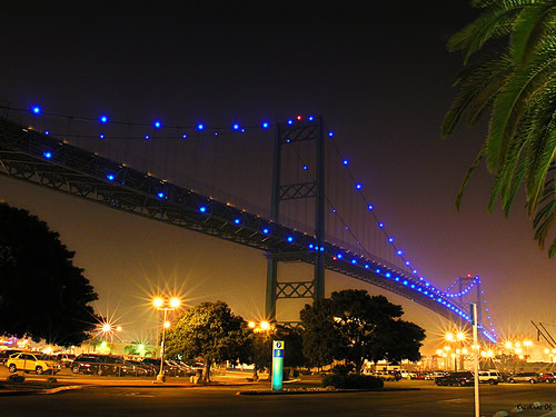
The Vincent Thomas Bridge stands tall as an iconic landmark in Los Angeles, California, connecting San Pedro with Terminal Island. As the only suspension bridge in the Greater Los Angeles area, it holds a significant place in the region’s history and infrastructure. Named after California Assemblyman Vincent Thomas, this engineering marvel has not only served as a vital link between communities but also witnessed remarkable stories of determination and tragedy.
A Bridge Born from Persistence:
The bridge’s construction was the result of Assemblyman Vincent Thomas’s unwavering dedication. Over a span of 19 years, Thomas tirelessly advocated for the necessary legislation to bring the bridge to life. Despite facing skepticism and being mockingly referred to as “The bridge to nowhere,” his perseverance paid off. In 1961, the California State Legislature passed a resolution naming the bridge after Thomas, recognizing his long-standing service.
Engineering Marvel and Notable Features:
The Vincent Thomas Bridge, completed in 1963, stands as a testament to innovative engineering. It was the first welded suspension bridge in the United States, showcasing the pioneering work of chief engineer William (Jim) Jurkovich. With a length of 1,500 feet (460 m), it spans Los Angeles Harbor and is supported entirely on piles, making it a unique structure in the world of suspension bridges. The bridge’s navigation channel boasts an impressive clearance height of approximately 185 feet (56 m), allowing ships to pass freely beneath it.
Connecting Communities and Boosting Commerce:
Before the bridge’s construction, ferry services played a crucial role in transporting workers to and from Terminal Island, supporting the cannery and shipyard industries. However, with the completion of the Vincent Thomas Bridge, a direct connection was established, revolutionizing transportation in the region. It not only facilitated the movement of people but also played a vital role in the success of the Port of Los Angeles, enabling the efficient transport of cargo. The bridge’s integration with the Harbor Freeway and Terminal Island Freeway further enhanced connectivity and economic growth.
Symbol of Remembrance and Resilience:
Over the years, the Vincent Thomas Bridge has witnessed both celebration and tragedy. In 1988, on its 25th anniversary, efforts were made to install permanent decorative lights, illuminating the bridge’s cables. In 2005, the illumination was upgraded to 160 blue LED lamps, powered by solar panels, giving the bridge a mesmerizing nighttime appearance. However, the bridge has also been the site of heartbreaking incidents. In 1990, Olympic diver Larry Andreasen lost his life attempting a record-breaking jump from the bridge’s west tower. Similarly, in 2012, acclaimed film director Tony Scott tragically took his own life by leaping from the bridge. These incidents serve as reminders of the bridge’s significance and the need for mental health awareness.
Future Upgrades and Preservation:
As time marches on, infrastructure needs to evolve. In 2023, the California Department of Transportation (Caltrans) proposed a substantial plan to replace the bridge’s road decking. This multimillion-dollar project, scheduled for construction between 2025 and 2027, aims to enhance the bridge’s functionality and ensure its longevity, preserving its status as a vital transportation artery.
The Vincent Thomas Bridge stands as an enduring symbol of connectivity, resilience, and progress. From its humble beginnings as a legislative dream to its status as a cherished landmark, the bridge continues to serve as a lifeline for communities and a testament to human ingenuity. As we look to the future, let us celebrate the bridge’s storied past while striving to preserve and enhance this remarkable feat of engineering for generations to come.
Fun and Notable Facts:
The Vincent Thomas Bridge has not only left its mark on the physical landscape of Los Angeles but has also made appearances in popular culture. The bridge has played a supporting role in numerous films, including the original 1974 “Gone in 60 Seconds” and its 2000 remake, “Lethal Weapon 2,” “To Live and Die in L.A.,” “City of Angels,” “Charlie’s Angels,” “Inception,” and “Den of Thieves.”
In the 1995 film “Heat,” Robert De Niro’s character mistakenly refers to the bridge as the “St. Vincent Thomas Bridge,” highlighting its recognition even in cinematic dialogue.
The bridge has also made notable appearances on television. In the CBS legal drama “Perry Mason,” the newly completed bridge is featured in a warehouse fire scene. It is also showcased in an episode of the original series “Mission: Impossible,” where the toll plaza takes center stage. Additionally, the bridge was featured in an episode of the crime series “CHiPs,” titled “Taking Its Toll,” and in the NBC show “Columbo.”
The Vincent Thomas Bridge has even made its way into the world of music videos, such as Jessica Simpson’s “I Think I’m in Love with You.”
In the gaming realm, the bridge has appeared in popular video games, including “Grand Theft Auto: San Andreas” as the Ocean Docks Bridge and “Grand Theft Auto V” as the Miriam Turner Overpass. It is also featured in “Need for Speed: Most Wanted,” “The Crew 2,” and “Need for Speed” as the South Port Bridge.
These appearances in films, television shows, music videos, and video games have cemented the Vincent Thomas Bridge’s cultural significance and made it an iconic symbol of Los Angeles.
https://en.wikipedia.org/wiki/Vincent_Thomas_Bridge
https://stmdailynews.com/category/the-bridge/urbanism


Few transportation systems in the world are as instantly recognizable as the cable cars of San Francisco. Climbing steep hills with a steady hum and a nostalgic charm, these moving landmarks are more than just a tourist attraction—they’re a triumph of innovation born out of necessity.
🐎 A Problem on the Hills
In the mid-1800s, San Francisco was growing rapidly, but its geography posed a serious challenge. The city’s steep inclines made travel difficult, especially for horse-drawn streetcars, which were the primary form of public transportation at the time.
Horses often struggled to pull heavy loads uphill, and accidents were common. In some cases, animals collapsed under the strain. This dangerous and inefficient system needed a solution.
💡 The Vision of Andrew Hallidie
That solution came from Andrew Smith Hallidie, an engineer and entrepreneur who envisioned a safer, more reliable way to move people through the city.
Hallidie developed a system in which streetcars would be pulled by a continuously moving cable running beneath the street—eliminating the need for horses altogether.
⚙️ The First Cable Car Line
On August 2, 1873, Hallidie launched the world’s first cable car system: the Clay Street Hill Railroad.
This groundbreaking line proved that cable-powered transit could successfully navigate San Francisco’s steep terrain. Instead of relying on animal power, cars used a mechanical grip to latch onto a moving cable underground, allowing them to glide smoothly up and down hills.
The innovation quickly captured public attention—and demand.
🚀 A City Transformed
Following the success of the Clay Street line, cable car systems spread rapidly across San Francisco.
By the late 19th century:
- Dozens of routes crisscrossed the city
- Cable cars became the backbone of urban transportation
- The system helped shape the city’s growth and accessibility
For a time, San Francisco operated the largest and most advanced cable car network in the world.
⚡ The Rise of Electric Streetcars
Despite their success, cable cars faced competition from emerging electric streetcar systems in the early 20th century. Electric trolleys were cheaper to build and operate, and they didn’t require the complex underground cable infrastructure.
The turning point came after the devastating 1906 San Francisco earthquake, which destroyed much of the city—including large portions of the cable car network.
When rebuilding began, many lines were converted to electric systems instead of restoring the older cable technology.
San Francisco’s cable car system, first launched in 1873, remains the last manually operated system of its kind. According to the San Francisco Municipal Transportation Agency (SFMTA) , the system was designed to safely navigate the city’s steep terrain.
The cable cars are now designated as a National Historic Landmark, recognized for their cultural and engineering significance by the National Park Service .
Visitors can explore the history and mechanics of the system at the San Francisco Cable Car Museum , which preserves original equipment and archives.
🛑 Saving a Symbol
By the 1940s, cable cars were on the brink of extinction.
That’s when Friedel Klussmann stepped in. A passionate preservationist, Klussmann led a public campaign to protect the remaining lines from being dismantled.
Her efforts culminated in a successful 1947 voter referendum that ensured the survival of San Francisco’s cable cars—transforming them from everyday transit into a preserved cultural landmark.
🌉 Cable Cars Today
Today, San Francisco’s cable cars are:
- The last manually operated cable car system in the world
- A National Historic Landmark
- One of the most visited attractions in California
Three lines remain in operation:
- Powell–Hyde Line
- Powell–Mason Line
- California Street Line
While they still function as public transit, they now serve as a moving museum—connecting modern riders with the city’s past.
🎯 Why It Matters
San Francisco’s cable cars represent more than a mode of transportation. They tell a story of innovation, resilience, and community action.
From solving a practical problem to becoming a global icon, the cable car system reflects how cities adapt—and how people fight to preserve what makes them unique.
📌 “Now You Know”
San Francisco’s cable cars weren’t built for tourism—they were invented to solve a life-and-death problem on steep city streets. Today, they remain the last system of their kind anywhere in the world.
🔗 External Sources & Related Links
- SFMTA – Cable Cars Overview
- San Francisco Cable Car Museum
- National Park Service – Historic Landmark Info
- Britannica – Cable Car History
- History.com – Invention of Cable Cars
Explore the latest in innovation, AI, gadgets, startups, and digital trends in STM Daily News’ Techsection.
Transportation
California High-Speed Rail Reaches Major Milestone as Track Installation Nears
California High-Speed Rail project reaches a major milestone with over 80 miles of guideway completed and track installation approaching. Learn what this means for the future of high-speed rail in the United States.
For years, California’s High-Speed Rail project has been the subject of debate, delays, and soaring cost estimates. Yet despite the challenges, the state’s ambitious effort to build America’s first true high-speed rail system has reached a significant milestone that signals tangible progress.
According to the California High-Speed Rail Authority, more than 80 miles of guideway structures have now been completed across the Central Valley, with active construction underway on approximately 119 miles of the future rail corridor. The project has also completed dozens of major infrastructure structures, including bridges, viaducts, and grade separations designed to carry trains traveling at speeds of up to 220 mph.
Perhaps the most important milestone is what comes next: track installation. After years of earthmoving, bridge construction, and utility relocation, the project is transitioning from building the pathway to building the railroad itself. This shift marks one of the clearest signs yet that the long-discussed system is moving closer to becoming operational.
Building the First Operating Segment
Current efforts are focused on creating an initial operating segment connecting Merced and Bakersfield through California’s Central Valley. Once completed, the line will serve communities including Merced, Fresno, Kings County, Tulare County, and Bakersfield.
The first operating segment is expected to span approximately 171 miles and is targeted for passenger service in the early 2030s. While this initial section does not yet connect the Bay Area or Los Angeles, state officials view it as a critical foundation for future expansion.
A Vision Decades in the Making
California voters approved funding for high-speed rail in 2008 with the vision of linking San Francisco and Los Angeles through a fast, environmentally friendly transportation system. Since then, the project has faced legal challenges, political opposition, funding uncertainties, and rising construction costs.
Supporters argue that the project will reduce highway congestion, lower greenhouse gas emissions, create jobs, and provide a modern transportation alternative for one of the nation’s most populated states.
Critics continue to question the project’s overall cost and timeline, particularly regarding future extensions to major metropolitan areas.
Why This Milestone Matters
Large infrastructure projects often progress slowly and out of public view. The completion of major structures and the upcoming installation of track represent visible signs that California’s high-speed rail system is advancing beyond planning and engineering.
While significant work remains before passengers can board a train, the project has entered a new phase—one focused on turning years of construction into a functioning rail network.
For Californians who have followed the project since its inception, this milestone serves as a reminder that despite setbacks and controversy, the state’s high-speed rail vision is steadily taking shape across the Central Valley.
As construction continues, the coming years will determine whether this first operating segment can become the launching point for a statewide high-speed transportation system connecting California’s largest cities.
Learn More About High-Speed Rail and Transportation Infrastructure
- California High-Speed Rail Authority Project Overview
- California High-Speed Rail Construction Updates
- Federal Railroad Administration: High-Speed Rail Information
- Brightline West: High-Speed Rail Connecting Southern California and Las Vegas
- Amtrak: America’s Passenger Rail Network
Source:
The California High-Speed Rail Authority (HSRA) project updates and 2026 Business Plan.
STM Daily News is a vibrant news blog dedicated to sharing the brighter side of human experiences. Emphasizing positive, uplifting stories, the site focuses on delivering inspiring, informative, and well-researched content. With a commitment to accurate, fair, and responsible journalism, STM Daily News aims to foster a community of readers passionate about positive change and engaged in meaningful conversations. Join the movement and explore stories that celebrate the positive impacts shaping our world.
Urbanism
LA Metro’s D Line Extension Phase 1 Officially Opens, Bringing Subway Service to Mid-Wilshire and Beverly Hills
LA Metro’s D Line Extension: LA Metro officially opens Phase 1 of the D Line Subway Extension, connecting Downtown Los Angeles, Mid-Wilshire, and Beverly Hills with three new underground stations.
The future of transportation in Los Angeles has officially arrived.
LA Metro’s D Line Extension Phase 1 Officially Opens
The Los Angeles County Metropolitan Transportation Authority (Metro) officially opened Section 1 of the long-awaited D Line Subway Extension on May 8, 2026, expanding underground rail service westward through the historic Mid-Wilshire corridor and into Beverly Hills.
The 3.92-mile extension is one of Metro’s most ambitious transit infrastructure projects and marks a major milestone in Los Angeles public transportation. The new section extends subway service beyond the current Wilshire/Western station in Koreatown and introduces three new underground stations:
- Wilshire/La Brea
- Wilshire/Fairfax
- Wilshire/La Cienega
The expansion is part of Metro’s larger “Twenty-Eight by ’28” initiative designed to improve mobility across the region ahead of the 2028 Olympic and Paralympic Games.
Downtown Los Angeles to Beverly Hills in About 20 Minutes
With the extension now open, riders can travel from Union Station in Downtown Los Angeles to Beverly Hills in approximately 20 minutes with no transfers required.
The D Line extension is expected to significantly improve travel along the heavily congested Wilshire Boulevard corridor, offering commuters, visitors and residents a faster and more reliable alternative to driving.
“Traveling through Mid-Wilshire to experience the culture, cuisine and commerce across diverse neighborhoods will be easier, faster and more accessible,” said Fernando Dutra, Metro Board Chair and City of Whittier Council Member.
Metro CEO Stephanie Wiggins also highlighted the importance of the project in connecting Angelenos to some of the city’s most iconic destinations.
“Angelenos and visitors alike will love the extended service from Downtown Los Angeles to Beverly Hills, delivering greater access to the iconic and culturally diverse communities, institutions and destinations that define the deep history along Wilshire Boulevard,” Wiggins said.
New Stations Connect Riders to Cultural Landmarks
Wilshire/La Brea Station
Located near Hancock Park and the western edge of Koreatown, the station provides access to cultural and entertainment destinations including:
- Korean Cultural Center
- Marciano Art Foundation
- Ebell Theater
- Popular restaurants including Republique and Sycamore Kitchen
Wilshire/Fairfax Station
Known as the heart of Museum Row, this station serves some of Los Angeles’ most recognizable cultural institutions and attractions, including:
- Los Angeles County Museum of Art (LACMA)
- Academy Museum of Motion Pictures
- Petersen Automotive Museum
- La Brea Tar Pits
- The Grove
- Original Farmers Market
The station also connects neighborhoods including Little Ethiopia, Park La Brea and the historic Fairfax District.
Wilshire/La Cienega Station
Serving as the eastern gateway to Beverly Hills, the station provides convenient access to Restaurant Row and destinations including the Beverly Center.
A Major Milestone for Los Angeles Transit
The D Line extension has been decades in the making and is widely considered one of the most important transit projects in Los Angeles history.
The project was funded primarily through Measure R, the voter-approved transportation sales tax passed in 2008, along with substantial federal funding support that included:
- $1.25 billion Full Funding Grant Agreement (FFGA)
- $66.4 million supplemental New Starts funding
- $749.3 million TIFIA loan
All three stations feature modern amenities including public artwork, enhanced lighting, cell phone service, bicycle hubs and improved pedestrian access.
Metro officials hope the extension will encourage more residents and visitors to use public transportation while helping reduce roadway congestion ahead of major international events scheduled for Los Angeles later this decade.
What’s Next for the D Line?
Construction is already underway on future phases of the D Line extension.
Phase 2 will continue west into Beverly Hills and Century City, while Phase 3 will eventually extend subway service to UCLA and the West Los Angeles VA campus.
Once completed, the D Line will provide a direct subway connection between Downtown Los Angeles and the Westside, dramatically reshaping mobility across one of Southern California’s busiest corridors.
Learn More
For official project details and station information, visit:
Metro D Line Opening Information
Stay connected with STM Daily News for the latest updates on Los Angeles transportation, Metro expansion projects, infrastructure developments, local news, technology, culture, and more. Visit STM Daily News for breaking stories, in-depth coverage, and exclusive content from across Southern California and beyond.


