Connect with us

News

US earthquake safety relies on federal employees’ expertise

Published

on

Last Updated on April 30, 2025 by Daily News Staff

earthquakes
The 6.9 magnitude Loma Prieta earthquake near San Francisco in 1989 caused about $6.8 billion in damage and 63 deaths.
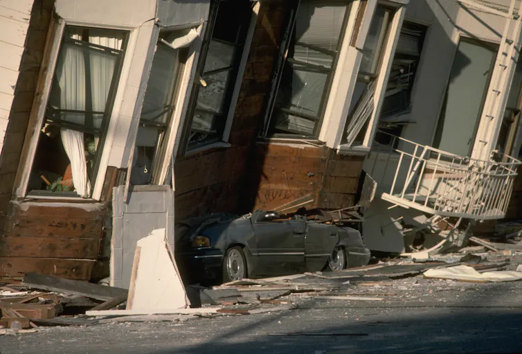
J.K. Nakata/U.S. Geological Survey

Jonathan P. Stewart, University of California, Los Angeles and Lucy Arendt, St. Norbert College

Earthquakes and the damage they cause are apolitical. Collectively, we either prepare for future earthquakes or the population eventually pays the price. The earthquakes that struck Myanmar on March 28, 2025, collapsing buildings and causing more than 3,000 deaths, were a sobering reminder of the risks and the need for preparation.

In the U.S., this preparation hinges in large part on the expertise of scientists and engineers in federal agencies who develop earthquake hazard models and contribute to the creation of building codes designed to ensure homes, high-rises and other structures won’t collapse when the ground shakes.

Local communities and states decide whether to adopt building code documents. But those documents and other essential resources are developed through programs supported by federal agencies working in partnership with practicing engineers and earthquake experts at universities.

This essential federal role is illustrated by two programs that we work closely with as an earthquake engineer and a disaster management expert whose work focuses on seismic risk.

Improving building codes

First, seismologists and earthquake engineers at the U.S. Geological Survey, or USGS, produce the National Seismic Hazard Model. These maps, based on research into earthquake sources such as faults and how seismic waves move through the earth’s crust, are used to determine the forces that structures in each community should be designed to resist.

A steering committee of earthquake experts from the private sector and universities works with USGS to ensure that the National Seismic Hazard Model implements the best available science.

Map shows the highest risk areas in Alaska, the Pacific Coast, Mountain West and Midwest. But strong earthquakes hit elsewhere, too.
In this 2023 update of the national seismic risk map, red areas have the greatest chance of a damaging earthquake occurring within 100 years.
USGS

Second, the Federal Emergency Management Agency, FEMA, supports the process for periodically updating building codes. That includes supporting the work of the National Institute of Building Sciences’ Provisions Update Committee, which recommends building code revisions based on investigations of earthquake damage.

More broadly, FEMA, the USGS, the National Institute of Standards and Technology and the National Science Foundation work together through the National Earthquake Hazards Reduction Program to advance earthquake science and turn knowledge of earthquake risks into safer standards, better building design and education. Some of those agencies have been threatened by potential job and funding cuts under the Trump administration, and others face uncertainty regarding continuation of federal support for their work.

It is in large part because of the National Seismic Hazard Model and regularly updated building codes that U.S. buildings designed to meet modern code requirements are considered among the safest in the world, despite substantial seismic hazards in several states.

This paradigm has been made possible by the technical expertise and lack of political agendas among the federal staff. Without that professionalism, we believe experts from outside the federal government would be less likely to donate their time.

Advertisement
Get More From A Face Cleanser And Spa-like Massage

The impacts of these and other programs are well documented. We can point to the limited fatalities from U.S. earthquakes such as the 1989 Loma Prieta earthquake near San Francisco, the 1994 Northridge earthquake in Los Angeles and the 2001 Nisqually earthquake near Seattle. Powerful earthquakes in countries lacking seismic preparedness, often due to lack of adoption or enforcement of building codes, have produced much greater devastation and loss of life.

The US has long relied on people with expertise

These programs and the federal agencies supporting them have benefited from a high level of staff expertise because hiring and advancement processes have been divorced from politics and focused on qualifications and merit.

This has not always been the case.

For much of early U.S. history, federal jobs were awarded through a patronage system, where political loyalty determined employment. As described in “The Federal Civil Service System and The Problem of Bureaucracy,” this system led to widespread corruption and dysfunction, with officials focused more on managing quid pro quo patronage than governing effectively. That peaked in 1881 with President James Garfield’s assassination by Charles Guiteau, a disgruntled supporter who had been denied a government appointment.

The passage of the Pendleton Act by Congress in 1883 shifted federal employment to a merit-based system. This preference for a merit-based system was reinforced in the Civil Service Reform Act of 1978. It states as national policy that “to provide the people of the United States with a competent, honest, and productive workforce … and to improve the quality of public service, Federal personnel management should be implemented consistent with merit system principles.”

The shift away from a patronage system produced a more stable and efficient federal workforce, which has enabled improvements in many critical areas, including seismic safety and disaster response.

Merit-based civil service matters for safety

While the work of these federal employees often goes unnoticed, the benefits are demonstrable and widespread. That becomes most apparent when disasters strike and buildings that meet modern code requirements remain standing.

A merit-based civil service is not just a democratic ideal but a proven necessity for the safety and security of the American people, one we hope will continue well into the future. This can be achieved by retaining federal scientists and engineers and supporting the essential work of federal agencies.

This article, originally published March 31, 2025, has been updated with the rising death toll in Myanamar.The Conversation

Jonathan P. Stewart, Professor of Engineering, University of California, Los Angeles and Lucy Arendt, Professor of Business Administration Management, St. Norbert College

This article is republished from The Conversation under a Creative Commons license. Read the original article.

Advertisement
Get More From A Face Cleanser And Spa-like Massage


Urbanism

LA Metro’s D Line Extension Phase 1 Officially Opens, Bringing Subway Service to Mid-Wilshire and Beverly Hills

LA Metro’s D Line Extension: LA Metro officially opens Phase 1 of the D Line Subway Extension, connecting Downtown Los Angeles, Mid-Wilshire, and Beverly Hills with three new underground stations.

Published

on

The future of transportation in Los Angeles has officially arrived.

LA Metro’s D Line Extension
Image: LA Metro

LA Metro’s D Line Extension Phase 1 Officially Opens

The Los Angeles County Metropolitan Transportation Authority (Metro) officially opened Section 1 of the long-awaited D Line Subway Extension on May 8, 2026, expanding underground rail service westward through the historic Mid-Wilshire corridor and into Beverly Hills.

The 3.92-mile extension is one of Metro’s most ambitious transit infrastructure projects and marks a major milestone in Los Angeles public transportation. The new section extends subway service beyond the current Wilshire/Western station in Koreatown and introduces three new underground stations:

  • Wilshire/La Brea
  • Wilshire/Fairfax
  • Wilshire/La Cienega

The expansion is part of Metro’s larger “Twenty-Eight by ’28” initiative designed to improve mobility across the region ahead of the 2028 Olympic and Paralympic Games.

Downtown Los Angeles to Beverly Hills in About 20 Minutes

With the extension now open, riders can travel from Union Station in Downtown Los Angeles to Beverly Hills in approximately 20 minutes with no transfers required.

The D Line extension is expected to significantly improve travel along the heavily congested Wilshire Boulevard corridor, offering commuters, visitors and residents a faster and more reliable alternative to driving.

“Traveling through Mid-Wilshire to experience the culture, cuisine and commerce across diverse neighborhoods will be easier, faster and more accessible,” said Fernando Dutra, Metro Board Chair and City of Whittier Council Member.

Metro CEO Stephanie Wiggins also highlighted the importance of the project in connecting Angelenos to some of the city’s most iconic destinations.

“Angelenos and visitors alike will love the extended service from Downtown Los Angeles to Beverly Hills, delivering greater access to the iconic and culturally diverse communities, institutions and destinations that define the deep history along Wilshire Boulevard,” Wiggins said.

New Stations Connect Riders to Cultural Landmarks

Wilshire/La Brea Station

Located near Hancock Park and the western edge of Koreatown, the station provides access to cultural and entertainment destinations including:

  • Korean Cultural Center
  • Marciano Art Foundation
  • Ebell Theater
  • Popular restaurants including Republique and Sycamore Kitchen

Wilshire/Fairfax Station

Known as the heart of Museum Row, this station serves some of Los Angeles’ most recognizable cultural institutions and attractions, including:

  • Los Angeles County Museum of Art (LACMA)
  • Academy Museum of Motion Pictures
  • Petersen Automotive Museum
  • La Brea Tar Pits
  • The Grove
  • Original Farmers Market

The station also connects neighborhoods including Little Ethiopia, Park La Brea and the historic Fairfax District.

Wilshire/La Cienega Station

Serving as the eastern gateway to Beverly Hills, the station provides convenient access to Restaurant Row and destinations including the Beverly Center.

A Major Milestone for Los Angeles Transit

The D Line extension has been decades in the making and is widely considered one of the most important transit projects in Los Angeles history.

The project was funded primarily through Measure R, the voter-approved transportation sales tax passed in 2008, along with substantial federal funding support that included:

  • $1.25 billion Full Funding Grant Agreement (FFGA)
  • $66.4 million supplemental New Starts funding
  • $749.3 million TIFIA loan

All three stations feature modern amenities including public artwork, enhanced lighting, cell phone service, bicycle hubs and improved pedestrian access.

Metro officials hope the extension will encourage more residents and visitors to use public transportation while helping reduce roadway congestion ahead of major international events scheduled for Los Angeles later this decade.

Advertisement
Get More From A Face Cleanser And Spa-like Massage

What’s Next for the D Line?

Construction is already underway on future phases of the D Line extension.

Phase 2 will continue west into Beverly Hills and Century City, while Phase 3 will eventually extend subway service to UCLA and the West Los Angeles VA campus.

Once completed, the D Line will provide a direct subway connection between Downtown Los Angeles and the Westside, dramatically reshaping mobility across one of Southern California’s busiest corridors.

Learn More

For official project details and station information, visit:

Metro D Line Opening Information

LA Metro Official Website

Stay connected with STM Daily News for the latest updates on Los Angeles transportation, Metro expansion projects, infrastructure developments, local news, technology, culture, and more. Visit STM Daily News for breaking stories, in-depth coverage, and exclusive content from across Southern California and beyond.

Continue Reading

Lifestyle

Small Business Month: Celebrating the Entrepreneurs Powering America

Published

on

Last Updated on May 9, 2026 by Daily News Staff

people working in an office. Small Business Month
Photo by Alena Darmel on Pexels.com

National Small Business Month

Every May, communities across the United States recognize Small Business Month, a time dedicated to celebrating the entrepreneurs, family-owned companies, startups, and local shops that help drive the American economy. From neighborhood restaurants to innovative tech startups, small businesses continue to play a vital role in creating jobs, supporting communities, and inspiring innovation.

Shop Local

According to the U.S. Small Business Administration, small businesses account for millions of jobs nationwide and represent the backbone of local economies. Throughout May, organizations, chambers of commerce, and business leaders host networking events, educational workshops, and promotional campaigns to support entrepreneurs and encourage consumers to shop locally.

One of the highlights of the month is National Small Business Week, which honors outstanding entrepreneurs and business owners making a difference in their communities.

For consumers, Small Business Month is also a reminder that supporting local businesses helps strengthen neighborhoods and keeps communities thriving. Whether it’s dining at a local café, shopping at an independent store, or hiring a local service provider, every purchase can make an impact.

Learn more about Small Business Month and related events through the official U.S. Small Business Administrationwebsite.

Related External Links

Our Lifestyle section on STM Daily News is a hub of inspiration and practical information, offering a range of articles that touch on various aspects of daily life. From tips on family finances to guides for maintaining health and wellness, we strive to empower our readers with knowledge and resources to enhance their lifestyles. Whether you’re seeking outdoor activity ideas, fashion trends, or travel recommendations, our lifestyle section has got you covered. Visit us today at https://stmdailynews.com/category/lifestyle/ and embark on a journey of discovery and self-improvement.

Continue Reading

The Knowledge

Artemis II crew brought a human eye and storytelling vision to the photos they took on their mission

Artemis II crew: Artemis II’s astronaut photos show how human perspective and storytelling make space imagery feel authentic—especially in an era of AI-generated visuals.

Published

on

file 20260410 57 xmsmko.jpg?ixlib=rb 4.1
Astronaut Jeremy Hansen takes a picture through the camera shroud covering a window on the Orion spacecraft. NASA

Christye Sisson, Rochester Institute of Technology

In early April 2026, the Artemis II mission captivated me and millions of people watching from across the world. The crew’s courage, skill and infectious wonder served as tangible proof of human persistence and technological achievement, all against the mysterious backdrop of space.

People back on Earth got to witness the mission through remarkable photos of space captured by astronauts. Images created and shared by astronauts underscore how photography builds a powerful, authentic connection that goes beyond what technology alone can capture.

As a photographer and the director of the Rochester Institute of Technology’s School of Photographic Arts and Sciences, I am especially drawn to how these photographs have been at the center of the public’s collective experience of this mission.

In an era when image authenticity is often questioned and with the capabilities of autonomous, AI-driven imaging, NASA’s choice to train astronauts in photography has placed meaning over convenience and prioritized their human perspectives and creativity.

Capturing space from the crew’s perspective

Photography was not originally placed as a high priority in NASA’s Apollo era. The astronauts only took photographs if they had the chance and all their other tasks were complete.

An image of the entire Earth from space.
‘The Blue Marble’ view of the Earth as seen by the Apollo 17 crew in 1972. NASA

Thanks largely in part to public response to those images from Apollo, including “Earthrise” and the “Blue Marble” being widely credited for helping catalyze the modern environmental movement, NASA shifted its approach to utilize photography to help capture the public’s imagination by training their astronauts in photographic practices.

The Artemis II mission’s photographs have helped cut through the increasing volume of artificially generated images circulating on social media. NASA’s social media releases of the crew’s photographs have garnered thousands of shares and comments.

This excitement could be explained by the novelty of photos from space, but these images also distinguish themselves as products of astronauts experiencing these sights and interpreting them through their photographs. These differences require an important distinction around where technology ends and humanity begins.

An astronaut looking out the window of the Orion spacecraft, where the full moon is visible in space.
NASA astronaut Reid Wiseman watches the Moon from one of the Orion spacecraft’s windows. NASA

Human perspective versus AI tools

Photography has long integrated AI-powered software and data-driven tools in a variety of ways: to process raw images, fill in missing color information, drive precise focus and guide image editing, among others. These modern technological assists help human photographers realize their vision.

Artificial intelligence is also increasingly capable of operating machinery competently and autonomously, from cars to drones and cameras.

And AI can generate convincing, realistic images and videos from nothing more than a text prompt, using readily available tools.

Researchers train AI to mimic patterns informed by millions of sample images, and the algorithm can then either take or create a photograph based on what it predicts would be the most likely version of a successful, believable image.

Advertisement
Get More From A Face Cleanser And Spa-like Massage

Human-created photos are rooted in direct observation, intent and lived experience, while AI images – or choices made by AI-driven tools – are not. While both can produce compelling and believable visuals, the human photographs carry emotional power because the photographer is drawing from their experiences and perspective in that moment to tell an authentic story.

Artemis II photographs resonate, not only because they are historic, but because they reflect the deliberate choices and intent of a human being in that specific moment and context. The exposure, camera setting, lens choice and composition are all dictated by the astronaut’s vision, skill, perspective and experience. Each image is unique in comparison with the others. These choices give the images narrative power, anchoring them in human perspective.

The Earth shown partially shadowed beyond the Moon in space
NASA’s ‘Earthset’ photo captured by the Artemis II crew. NASA

Images to tell a story

Photographers choose what to include in the final version of their image to tell a story. In the Artemis II images, this human perspective comes out. In the “Earthset” photo, you see a striking juxtaposition of the Moon’s monochromatic, textured surface in the foreground against a slivered, bright Earth.

The choice to include both in the frame contrasts these objects literally and figuratively, inviting comparison. It creates a narrative where Earth is contrasted against the Moon – life is contrasted against the absence of it.

Another photo shows the nightside of the whole Earth, featuring the Sun’s halo, auroras and city lights. The choice to include the subtle framing of the window of the capsule in the lower left corner reminds the viewer where and how this image was captured: by a human, inside a capsule, hurtling through space. That detail grounds the photograph in the human perspective.

Both photos are reminiscent of Earthrise and the Blue Marble. These past images hold a place in the global collective consciousness, shaped by a shared historical moment.

The Artemis II photographs are anchored in this collective moment of lived human experience, yet also shaped by each astronaut’s viewpoint. The crew’s unique perspectives exemplify photography’s transformative power by inviting viewers to engage emotionally and intellectually with their journey. These photographs share the astronauts’ awe and wonder and affirm the value of human creativity and its ability to connect us in a captured moment.

Christye Sisson, Professor of Photographic Sciences, Rochester Institute of Technology

This article is republished from The Conversation under a Creative Commons license. Read the original article.

Dive into “The Knowledge,” where curiosity meets clarity. This playlist, in collaboration with STMDailyNews.com, is designed for viewers who value historical accuracy and insightful learning. Our short videos, ranging from 30 seconds to a minute and a half, make complex subjects easy to grasp in no time. Covering everything from historical events to contemporary processes and entertainment, “The Knowledge” bridges the past with the present. In a world where information is abundant yet often misused, our series aims to guide you through the noise, preserving vital knowledge and truths that shape our lives today. Perfect for curious minds eager to discover the ‘why’ and ‘how’ of everything around us. Subscribe and join in as we explore the facts that matter.  https://stmdailynews.com/the-knowledge/

Author

Continue Reading

Trending