R.G. McGimsey/Alaska Volcano Observatory/U.S. Geological Survey, CC BY
David Kitchen, University of Richmond
Volcanoes inspire awe with spectacular eruptions and incandescent rivers of lava, but often their deadliest hazard is what quietly falls from the sky.
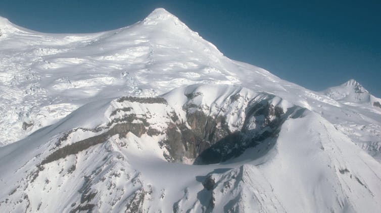
When a large volcano erupts, as Mount Spurr appears close to doing about 80 miles from Anchorage, Alaska, it can release enormous volumes of ash. Fine ash can infiltrate the lungs of people and animals who breathe it in, poison crops and disrupt aquatic life. Thick deposits of ash can collapse roofs, cripple utilities and disrupt transport networks.
Ash may lack the visual impact of flowing lava, but as a geologist who studies disasters, I’m aware that ash travels farther, lasts longer and leaves deep scars.
Volcano Hazards Program, U.S. Geological Survey
Volcanic ash: What it is, and why it matters
Volcanic ash forms when viscous magma – molten rock from deep beneath Earth’s surface – erupts, exploding into shards of rock, mineral and glass carried in a near-supersonic stream of hot gas.
Towering clouds of ash rise several miles into the atmosphere, where the ash is captured by high-altitude winds that can carry it hundreds or even thousands of miles.
As the volcanic ash settles back to Earth, it accumulates in layers that typically decrease in thickness with distance from the eruption source. Near the vent, the ash may be several feet deep, but communities farther away may see only a dusting.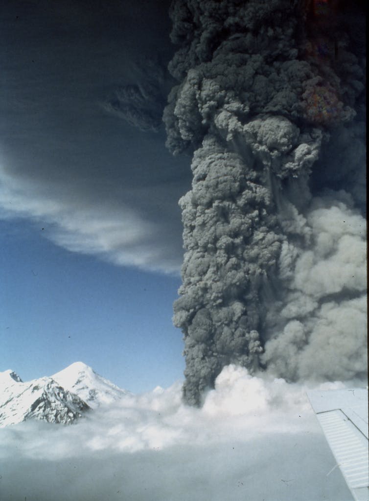
U.S. Geological Survey
Breathing danger: Health risks from ash
Breathing volcanic ash can irritate the throat and lungs, trigger asthma attacks and aggravate chronic respiratory conditions such as COPD.
The finest particles pose the greatest risk because they can penetrate deep into the lungs and cause death by asphyxiation in the worst cases. Mild, short-term symptoms often resolve with rest. However, the long-term consequences of ash exposure can include silicosis, a lung disease and a possible cause of cancer.
The danger increases in dry regions where fallen ash can be kicked up into the air again by wind or human activity.
Risks to pets and livestock
Humans aren’t the only ones at risk. Animals experience similar respiratory symptoms to humans.
Domestic pets can develop respiratory distress, eye inflammation and paw irritation from exposure to ash.

Federico Grosso/U.S. Geological Survey
Livestock face greater dangers. If grazing animals eat volcanic ash, it can damage their teeth, block their intestines and poison them.
During the 2010 Eyjafjallajökull eruption in Iceland, farmers were advised to shelter sheep and cattle because the ash contained fluoride concentrations above the recognized safety threshold of 400 parts per million. Animals that remained exposed became sick and some died.
Harm to crops, soil and water
Soil and crops can also be damaged. Volcanic ash alters the acidity of soil and introduces harmful elements such as arsenic and sulfur into the environment.
While the ash can add nutrients such as potassium and phosphorus that enhance fertility, the immediate impact is mostly harmful.
Ash can smother crops, block sunlight and clog the tiny stomata, or pores, in leaves that allow plants to exchange gases with the atmosphere. It can also introduce toxins that render food unmarketable. Vegetables, fruit trees and vines are particularly vulnerable, but even sturdy cereals and grasses can die if ash remains on leaves or poisons emerging shoots.
Following the 1991 Mount Pinatubo eruption, vast tracts of farmland in central Luzon in the Philippines were rendered unproductive for years due to acidic ash and buried topsoil. If multiple ashfalls occur in a growing season, crop failure becomes a near certainty. It was the cause of a historic famine that followed the eruption of Mount Tambora in 1815.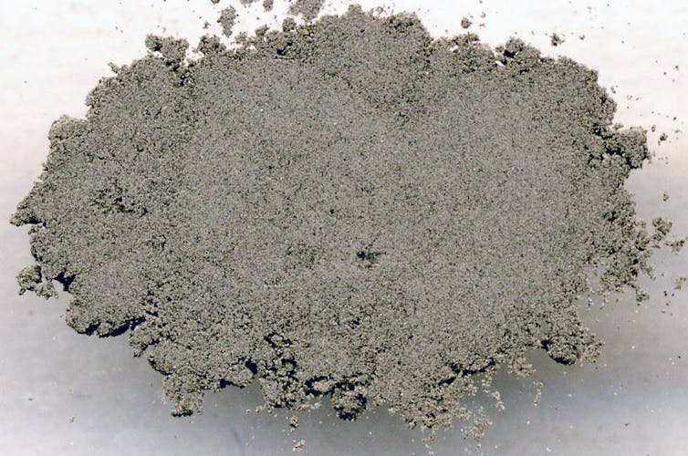
James St. John via Wikimedia Commons, CC BY
Volcano Hazards Program, U.S. Geological Survey
Ash can also contaminate surface water by introducing toxins and increasing the water’s acidity. The toxins can leach into groundwater, contaminating wells. Fine ash particles can also settle in waterways and smother aquatic plants and animals. During the 2008 Chaitén eruption in Chile, ash contamination led to widespread fish deaths in the Río Blanco.
Ash can ground airplanes, gum up infrastructure
Ash clouds are extremely dangerous to aircraft. The glassy ash particles melt when sucked into jet turbines, clog fuel systems and can stall engines in midair.
In 1982, British Airways Flight 9 lost power in all four engines after flying through an ash cloud. A similar incident occurred in 1989 to KLM Flight 867 over Alaska. In 2010, Iceland’s Eyjafjallajökull eruption grounded more than 100,000 flights across Europe, disrupting travel for over 10 million passengers and costing the global economy billions of dollars.
Volcanic ash can also wreak havoc on infrastructure by clogging water supplies, short-circuiting electrical systems and collapsing roofs under its weight. It can disrupt transportation, communication, rescue and power networks, as the 1991 eruption of Mount Pinatubo in the Philippines dramatically demonstrated.
What to do during ashfall
During an ashfall event, the most effective strategy to stay safe is to stay indoors as much as possible and avoid inhaling ash particles.
Anyone who must go outside should wear a properly fitted N95 or P2 mask. Cloth masks provide little protection against fine ash. Rainwater tanks, troughs and open wells should be covered and monitored for contamination. Livestock should be moved to clean pastures or given uncontaminated fodder.
To reduce structural damage, ash should be cleared from roofs and gutters promptly, especially before rainfall.
Older adults, children and people who are sick are at greatest risk, particularly those living in poorly ventilated homes. Rural communities that are dependent on agriculture and livestock are disproportionately affected by ashfall, as are low-income people who lack access to clean water, protective masks or safe shelter.
Communities can stay informed about ash risks through official alerts, including those from the Volcanic Ash Advisory Centers, which monitor ash dispersion and issue timely warnings. The International Volcanic Health Hazard Network also offers guidelines on personal protection, emergency planning and ash cleanup.
The long tail of ash
Volcanic ash may fall quietly, but its effects are widespread, persistent and potentially deadly. It poses a chronic threat to health, agriculture, infrastructure and aquatic systems.
Recognizing the risk is a crucial first step to protecting lives. Effective planning and public awareness can further help reduce the damage.
David Kitchen, Associate Professor of Geology, University of Richmond
This article is republished from The Conversation under a Creative Commons license. Read the original article.