

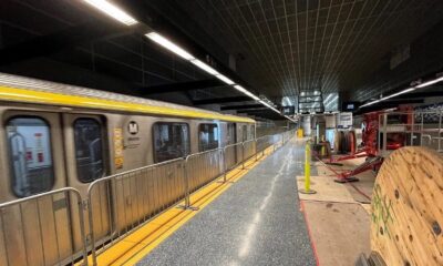
The Long Track Back
What’s Next for LA Metro: 2028 and Beyond — The Final Episode of The Long Track Back
As LA prepares to host the 2028 Olympics, Metro is racing to reshape how the city moves. Our final episode of The Long Track Back explores what’s next — and whether LA can finally become a true transit city.
Last Updated on August 10, 2025 by Daily News Staff

🚊 Can Los Angeles Finally Become a Real Transit City — In Time for the 2028 Olympics?
That’s the bold question we ask in the final episode of The Long Track Back, our in-depth video series examining the history, challenges, and future of LA’s transit system.
In this finale, titled “What’s Next for LA Metro: 2028 and Beyond,” we look forward — to a city under construction, to billion-dollar investments in mobility, and to a pivotal moment as Los Angeles races toward hosting the 2028 Summer Olympic Games.
🎥 Watch the episode here: https://youtu.be/DcXa2Z2_9U4
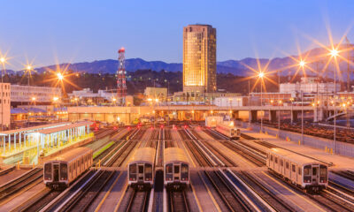
🚧 LA Metro’s Big Bets for 2028
From subway tunneling beneath Wilshire Boulevard to sleek new rail lines connecting LAX to the city, Metro is charging ahead with its most ambitious slate of projects ever. These include:
D Line Extension — connecting Westwood, Beverly Hills, and Koreatown to the city core LAX People Mover — a long-awaited fix to one of LA’s biggest airport headaches Sepulveda Transit Corridor — still in planning, this could become a high-capacity subway… or a high-speed monorail
Together, these projects are part of the “28 by 2028” initiative — a Metro campaign to complete 28 major transit improvements in time for the Games.
💡 Infrastructure vs. Mindset
But as our episode explores, concrete and steel aren’t enough. LA’s biggest challenge may not be building the systems — it’s getting Angelenos to use them.
From car culture to last-mile connections, public perception still looms large. But that’s slowly shifting, with younger generations, students, and eco-conscious riders embracing Metro like never before.
🚂 Echoes of the Past, Visions of the Future
“The Red Cars may be gone,” our narrator says, “but their legacy lives on — in every station being built, every line extended, and every rider who says, ‘Why drive when I can take the train?’”
It’s a poetic reminder that Los Angeles was once a transit-first city. And maybe, just maybe, it can be again.
🎙️ This May Be the Final Episode — But It’s Not the End
The Long Track Back has taken viewers from the rise and fall of the Pacific Electric system to the rebirth of LA Metro. This final installment is a turning point — not a conclusion.
🚦Watch the full series and explore bonus interviews, maps, and timelines at STMDailyNews.com.
🎧 Subscribe to the podcast for new episodes diving deeper into the future of urban transportation in Southern California and beyond
Dive into “The Knowledge,” where curiosity meets clarity. This playlist, in collaboration with STMDailyNews.com, is designed for viewers who value historical accuracy and insightful learning. Our short videos, ranging from 30 seconds to a minute and a half, make complex subjects easy to grasp in no time. Covering everything from historical events to contemporary processes and entertainment, “The Knowledge” bridges the past with the present. In a world where information is abundant yet often misused, our series aims to guide you through the noise, preserving vital knowledge and truths that shape our lives today. Perfect for curious minds eager to discover the ‘why’ and ‘how’ of everything around us. Subscribe and join in as we explore the facts that matter. https://stmdailynews.com/the-knowledge/
Author


Last Updated on April 4, 2026 by Daily News Staff

Few transportation systems in the world are as instantly recognizable as the cable cars of San Francisco. Climbing steep hills with a steady hum and a nostalgic charm, these moving landmarks are more than just a tourist attraction—they’re a triumph of innovation born out of necessity.
🐎 A Problem on the Hills
In the mid-1800s, San Francisco was growing rapidly, but its geography posed a serious challenge. The city’s steep inclines made travel difficult, especially for horse-drawn streetcars, which were the primary form of public transportation at the time.
Horses often struggled to pull heavy loads uphill, and accidents were common. In some cases, animals collapsed under the strain. This dangerous and inefficient system needed a solution.
💡 The Vision of Andrew Hallidie
That solution came from Andrew Smith Hallidie, an engineer and entrepreneur who envisioned a safer, more reliable way to move people through the city.
Hallidie developed a system in which streetcars would be pulled by a continuously moving cable running beneath the street—eliminating the need for horses altogether.
⚙️ The First Cable Car Line
On August 2, 1873, Hallidie launched the world’s first cable car system: the Clay Street Hill Railroad.
This groundbreaking line proved that cable-powered transit could successfully navigate San Francisco’s steep terrain. Instead of relying on animal power, cars used a mechanical grip to latch onto a moving cable underground, allowing them to glide smoothly up and down hills.
The innovation quickly captured public attention—and demand.
🚀 A City Transformed
Following the success of the Clay Street line, cable car systems spread rapidly across San Francisco.
By the late 19th century:
- Dozens of routes crisscrossed the city
- Cable cars became the backbone of urban transportation
- The system helped shape the city’s growth and accessibility
For a time, San Francisco operated the largest and most advanced cable car network in the world.
⚡ The Rise of Electric Streetcars
Despite their success, cable cars faced competition from emerging electric streetcar systems in the early 20th century. Electric trolleys were cheaper to build and operate, and they didn’t require the complex underground cable infrastructure.
The turning point came after the devastating 1906 San Francisco earthquake, which destroyed much of the city—including large portions of the cable car network.
When rebuilding began, many lines were converted to electric systems instead of restoring the older cable technology.
San Francisco’s cable car system, first launched in 1873, remains the last manually operated system of its kind. According to the San Francisco Municipal Transportation Agency (SFMTA) , the system was designed to safely navigate the city’s steep terrain.
The cable cars are now designated as a National Historic Landmark, recognized for their cultural and engineering significance by the National Park Service .
Visitors can explore the history and mechanics of the system at the San Francisco Cable Car Museum , which preserves original equipment and archives.
🛑 Saving a Symbol
By the 1940s, cable cars were on the brink of extinction.
That’s when Friedel Klussmann stepped in. A passionate preservationist, Klussmann led a public campaign to protect the remaining lines from being dismantled.
Her efforts culminated in a successful 1947 voter referendum that ensured the survival of San Francisco’s cable cars—transforming them from everyday transit into a preserved cultural landmark.
🌉 Cable Cars Today
Today, San Francisco’s cable cars are:
- The last manually operated cable car system in the world
- A National Historic Landmark
- One of the most visited attractions in California
Three lines remain in operation:
- Powell–Hyde Line
- Powell–Mason Line
- California Street Line
While they still function as public transit, they now serve as a moving museum—connecting modern riders with the city’s past.
🎯 Why It Matters
San Francisco’s cable cars represent more than a mode of transportation. They tell a story of innovation, resilience, and community action.
From solving a practical problem to becoming a global icon, the cable car system reflects how cities adapt—and how people fight to preserve what makes them unique.
📌 “Now You Know”
San Francisco’s cable cars weren’t built for tourism—they were invented to solve a life-and-death problem on steep city streets. Today, they remain the last system of their kind anywhere in the world.
🔗 External Sources & Related Links
- SFMTA – Cable Cars Overview
- San Francisco Cable Car Museum
- National Park Service – Historic Landmark Info
- Britannica – Cable Car History
- History.com – Invention of Cable Cars
Explore the latest in innovation, AI, gadgets, startups, and digital trends in STM Daily News’ Techsection.

LOS ANGELES — Century Boulevard is one of the most recognizable east–west corridors in South Los Angeles, stretching from Watts to Los Angeles International Airport (LAX). But despite its grand-sounding name, the origin of “Century” is surprisingly simple—and rooted in math.
The Meaning Behind “Century”
Century Boulevard sits roughly 100 blocks south of downtown Los Angeles, where the city’s street numbering system begins at 1st Street and Main Street. Instead of naming the road “100th Street,” city planners opted for a more distinctive and memorable name: Century Boulevard.
In this case, “Century” literally means 100.
Part of Los Angeles’ Grid System
Los Angeles was designed using a grid-based street layout, especially in its expanding southern neighborhoods during the early 20th century. Streets were often named or numbered based on their distance from downtown.
Century Boulevard aligns with what would have been the 100th Street corridor—making it a key reference point in the city’s geography.
A Street That Evolved Over Time
Before it became Century Boulevard, portions of the roadway were known by other names, including Pine Avenue and San Antonio Street. As the region developed and expanded, these segments were unified under a single name in the 1920s.
This consolidation helped streamline navigation and supported growing transportation needs.
From Local Road to Global Gateway
The importance of Century Boulevard grew significantly with the rise of Los Angeles International Airport (LAX). Today, it serves as a major gateway for millions of travelers entering the city.
The road connects diverse communities—from historic neighborhoods in South Los Angeles to the bustling airport corridor—making it both a local lifeline and an international entry point.
More Than Just a Name
Century Boulevard reflects a broader pattern in Los Angeles street naming:
- Some streets honor historical figures
- Others reflect geography or culture
- And some, like Century, are rooted in the city’s structured grid system
It’s a reminder that even the most ordinary street names can reveal deeper stories about how a city was built.
The Bottom Line
Century Boulevard isn’t named after an event—it’s named for its location. Positioned at the 100th Street line, it represents both the logic of Los Angeles’ design and the growth of the city over time.
Now you know.
Related External Links
- Century Boulevard – Overview and History
- Los Angeles International Airport (LAX) – Official Website
- Los Angeles City Planning Department
- Los Angeles Public Library: The Story Behind LA Street Names
- LA Metro – Transportation System Information
- Calisphere – Historical Images and Maps of Los Angeles
Dive into “The Knowledge,” where curiosity meets clarity. This playlist, in collaboration with STMDailyNews.com, is designed for viewers who value historical accuracy and insightful learning. Our short videos, ranging from 30 seconds to a minute and a half, make complex subjects easy to grasp in no time. Covering everything from historical events to contemporary processes and entertainment, “The Knowledge” bridges the past with the present. In a world where information is abundant yet often misused, our series aims to guide you through the noise, preserving vital knowledge and truths that shape our lives today. Perfect for curious minds eager to discover the ‘why’ and ‘how’ of everything around us. Subscribe and join in as we explore the facts that matter. https://stmdailynews.com/the-knowledge/
The Knowledge
Why Phoenix’s Skyline Has Stayed Low — And How It Compares to Los Angeles
Discover why Phoenix’s skyline lacks supertall skyscrapers, from FAA flight path limits near Phoenix Sky Harbor International Airport to how it compares with Los Angeles’s skyline growth.
Last Updated on March 25, 2026 by Daily News Staff
Phoenix is the fifth-largest city in the United States, yet its skyline doesn’t resemble other major metros like Los Angeles, Chicago, or Dallas. Despite rapid population and economic growth, downtown Phoenix has long lacked supertall skyscrapers — and until recently, didn’t even have a building tall enough to qualify as a true “skyscraper” under standard definitions.
The Basics: Phoenix’s Height Reality
The tallest structure in Phoenix for decades has been Chase Tower, rising to about 483 feet. Under the Council on Tall Buildings and Urban Habitat definition, a skyscraper reaches at least 492 feet — which means Phoenix has technically lacked one — despite its size and population.
A new project, the Astra Tower, is planned to rise around 540+ feet when it breaks ground, potentially giving Phoenix its first true skyscraper.
Airport Proximity: The FAA’s Height Grid
FAA Obstacle Evaluation & Downtown Limits
Phoenix’s skyline constraints are rooted in aviation safety.
📍 Phoenix Sky Harbor International Airport sits just a few miles from downtown.
- The Federal Aviation Administration (FAA) regulates building heights near airports so they don’t obstruct flight paths, require planes to alter approaches, or interfere with climb-out safety.
- In Phoenix, this results in a layered set of height limits that vary by location and elevation above sea level — often measured in feet above mean sea level (MSL) rather than simply building height from ground.
The city’s zoning code divides downtown into multiple contour zones with distinct maximum elevation values (e.g., 1,275 ft, 1,525 ft, 1,700 ft MSL), each tied to how close it sits under airport flight paths.
That means in some blocks you can’t build above a specific elevation even if ground levels are lower — a regulatory “roof” that varies across downtown.
City zoning also explicitly states that no building can exceed the FAA’s airport height limits, even if other bonuses or zoning allowances exist.
Phoenix vs. Los Angeles: A Quick Comparison
Los Angeles: Higher Limits, Different Constraints
Cities like Los Angeles also have nearby airports (e.g., Los Angeles International Airport), but their key business districts aren’t directly under major flight corridors.
LA’s downtown has:
- Taller office and residential towers
- A financial core with dense development
- Fewer FAA-driven overlays because the flight paths stretch past the downtown edge
Los Angeles’s tallest buildings — including Wilshire Grand Center (~1,100 ft) and U.S. Bank Tower (~1,018 ft) — were built where FAA restrictions don’t force low ceilings. FAA evaluations were conducted but didn’t cut as deeply into downtown zoning compared to Phoenix.
Phoenix, by contrast, sits right under approach and departure corridors — leading to consistent FAA involvement in almost every proposed mid- or high-rise downtown.
Economic and Planning Philosophies
Beyond FAA rules:
- Phoenix developed in the automobile era, with vast inexpensive land encouraging horizontal growth.
- Los Angeles grew earlier with heavier investment in centralized neighborhoods and higher density.
- Phoenix’s village plan long encouraged multiple smaller hubs instead of concentrating all growth in one downtown core.
These historical differences mean Phoenix didn’t have the same economic “pressure” to build up — even with zoning that allows significant height if FAA permits are met.
What This Means for Phoenix’s Future
Phoenix still has room to grow vertically — but:
- FAA height contours will remain the ceiling unless flight paths change
- Developers must secure determinations of no hazard from the FAA before going taller
- New projects like Astra show demand for taller buildings is rising
As Phoenix’s urban core densifies and land becomes scarcer, its skyline may yet reach higher — but always within the invisible grid drawn by aviation safety.
Related External Links
- Phoenix Sky Harbor International Airport Official Website
- FAA Obstruction Evaluation / Airport Airspace Analysis (OE/AAA)
- City of Phoenix Planning & Development Department
- Council on Tall Buildings and Urban Habitat (CTBUH)
- Los Angeles World Airports (LAX Authority)
- Phoenix Skyscraper Database & Diagrams
- Los Angeles Skyscraper Database & Diagrams
Dive into “The Knowledge,” where curiosity meets clarity. This playlist, in collaboration with STMDailyNews.com, is designed for viewers who value historical accuracy and insightful learning. Our short videos, ranging from 30 seconds to a minute and a half, make complex subjects easy to grasp in no time. Covering everything from historical events to contemporary processes and entertainment, “The Knowledge” bridges the past with the present. In a world where information is abundant yet often misused, our series aims to guide you through the noise, preserving vital knowledge and truths that shape our lives today. Perfect for curious minds eager to discover the ‘why’ and ‘how’ of everything around us. Subscribe and join in as we explore the facts that matter. https://stmdailynews.com/the-knowledge/


