Transportation
California High-Speed Rail Reaches Major Milestone as Track Installation Nears
California High-Speed Rail project reaches a major milestone with over 80 miles of guideway completed and track installation approaching. Learn what this means for the future of high-speed rail in the United States.

For years, California’s High-Speed Rail project has been the subject of debate, delays, and soaring cost estimates. Yet despite the challenges, the state’s ambitious effort to build America’s first true high-speed rail system has reached a significant milestone that signals tangible progress.
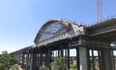
According to the California High-Speed Rail Authority, more than 80 miles of guideway structures have now been completed across the Central Valley, with active construction underway on approximately 119 miles of the future rail corridor. The project has also completed dozens of major infrastructure structures, including bridges, viaducts, and grade separations designed to carry trains traveling at speeds of up to 220 mph.
Perhaps the most important milestone is what comes next: track installation. After years of earthmoving, bridge construction, and utility relocation, the project is transitioning from building the pathway to building the railroad itself. This shift marks one of the clearest signs yet that the long-discussed system is moving closer to becoming operational.
Building the First Operating Segment
Current efforts are focused on creating an initial operating segment connecting Merced and Bakersfield through California’s Central Valley. Once completed, the line will serve communities including Merced, Fresno, Kings County, Tulare County, and Bakersfield.
The first operating segment is expected to span approximately 171 miles and is targeted for passenger service in the early 2030s. While this initial section does not yet connect the Bay Area or Los Angeles, state officials view it as a critical foundation for future expansion.
A Vision Decades in the Making
California voters approved funding for high-speed rail in 2008 with the vision of linking San Francisco and Los Angeles through a fast, environmentally friendly transportation system. Since then, the project has faced legal challenges, political opposition, funding uncertainties, and rising construction costs.
Supporters argue that the project will reduce highway congestion, lower greenhouse gas emissions, create jobs, and provide a modern transportation alternative for one of the nation’s most populated states.
Critics continue to question the project’s overall cost and timeline, particularly regarding future extensions to major metropolitan areas.
Why This Milestone Matters
Large infrastructure projects often progress slowly and out of public view. The completion of major structures and the upcoming installation of track represent visible signs that California’s high-speed rail system is advancing beyond planning and engineering.
While significant work remains before passengers can board a train, the project has entered a new phase—one focused on turning years of construction into a functioning rail network.
For Californians who have followed the project since its inception, this milestone serves as a reminder that despite setbacks and controversy, the state’s high-speed rail vision is steadily taking shape across the Central Valley.
As construction continues, the coming years will determine whether this first operating segment can become the launching point for a statewide high-speed transportation system connecting California’s largest cities.
Learn More About High-Speed Rail and Transportation Infrastructure
- California High-Speed Rail Authority Project Overview
- California High-Speed Rail Construction Updates
- Federal Railroad Administration: High-Speed Rail Information
- Brightline West: High-Speed Rail Connecting Southern California and Las Vegas
- Amtrak: America’s Passenger Rail Network
Source:
The California High-Speed Rail Authority (HSRA) project updates and 2026 Business Plan.
STM Daily News is a vibrant news blog dedicated to sharing the brighter side of human experiences. Emphasizing positive, uplifting stories, the site focuses on delivering inspiring, informative, and well-researched content. With a commitment to accurate, fair, and responsible journalism, STM Daily News aims to foster a community of readers passionate about positive change and engaged in meaningful conversations. Join the movement and explore stories that celebrate the positive impacts shaping our world.



Transportation
LAX SkyLink Delayed Again, With Passenger Service Now Targeted for January 2027
LAX SkyLink has been delayed again. The long-awaited airport train is now targeting passenger service in January 2027 as final testing and certification continue.
The long-awaited airport train is nearly complete, but additional testing and certification have pushed its anticipated debut beyond 2026.
LOS ANGELES — Travelers waiting for Los Angeles International Airport’s long-delayed SkyLink train will apparently have to wait a little longer.
The automated train system, previously expected to begin carrying passengers as early as October 2026, is now being targeted for early January 2027, according to new project disclosures.
LAX Integrated Express Solutions, or LINXS, the consortium responsible for the project, indicated in a September 16 disclosure that passenger service could begin around January 6, 2027, if remaining work proceeds successfully. However, LINXS also cautioned that additional delays remain possible.
Importantly, January 6 is not an official opening date announced by Los Angeles World Airports.
LAWA’s official SkyLink website currently says only that the system is in its “final testing and certification phase”and that opening information will be announced when available.
What Happened to the October Opening?
As STM Daily News previously reported, the project had been moving toward a possible October 2026 passenger-service launch.
That timetable has now slipped.
According to the latest project information, SkyLink still must successfully complete several important requirements before passengers can board.
Those include 30 consecutive days of successful testing, an independent review, an assessment by LAWA and completion of a utility agreement involving the Los Angeles Department of Water and Power.
The project’s contractual completion deadline currently stands at December 8, 2026, but LINXS has indicated that additional time may be necessary.
That puts the tentative January 6 passenger-service target roughly one month beyond the current contractual completion deadline.
Those Trains You See Are Still Test Trains
For passengers traveling through LAX, the delay might seem particularly puzzling because SkyLink trains can already be seen moving around the airport.
Those trains aren’t carrying passengers.
LAX says the vehicles are operating throughout the system as part of testing required before passenger service can begin.
The airport’s official SkyLink page specifically warns travelers that any trains currently moving are part of testing and are not in service.
The project is reportedly about 99% complete, meaning the primary infrastructure is essentially in place while testing, certification and remaining agreements continue.
Another Delay in a Long-Running Project
Construction on the 2.25-mile automated train system began in 2019, and passenger service was originally expected to begin in 2023.
That opening has repeatedly slipped as the approximately $3.3 billion project encountered construction issues, technical challenges and disputes between LAWA and LINXS.
The relationship between the two sides has also become increasingly contentious.
LINXS sued the City of Los Angeles earlier this year, alleging that actions by LAWA contributed to delays and additional costs. LAWA has said completing a safe and reliable SkyLink remains its priority.
The financial stakes are also increasing. Bondholders recently agreed to consolidate an earlier October deadline into the December 8 project deadline, giving the consortium additional time to complete the remaining work.
Why SkyLink Still Matters
Despite the delays, SkyLink remains one of the most consequential pieces of LAX’s massive modernization program.
The free, all-electric automated train will operate along a 2.25-mile elevated guideway with six stations.
Three stations will serve the airport’s Central Terminal Area, while others will connect passengers with parking, rental cars, ground transportation and the LAX/Metro Transit Center.
That last connection is especially significant.
The Transit Center provides access to Metro’s C and K Lines. Until SkyLink opens, however, passengers using Metro must continue transferring to shuttle buses to reach the airport terminals.
Once operational, SkyLink is designed to eliminate that final shuttle connection.
LAX says the train will operate 24 hours a day, with trains approximately every two minutes during peak periods. The trip from one end of the system to the other is expected to take about 10 minutes, and passengers won’t need a ticket, fare or app to ride.
Could SkyLink Be Running Before the Super Bowl?
The January target carries added significance because Super Bowl LXI is scheduled for February 14, 2027, at SoFi Stadium.
If SkyLink begins passenger operations around January 6, the system would have just over a month of regular service before another major international influx of visitors arrives in Los Angeles.
But after several missed opening targets, January 6 should be viewed as just that — a target.
LINXS itself has warned that there is no assurance passenger service won’t be delayed further.
LAWA, meanwhile, says it will not compromise the testing necessary to ensure the automated system operates safely and reliably.
The Finish Line Moves Again
For LAX travelers, SkyLink has become a familiar sight: sleek automated trains moving above airport traffic but carrying nobody.
The latest delay doesn’t change the project’s ultimate purpose. When SkyLink finally opens, travelers will have a direct connection between LAX terminals, Metro rail, rental cars, parking and other ground transportation without relying on many of the shuttle buses currently circulating through the airport.
But the project’s history also offers a reason for caution.
October 2026 is effectively off the table. January 6, 2027 is now the contractor’s target. And LAWA has yet to announce an official opening date.
After a project originally expected to welcome passengers in 2023, perhaps the most important milestone will be the simplest one:
The day LAX finally removes the word “testing” from those trains.
STM Daily News will continue following the LAX SkyLink project and will provide an update when Los Angeles World Airports announces an official passenger-service date.
Source & Further Information
For current official information, visit the LAX SkyLink project page.
For more updates, subscribe to our newsletter STM Morning Brief!
High Speed Rail
Brightline West Construction Advances, But Opening Timeline Shifts Beyond the 2028 Olympics
Construction continues to expand along Interstate 15 as Brightline West moves closer to connecting Southern California and Las Vegas with 200 mph electric trains, though the opening timeline has shifted to late 2029.

The vision of traveling between Southern California and Las Vegas in about two hours by high-speed rail is steadily becoming more tangible as Brightline West expands construction activity along the Interstate 15 corridor.
Since construction officially began in 2025, work has continued to ramp up in both California and Nevada. Motorists traveling I-15 may have noticed increased construction activity, survey crews, utility work, and periodic lane closures as the project moves from planning into full-scale development.
Construction Is Becoming More Visible
Brightline West’s 218-mile all-electric high-speed rail line will connect Rancho Cucamonga, California, with Las Vegas, Nevada, using the median of Interstate 15 for much of the route.
Current work includes:
- Utility relocation
- Geotechnical investigations
- Site preparation
- Early civil construction
- Continued work around future station locations
As construction progresses, travelers should expect additional traffic impacts along portions of I-15 while crews prepare for bridges, guideways, track installation, and station construction.
A New Timeline
One of the biggest developments since construction began is a revised completion schedule.
While Brightline West was once expected to open before the 2028 Los Angeles Olympic Games, current projections now place passenger service in late 2029.
Large infrastructure projects frequently experience schedule adjustments due to inflation, labor availability, permitting, and supply chain challenges. Although the delay means Olympic visitors are unlikely to ride the line, construction continues to move forward.
Four Passenger Stations Planned
The line will include stations at:
- Las Vegas
- Apple Valley
- Hesperia
- Rancho Cucamonga
Passengers traveling from Los Angeles will transfer to Brightline West using Metrolink at Rancho Cucamonga, creating an important connection between Southern California’s commuter rail network and the new high-speed line.
Fast, Electric Travel
When complete, Brightline West trains are expected to operate at speeds approaching 200 mph, reducing travel time between Rancho Cucamonga and Las Vegas to approximately 2 hours and 10 minutes.
The fully electric trains are being manufactured by Siemens and are designed to offer a comfortable alternative to one of America’s busiest highway corridors.
Looking Ahead
The next major milestones will likely include visible bridge construction, elevated guideways, station buildings, track installation, electrical systems, and eventually testing of the first trainsets.
While passengers will have to wait a bit longer than originally hoped, Brightline West remains one of the most ambitious passenger rail projects currently under construction in the United States.
For Southern California, it represents more than a faster trip to Las Vegas—it could signal the beginning of a new era for high-speed passenger rail in the American West.
Have you driven the I-15 corridor recently? Have you seen any Brightline West construction? Share your observations in the comments below, and subscribe to the STM Daily News newsletter for more transportation and infrastructure updates.
Source and Related Links
- Brightline West – Construction:Construction Plan & Current Project Details — breakdown of the Nevada and California construction segments, stations, track/electrification and maintenance facility.
- Brightline West – Construction Advisories:Current Construction Advisories — useful for ongoing field investigations, lane impacts and work-zone updates.
- Brightline West – Project Overview:Official Project Overview — confirms the 218-mile Las Vegas–Rancho Cucamonga route and overall project scope.
- Nevada Department of Transportation:Brightline West High-Speed Rail Project — government source covering the route, stations, $3 billion federal award and construction background.
- Siemens Mobility:American Pioneer 220 Manufacturing Facility — details on the U.S.-built high-speed trainsets and Siemens’ Horseheads, New York manufacturing facility.
- Brightline West – Official Groundbreaking:April 2024 Groundbreaking Announcement — useful background on the project’s infrastructure, bridges, rail, electrification and Buy America commitments.
Transportation
LAX SkyLink Is 99% Complete — But New Financial and Legal Questions Cloud October Opening
Last Updated on August 16, 2026 by Daily News Staff
LOS ANGELES — After years of delays, construction disputes and rising costs, the long-awaited train that promises to transform how passengers move through Los Angeles International Airport appears tantalizingly close to the finish line.
But there’s still a catch.
LAX SkyLink — formerly known as the Automated People Mover — is more than 99% complete and trains are running along the elevated guideway as part of testing. Yet passengers still can’t climb aboard, and new financial and legal concerns are adding uncertainty as the project approaches critical deadlines this fall.
The latest estimates point toward passenger service beginning no earlier than October 2026, with October 6 emerging as a target date in project documents and recent reporting. However, Los Angeles World Airports (LAWA) has not announced October 6 as a firm public grand-opening date.
For travelers who have watched empty trains glide above LAX for months, the obvious question remains:
If SkyLink is essentially finished, what’s taking so long?
Trains Are Running — Just Without Passengers
SkyLink entered a major new phase in April when extensive operational testing began on the 2.25-mile elevated system.
The testing isn’t simply about determining whether the trains move. The entire automated system — trains, signaling, stations, platform doors, communications and other components — must demonstrate that it can operate reliably and safely before passengers are allowed aboard.
One major requirement calls for the system to operate for 30 consecutive days without a significant problem before passenger operations can begin. As of late June, that milestone had not yet been achieved.
That explains why travelers at LAX can see what looks like a functioning railroad while still being directed to buses, cars and shuttles.
The trains may be moving, but the system hasn’t completed the certification process required for public service.
October 6 Is a Target — Not Yet a Grand Opening
Recent reporting based on project scheduling information has identified October 6, 2026, as an estimated date for passenger service availability.
That’s an important distinction.
Until LAWA announces an official opening date, travelers shouldn’t necessarily start planning an October 6 SkyLink ride.
And developments reported in August suggest there is still reason for caution.
A New Financial Warning
The latest wrinkle involves the financing behind the project.
Fitch Ratings recently placed approximately $1.2 billion in senior bonds associated with the project on negative watch and downgraded the bonds deeper into speculative-grade territory, according to reporting published in August.
Fitch cited the increasingly limited amount of time available before important contractual deadlines.
According to the ratings agency, the project’s lenders face a longstop date of October 8, 2026, while the overall project has another critical longstop date of December 8, 2026. Further delays could create increasingly serious contractual and financial complications.
That doesn’t mean SkyLink is about to be abandoned.
But it does demonstrate just how little breathing room remains after years of delays.
The Legal Battle Isn’t Over Either
Meanwhile, the relationship between LAWA and the consortium responsible for building and operating SkyLink remains strained.
LAX Integrated Express Solutions, better known as LINXS, filed a lawsuit against the City of Los Angeles in July alleging breaches of its project agreement.
LINXS contends that airport-related actions contributed to delays and that the consortium is entitled to additional compensation and schedule extensions.
LAWA has maintained that its focus remains getting SkyLink completed and safely opened to passengers.
The dispute is the latest chapter in a project that has experienced years of disagreements between the airport and its contractor.
From a 2023 Opening to Late 2026
It’s worth remembering just how late this project has become.
SkyLink was originally expected to enter service in 2023.
Subsequent schedules moved the opening into 2024, 2025 and then early 2026. LAWA announced in 2024 that it expected passenger service to begin in January 2026.
That didn’t happen either.
Testing finally accelerated in spring 2026, but additional technical work and project disputes pushed expectations deeper into the year.
The project’s reported construction cost has climbed to roughly $3.34 billion, making SkyLink both one of LAX’s most important modernization projects and one of its most troubled.
Why SkyLink Matters So Much
Despite the delays, SkyLink could dramatically improve the passenger experience at LAX once it opens.
The fully automated electric train will operate along a 2.25-mile elevated guideway serving six stations.
Three stations will serve the Central Terminal Area, while the remaining stations provide connections to ground transportation, parking, rental cars and regional transit.
Most importantly for public transportation riders, SkyLink will connect airport terminals with the LAX/Metro Transit Center, finally creating the missing rail link between LAX terminals and Metro’s C and K Lines.
Currently, Metro passengers reaching the Transit Center must transfer to shuttle buses to reach their terminals.
SkyLink is designed to eliminate that final shuttle ride.
According to LAWA, trains will operate 24 hours a day, seven days a week. During peak hours between 9 a.m. and 11 p.m., trains are expected to arrive approximately every two minutes.
Each four-car train can carry as many as 200 passengers and their luggage, while the complete end-to-end journey is expected to take approximately 10 minutes. Trains can reach speeds of up to 47 mph.
The Finish Line Is Finally Visible
For anyone who has followed the SkyLink saga, skepticism about another projected opening date is understandable.
The project has been “almost finished” for a remarkably long time.
But there is an important difference in 2026: the trains are now running across the actual system.
Construction has largely given way to testing, certification and final completion work.
That makes the current situation considerably different from previous years when major construction and systems integration remained unfinished.
Still, the combination of reliability testing, financial pressure, contractual deadlines and litigation means October shouldn’t be written in permanent ink just yet.
For now, October 2026 remains the target rather than a guaranteed opening.
And after waiting three years beyond the original opening schedule, Southern California travelers may want to wait until LAWA officially announces the first day of passenger service before celebrating.
When that day finally arrives, however, it will mark a major milestone not just for LAX but for Los Angeles transportation.
For the first time, travelers will be able to step off a Metro train, transfer to SkyLink and reach the airport terminals without sitting in LAX’s infamous horseshoe traffic.
After all the delays, disputes and billions of dollars spent, that first passenger trip can’t come soon enough.
Official Project Information
For the latest official information about the project, visit the Los Angeles World Airports SkyLink project page.
STM Daily News will continue following SkyLink as the project moves toward passenger service.
Related Links
- Los Angeles World Airports — LAX SkyLink — Official project page with system details, stations, train capacity, operating plans and project information. LAX SkyLink Official Project Page
- LA Metro — LAX/Metro Transit Center — Information about the transit center that will connect Metro’s C and K Lines with SkyLink. LAX/Metro Transit Center
- LA Metro — Getting to LAX — Current information for travelers using Metro to reach LAX, including the shuttle connection that will eventually be replaced by the direct SkyLink transfer. Go Metro to LAX
- LA Metro — C and K Line Schedules — Current rail schedules for the lines serving the LAX/Metro Transit Center. LA Metro Rail Schedules
- Los Angeles World Airports — Transforming LAX — Overview of the airport’s broader modernization program, including SkyLink and other major LAX infrastructure projects. Transforming LAX