

The Knowledge
How a 22-year-old George Washington learned how to lead, from a series of mistakes in the Pennsylvania wilderness
This Presidents Day, I’ve been thinking about George Washington − not at his finest hour, but possibly at his worst.
Christopher Magra, University of Tennessee
This Presidents Day, I’ve been thinking about George Washington − not at his finest hour, but possibly at his worst.
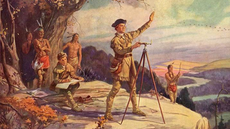
In 1754, a 22-year-old Washington marched into the wilderness surrounding Pittsburgh with more ambition than sense. He volunteered to travel to the Ohio Valley on a mission to deliver a letter from Robert Dinwiddie, governor of Virginia, to the commander of French troops in the Ohio territory. This military mission sparked an international war, cost him his first command and taught him lessons that would shape the American Revolution.
As a professor of early American history who has written two books on the American Revolution, I’ve learned that Washington’s time spent in the Fort Duquesne area taught him valuable lessons about frontier warfare, international diplomacy and personal resilience.
The mission to expel the French
In 1753, Dinwiddie decided to expel French fur trappers and military forces from the strategic confluence of three mighty waterways that crisscrossed the interior of the continent: the Allegheny, Monongahela and Ohio rivers. This confluence is where downtown Pittsburgh now stands, but at the time it was wilderness.
King George II authorized Dinwiddie to use force, if necessary, to secure lands that Virginia was claiming as its own.
As a major in the Virginia provincial militia, Washington wanted the assignment to deliver Dinwiddie’s demand that the French retreat. He believe the assignment would secure him a British army commission.
Washington received his marching orders on Oct. 31, 1753. He traveled to Fort Le Boeuf in northwestern Pennsylvania and returned a month later with a polite but firm “no” from the French.
Dinwiddie promoted Washington from major to lieutenant colonel and ordered him to return to the Ohio River Valley in April 1754 with 160 men. Washington quickly learned that French forces of about 500 men had already constructed the formidable Fort Duquesne at the forks of the Ohio. It was at this point that he faced his first major test as a military leader. Instead of falling back to gather more substantial reinforcements, he pushed forward. This decision reflected an aggressive, perhaps naive, brand of leadership characterized by a desire for action over caution.
Washington’s initial confidence was high. He famously wrote to his brother that there was “something charming” in the sound of whistling bullets.
The Jumonville affair and an international crisis
Perhaps the most controversial moment of Washington’s early leadership occurred on May 28, 1754, about 40 miles south of Fort Duquesne. Guided by the Seneca leader Tanacharison – known as the “Half King” – and 12 Seneca warriors, Washington and his detachment of 40 militiamen ambushed a party of 35 French Canadian militiamen led by Ensign Joseph Coulon de Jumonville. The Jumonville affair lasted only 15 minutes, but its repercussions were global.
Ten of the French, including Jumonville, were killed. Washington’s inability to control his Native American allies – the Seneca warriors executed Jumonville – exposed a critical gap in his early leadership. He lacked the ability to manage the volatile intercultural alliances necessary for frontier warfare.
Washington also allowed one enemy soldier to escape to warn Fort Duquesne. This skirmish effectively ignited the French and Indian War, and Washington found himself at the center of a burgeoning international crisis.
Defeat at Fort Necessity
Washington then made the fateful decision to dig in and call for reinforcements instead of retreating in the face of inevitable French retaliation. Reinforcements arrived: 200 Virginia militiamen and 100 British regulars. They brought news from Dinwiddie: congratulations on Washington’s victory and his promotion to colonel.
His inexperience showed in his design of Fort Necessity. He positioned the small, circular palisade in a meadow depression, where surrounding wooded high ground allowed enemy marksmen to fire down with impunity. Worse still, Tanacharison, disillusioned with Washington’s leadership and the British failure to follow through with promised support, had already departed with his warriors weeks earlier. When the French and their Native American allies finally attacked on July 3, heavy rains flooded the shallow trenches, soaking gunpowder and leaving Washington’s men vulnerable inside their poorly designed fortification.
The battle of Fort Necessity was a grueling, daylong engagement in the mud and rain. Approximately 700 French and Native American allies surrounded the combined force of 460 Virginian militiamen and British regulars. Despite being outnumbered and outmaneuvered, Washington maintained order among his demoralized troops. When French commander Louis Coulon de Villiers – Jumonville’s brother – offered a truce, Washington faced the most humbling moment of his young life: the necessity of surrender. His decision to capitulate was a pragmatic act of leadership that prioritized the survival of his men over personal honor.
The surrender also included a stinging lesson in the nuances of diplomacy. Because Washington could not read French, he signed a document that used the word “l’assassinat,” which translates to “assassination,” to describe Jumonville’s death. This inadvertent admission that he had ordered the assassination of a French diplomat became propaganda for the French, teaching Washington the vital importance of optics in international relations.
Lessons that forged a leader
The 1754 campaign ended in a full retreat to Virginia, and Washington resigned his commission shortly thereafter. Yet, this period was essential in transforming Washington from a man seeking personal glory into one who understood the weight of responsibility.
He learned that leadership required more than courage – it demanded understanding of terrain, cultural awareness of allies and enemies, and political acumen. The strategic importance of the Ohio River Valley, a gateway to the continental interior and vast fur-trading networks, made these lessons all the more significant.
Ultimately, the hard lessons Washington learned at the threshold of Fort Duquesne in 1754 provided the foundational experience for his later role as commander in chief of the Continental Army. The decisions he made in Pennsylvania and the Ohio wilderness, including the impulsive attack, the poor choice of defensive ground and the diplomatic oversight, were the very errors he would spend the rest of his military career correcting.
Though he did not capture Fort Duquesne in 1754, the young George Washington left the woods of Pennsylvania with a far more valuable prize: the tempered, resilient spirit of a leader who had learned from his mistakes.
Christopher Magra, Professor of American History, University of Tennessee
This article is republished from The Conversation under a Creative Commons license. Read the original article.
Dive into “The Knowledge,” where curiosity meets clarity. This playlist, in collaboration with STMDailyNews.com, is designed for viewers who value historical accuracy and insightful learning. Our short videos, ranging from 30 seconds to a minute and a half, make complex subjects easy to grasp in no time. Covering everything from historical events to contemporary processes and entertainment, “The Knowledge” bridges the past with the present. In a world where information is abundant yet often misused, our series aims to guide you through the noise, preserving vital knowledge and truths that shape our lives today. Perfect for curious minds eager to discover the ‘why’ and ‘how’ of everything around us. Subscribe and join in as we explore the facts that matter. https://stmdailynews.com/the-knowledge/
Author
Discover more from Daily News
Subscribe to get the latest posts sent to your email.


LOS ANGELES — Century Boulevard is one of the most recognizable east–west corridors in South Los Angeles, stretching from Watts to Los Angeles International Airport (LAX). But despite its grand-sounding name, the origin of “Century” is surprisingly simple—and rooted in math.
The Meaning Behind “Century”
Century Boulevard sits roughly 100 blocks south of downtown Los Angeles, where the city’s street numbering system begins at 1st Street and Main Street. Instead of naming the road “100th Street,” city planners opted for a more distinctive and memorable name: Century Boulevard.
In this case, “Century” literally means 100.
Part of Los Angeles’ Grid System
Los Angeles was designed using a grid-based street layout, especially in its expanding southern neighborhoods during the early 20th century. Streets were often named or numbered based on their distance from downtown.
Century Boulevard aligns with what would have been the 100th Street corridor—making it a key reference point in the city’s geography.
A Street That Evolved Over Time
Before it became Century Boulevard, portions of the roadway were known by other names, including Pine Avenue and San Antonio Street. As the region developed and expanded, these segments were unified under a single name in the 1920s.
This consolidation helped streamline navigation and supported growing transportation needs.
From Local Road to Global Gateway
The importance of Century Boulevard grew significantly with the rise of Los Angeles International Airport (LAX). Today, it serves as a major gateway for millions of travelers entering the city.
The road connects diverse communities—from historic neighborhoods in South Los Angeles to the bustling airport corridor—making it both a local lifeline and an international entry point.
More Than Just a Name
Century Boulevard reflects a broader pattern in Los Angeles street naming:
- Some streets honor historical figures
- Others reflect geography or culture
- And some, like Century, are rooted in the city’s structured grid system
It’s a reminder that even the most ordinary street names can reveal deeper stories about how a city was built.
The Bottom Line
Century Boulevard isn’t named after an event—it’s named for its location. Positioned at the 100th Street line, it represents both the logic of Los Angeles’ design and the growth of the city over time.
Now you know.
Related External Links
- Century Boulevard – Overview and History
- Los Angeles International Airport (LAX) – Official Website
- Los Angeles City Planning Department
- Los Angeles Public Library: The Story Behind LA Street Names
- LA Metro – Transportation System Information
- Calisphere – Historical Images and Maps of Los Angeles
Dive into “The Knowledge,” where curiosity meets clarity. This playlist, in collaboration with STMDailyNews.com, is designed for viewers who value historical accuracy and insightful learning. Our short videos, ranging from 30 seconds to a minute and a half, make complex subjects easy to grasp in no time. Covering everything from historical events to contemporary processes and entertainment, “The Knowledge” bridges the past with the present. In a world where information is abundant yet often misused, our series aims to guide you through the noise, preserving vital knowledge and truths that shape our lives today. Perfect for curious minds eager to discover the ‘why’ and ‘how’ of everything around us. Subscribe and join in as we explore the facts that matter. https://stmdailynews.com/the-knowledge/
Discover more from Daily News
Subscribe to get the latest posts sent to your email.
Forgotten Genius Fridays
Forgotten Genius Friday: The Gas Mask and the Man Who Invented It
Garrett Morgan, the inventor behind the modern gas mask and traffic signal, risked his life in 1916 to save workers trapped in a tunnel explosion beneath Cleveland. Though his invention worked and lives were saved, the media largely erased his name because he was Black. This is the story of a hero history tried to forget.
Last Updated on March 27, 2026 by Daily News Staff
🎥 The Knowledge – Episode: Garrett Morgan
“The man who gave us stoplights also saved lives underground.”
Before Garrett Morgan became known for inventing the three-position traffic signal, he was already changing the world—one breath at a time.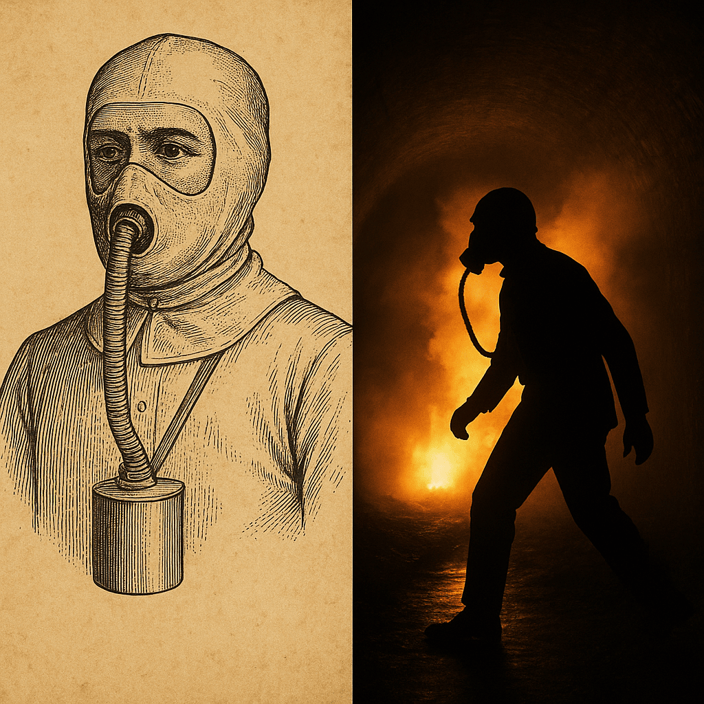
In 1912, Morgan designed a safety hood to protect firefighters and miners from the deadly smoke and toxic fumes they faced on the job. This early version of the gas mask featured breathing tubes and a wet sponge to filter air—simple, yet revolutionary.
But the true test came in 1916, when a natural gas explosion rocked a tunnel under Lake Erie in Cleveland. With little hesitation, Morgan donned his invention and entered the chaos. He saved multiple workers trapped beneath the earth—risking his own life to prove his device could do what others hadn’t even imagined.
Despite his heroism, headlines of the day often left out his name. Why? Because Garrett Morgan was Black. His contributions were buried in the shadows of racial prejudice, even as his inventions were saving lives and modernizing cities.
Today, we’re changing that narrative.
Garrett Morgan didn’t just invent the gas mask—he proved it worked. And his legacy deserves to breathe.
🧠 Now you know.
Related Links:
The Forgotten Genius Behind the Gas Mask – YouTube Short
Who Was Garrett Morgan? – Biography
More “Forgotten Genius Friday” Episodes
📢 Watch the full 60-second episode on our YouTube series, “The Knowledge,” and help us give credit where it’s due.
Author
Discover more from Daily News
Subscribe to get the latest posts sent to your email.
The Knowledge
Why Phoenix’s Skyline Has Stayed Low — And How It Compares to Los Angeles
Discover why Phoenix’s skyline lacks supertall skyscrapers, from FAA flight path limits near Phoenix Sky Harbor International Airport to how it compares with Los Angeles’s skyline growth.
Last Updated on March 25, 2026 by Daily News Staff
Phoenix is the fifth-largest city in the United States, yet its skyline doesn’t resemble other major metros like Los Angeles, Chicago, or Dallas. Despite rapid population and economic growth, downtown Phoenix has long lacked supertall skyscrapers — and until recently, didn’t even have a building tall enough to qualify as a true “skyscraper” under standard definitions.
The Basics: Phoenix’s Height Reality
The tallest structure in Phoenix for decades has been Chase Tower, rising to about 483 feet. Under the Council on Tall Buildings and Urban Habitat definition, a skyscraper reaches at least 492 feet — which means Phoenix has technically lacked one — despite its size and population.
A new project, the Astra Tower, is planned to rise around 540+ feet when it breaks ground, potentially giving Phoenix its first true skyscraper.
Airport Proximity: The FAA’s Height Grid
FAA Obstacle Evaluation & Downtown Limits
Phoenix’s skyline constraints are rooted in aviation safety.
📍 Phoenix Sky Harbor International Airport sits just a few miles from downtown.
- The Federal Aviation Administration (FAA) regulates building heights near airports so they don’t obstruct flight paths, require planes to alter approaches, or interfere with climb-out safety.
- In Phoenix, this results in a layered set of height limits that vary by location and elevation above sea level — often measured in feet above mean sea level (MSL) rather than simply building height from ground.
The city’s zoning code divides downtown into multiple contour zones with distinct maximum elevation values (e.g., 1,275 ft, 1,525 ft, 1,700 ft MSL), each tied to how close it sits under airport flight paths.
That means in some blocks you can’t build above a specific elevation even if ground levels are lower — a regulatory “roof” that varies across downtown.
City zoning also explicitly states that no building can exceed the FAA’s airport height limits, even if other bonuses or zoning allowances exist.
Phoenix vs. Los Angeles: A Quick Comparison
Los Angeles: Higher Limits, Different Constraints
Cities like Los Angeles also have nearby airports (e.g., Los Angeles International Airport), but their key business districts aren’t directly under major flight corridors.
LA’s downtown has:
- Taller office and residential towers
- A financial core with dense development
- Fewer FAA-driven overlays because the flight paths stretch past the downtown edge
Los Angeles’s tallest buildings — including Wilshire Grand Center (~1,100 ft) and U.S. Bank Tower (~1,018 ft) — were built where FAA restrictions don’t force low ceilings. FAA evaluations were conducted but didn’t cut as deeply into downtown zoning compared to Phoenix.
Phoenix, by contrast, sits right under approach and departure corridors — leading to consistent FAA involvement in almost every proposed mid- or high-rise downtown.
Economic and Planning Philosophies
Beyond FAA rules:
- Phoenix developed in the automobile era, with vast inexpensive land encouraging horizontal growth.
- Los Angeles grew earlier with heavier investment in centralized neighborhoods and higher density.
- Phoenix’s village plan long encouraged multiple smaller hubs instead of concentrating all growth in one downtown core.
These historical differences mean Phoenix didn’t have the same economic “pressure” to build up — even with zoning that allows significant height if FAA permits are met.
What This Means for Phoenix’s Future
Phoenix still has room to grow vertically — but:
- FAA height contours will remain the ceiling unless flight paths change
- Developers must secure determinations of no hazard from the FAA before going taller
- New projects like Astra show demand for taller buildings is rising
As Phoenix’s urban core densifies and land becomes scarcer, its skyline may yet reach higher — but always within the invisible grid drawn by aviation safety.
Related External Links
- Phoenix Sky Harbor International Airport Official Website
- FAA Obstruction Evaluation / Airport Airspace Analysis (OE/AAA)
- City of Phoenix Planning & Development Department
- Council on Tall Buildings and Urban Habitat (CTBUH)
- Los Angeles World Airports (LAX Authority)
- Phoenix Skyscraper Database & Diagrams
- Los Angeles Skyscraper Database & Diagrams
Dive into “The Knowledge,” where curiosity meets clarity. This playlist, in collaboration with STMDailyNews.com, is designed for viewers who value historical accuracy and insightful learning. Our short videos, ranging from 30 seconds to a minute and a half, make complex subjects easy to grasp in no time. Covering everything from historical events to contemporary processes and entertainment, “The Knowledge” bridges the past with the present. In a world where information is abundant yet often misused, our series aims to guide you through the noise, preserving vital knowledge and truths that shape our lives today. Perfect for curious minds eager to discover the ‘why’ and ‘how’ of everything around us. Subscribe and join in as we explore the facts that matter. https://stmdailynews.com/the-knowledge/
Discover more from Daily News
Subscribe to get the latest posts sent to your email.


