

News
Important Announcement: Scheduled Site Maintenance Tonight
Last Updated on February 17, 2025 by Daily News Staff
We want to keep you in the loop about an important update regarding our website. Tonight, we will be performing scheduled site maintenance to enhance our platform, improve user experience, and implement crucial updates.
What You Can Expect
During this maintenance window, there will be periods when our site may be temporarily inaccessible. We understand that this might cause some inconvenience, and we sincerely apologize for any disruption to your experience on our platform.
As part of this maintenance, please be advised that our affiliate advertisements will also be affected. During times when the site is offline, those advertisements will not be visible. This is a necessary step to ensure everything functions smoothly moving forward.
Why Are We Performing Maintenance?
Regular maintenance is essential for a number of reasons, including:
- Software Updates: We will be updating our backend systems to improve security and performance.
- Feature Enhancements: We’re excited to roll out new features based on your feedback to make navigation easier and more intuitive.
- Bug Fixes: We will address any bugs or issues to provide a seamless experience for you.
Maintenance Schedule
To keep disruption to a minimum, our maintenance will occur during the late evening hours. While we cannot provide an exact timeline, we will work diligently to complete the updates as quickly as possible. We appreciate your understanding if you encounter any downtime.
Stay Connected
If you have any questions or concerns during this maintenance period, please feel free to reach out to our customer support team. We are here to assist you in any way we can!
Thank You!
Thank you for your understanding and continued support! We are committed to providing you with the best experience possible and can’t wait for you to see the improvements we’ll be implementing. Please check back with us shortly after our maintenance window, and we’ll have everything up and running smoothly again!
Stay tuned, and we’ll be back online before you know it! 🌟
Author

The Knowledge
Artemis II’s long countdown – a space historian explains why it has taken over 50 years to return to the Moon
Why has it taken 50+ years to return to the Moon? A space historian explains the technical, political, and financial complexities behind Artemis II’s long journey.
Emily A. Margolis, Smithsonian Institution
While I was leading a tour of the National Air and Space Museum in January 2026, a visitor posed this insightful question: “Why has it taken so long to return to the Moon?”
After all, NASA had the know-how and technology to send humans to the lunar surface more than 50 years ago as part of the Apollo program. And, as another tour guest reminded us, computers today can do so much more than they could back then, as evidenced by the smartphones most of us carry in our pockets. Shouldn’t it be easier to get to the Moon than ever before?
The truth is that sending humans into space safely continues to be difficult, especially as missions increase in complexity.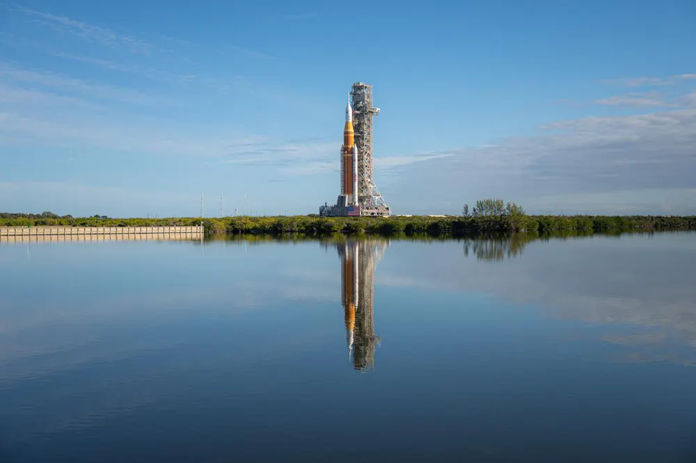
New technologies require years of study, development and testing before they can be certified for flight. And even then, systems and materials can behave in ways that surprise and worry engineers and mission planners; look no further than Boeing’s Starliner CFT mission or the performance of the Orion heat shield on Artemis I.
Issues with Starliner’s thrusters led NASA to return the spacecraft from the International Space Station without its crew. Unanticipated chipping of the Orion heat shield resulted in years of research, culminating in NASA altering the atmospheric reentry plans for the Artemis II mission.
NASA’s programs also require sustained political will and financial support across multiple presidential administrations, Congresses and fiscal years. As a historian of human spaceflight, I have studied the space agency’s efforts to engage the broader public to convince American taxpayers that their programs hold value for the nation.
NASA is now on the eve of the first crewed flight to the Moon since the Apollo era: Artemis II. A crew of four will conduct a lunar flyby, laying the groundwork, the agency hopes, for a landing on the Artemis IV mission.
The story of NASA’s effort to return humans to the Moon is long and winding, demonstrating the complexities of turning grand ambitions into real missions.
Post-Apollo
In early 1970, with two successful Moon landings on the books, President Richard Nixon sought to reduce NASA’s budget to better align with his administration’s priorities. This decision put the space agency in a difficult position, which ultimately led to the cancellation of three planned Apollo missions to conserve funding for its plans for long-term human activity in low Earth orbit.
NASA repurposed the third stage of a Saturn V rocket to create the first U.S. space station, Skylab, which operated from 1973 to 1974. The space agency used leftover Saturn IB rockets and Apollo command and service modules to send crews to the station.
Over the next three decades, NASA developed and operated the space shuttle. The fleet of space shuttle orbiters supported satellite deployment and microgravity research on orbital missions of up to 17 days. This work was meant to enable future long-duration human missions and provide benefits to people on Earth. For example, data from protein crystal growth experiments have informed the development of medicines.
The space shuttle program facilitated the construction, maintenance and staffing of a continuously inhabited research platform in orbit, the International Space Station. The first modules launched in late 1998.
Where to next?
As the new millennium approached, the Clinton administration tasked NASA to think beyond the space station. What could robots and humans do next in space? And where could they do it? Notably, the White House expressed an interest in locations beyond low Earth orbit.
NASA, it turned out, was well positioned to meet the administration’s request. NASA Administrator Daniel Goldin was already thinking about preparing proposals for the next presidential administration and had recently sponsored a human lunar return study. In 1999, he established a team to investigate new technologies, missions and destinations for the 21st century.
This work took on new significance following the tragic loss of the space shuttle Columbia crew in February 2003. Many people, including those in the new George W. Bush White House, wondered whether the human spaceflight program should continue – and, if so, how.
Administration discussions culminated in Bush’s Vision for Space Exploration in 2004, which directed NASA to retire the space shuttle after the completion of the space station. It called for returning humans to the Moon on a crew exploration vehicle designed for destinations beyond low Earth orbit.
It also called for continuing robotic exploration of Mars and engaging companies and international partners in space. Fifteen years earlier, President George H. W. Bush had also announced a Moon and Mars exploration program, but congressional concerns about cost kept space travelers close to home.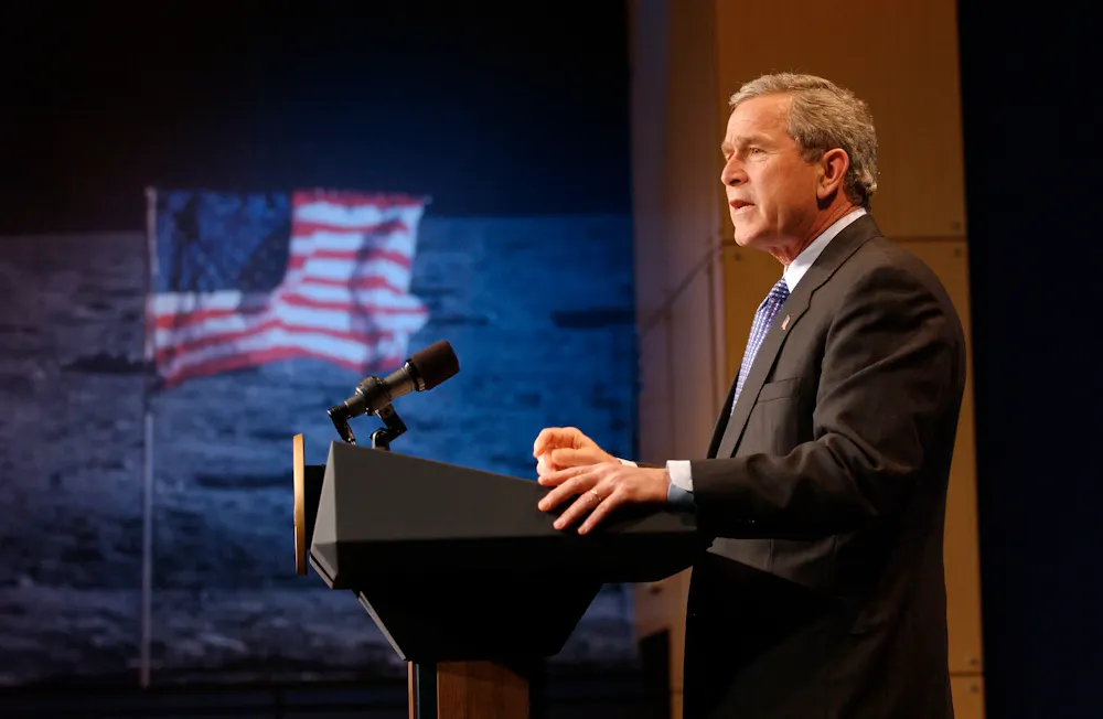
The Constellation program’s legacy
In December 2004, NASA began the process of finding a manufacturer for the crew exploration vehicle. By August 2006, the space agency awarded Lockheed Martin the contract to build the capsule, which it had named Orion – the same Orion planned to carry Artemis astronauts to the Moon.
Years of research, development and testing followed for Orion as well as the Ares I crew and Ares V cargo launch vehicles. Together, these technologies made up the Constellation program.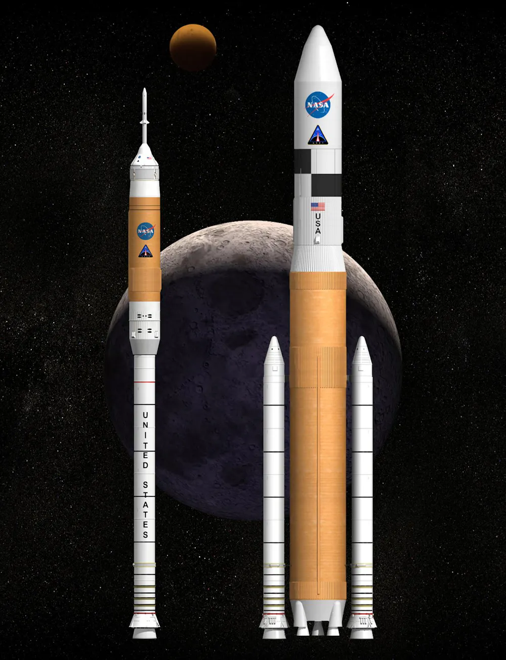
Constellation had two primary objectives: in the near term, to help transport crew to and from the space station after the space shuttle program ended; in the long term, to enable human lunar exploration.
Building systems that could work in both Earth orbit and around the Moon was supposed to save the time and cost of developing two vehicles. Similarly, adapting space shuttle program hardware could supposedly cut costs.
During the first months of Barack Obama’s presidency in 2009, the administration initiated an independent review of NASA’s human spaceflight plans. The Augustine Committee, chaired by retired aerospace executive Norman Augustine, found that the agency’s ambitions outstripped its limited budget, leading to significant delays. The first Orion spacecraft was likely to arrive after the space station ceased operations.
The committee proposed several paths forward at the current funding level, which prioritized space shuttle and space station programs. An additional annual investment of US$3 billion would allow for human exploration beyond low Earth orbit.
Ultimately, the Obama administration canceled Constellation, but two of its technologies lived on, thanks to U.S. senators from states that would have been affected by cuts.
The NASA Authorization Act of 2010 funded Orion’s continued development, shifting responsibility for space station crew transportation to commercial vehicles. It also directed NASA to develop the space launch system, a redesigned Ares V heavy booster, to send Orion to the Moon. The technical strategy had political benefits, too, preserving jobs in numerous congressional districts by providing continuity for aerospace contractors.
In December 2014, a Delta IV heavy rocket launched the first Orion capsule on a test flight, providing engineers with data on spacecraft systems and the heat shield. By October 2015, the space launch system had completed a critical design review, the last step before manufacturing could begin.
Introducing Artemis
In December 2017, the new Trump administration issued a policy directive shifting the focus of NASA’s human spaceflight program back to the Moon. The space agency would use Orion and the space launch system in a race to meet an ambitious 2024 landing date. NASA officially named the program Artemis in May 2019.
The 25-day Artemis I mission, launched in November 2022, was a major milestone for the program. This uncrewed flight was the first flight of the space launch system and the first to integrate SLS and Orion. It laid the groundwork for Artemis II, which will be the first crewed flight of the SLS.
Over more than 50 years, each new presidential administration has reassessed the place of spaceflight among its priorities, either encouraging or curtailing NASA’s efforts to return humans to the lunar surface.
Each crewed flight requires the alignment of technical expertise, political will and financial support over years if not decades. For the space fans who plan to watch the Artemis II launch, the wait for countdown may feel long. But it’s just a blink in NASA’s long journey back to the Moon.
Emily A. Margolis, Curator of Contemporary Spaceflight, National Air and Space Museum, Smithsonian Institution
This article is republished from The Conversation under a Creative Commons license. Read the original article.
Dive into “The Knowledge,” where curiosity meets clarity. This playlist, in collaboration with STMDailyNews.com, is designed for viewers who value historical accuracy and insightful learning. Our short videos, ranging from 30 seconds to a minute and a half, make complex subjects easy to grasp in no time. Covering everything from historical events to contemporary processes and entertainment, “The Knowledge” bridges the past with the present. In a world where information is abundant yet often misused, our series aims to guide you through the noise, preserving vital knowledge and truths that shape our lives today. Perfect for curious minds eager to discover the ‘why’ and ‘how’ of everything around us. Subscribe and join in as we explore the facts that matter. https://stmdailynews.com/the-knowledge/
Food and Beverage
Dirty Birds Expands to Downtown Long Beach, Signaling Continued Urban Revival
San Diego’s Dirty Birds sports bar is opening a new location in Downtown Long Beach, highlighting the city’s ongoing revitalization and growth ahead of the 2028 Olympics.

Downtown Long Beach is getting a flavorful new addition as The Bascom Group announces a lease agreement bringing San Diego’s popular sports bar chain Dirty Birds to a prime retail space at 200 Pine Avenue.
The deal marks another milestone in the ongoing revitalization of Long Beach, particularly within its bustling downtown entertainment corridor.
A Prime Location in the Heart of Downtown

The newly leased space spans 3,039 square feet on the ground floor of 200 Pine Avenue, a six-story office tower that has undergone significant renovations in recent years. The building, a recognizable fixture in the downtown skyline, includes:
- Class “A” upgraded common areas
- A 123-stall parking structure
- Strong tenant retention history
- Existing retail neighbors like Agaves Kitchen & Tequila and Agaves Ultra Lounge
An additional 4,923-square-foot lower-level space remains available and is already attracting interest for a potential speakeasy-style nightclub concept.
Dirty Birds Brings Its Signature Energy North
Founded in San Diego, Dirty Birds has built a loyal following as a high-energy sports bar known for:
- Award-winning chicken wings with unique flavors like Dirty Blue and Apple Bourbon Chipotle
- A lively, fan-focused atmosphere filled with sports memorabilia
- A diverse menu including burgers, sandwiches, salads, and craft beer
With multiple locations across San Diego neighborhoods like Pacific Beach, Ocean Beach, and near San Diego State University, the brand has established itself as a go-to destination for sports fans.
Its expansion into Long Beach represents a strategic move into a rapidly growing urban market.
Downtown Long Beach’s Ongoing Transformation
The arrival of Dirty Birds reflects broader momentum in downtown Long Beach, fueled by public and private investment. According to Bascom leadership, the area is experiencing a surge in activity driven by:
- Community events like the DTLB Live! series
- Streetscape and public space improvements
- Increased residential and mixed-use development
Nearby landmarks include:
- Billie Jean King Main Library
- Long Beach City Hall
- Long Beach Convention & Entertainment Center
The location also benefits from excellent transit access, including proximity to the Metro A Line.
Olympic Spotlight and Future Growth
Looking ahead, Long Beach is poised for global attention as a key venue city for the 2028 Summer Olympics. The city is expected to host 11 sporting events, making it one of the most active Olympic hubs outside Los Angeles itself.
This global spotlight is accelerating over $1.7 billion in development projects, including:
- Waterfront transformations
- Expanded residential housing
- Infrastructure upgrades through the Elevate 28 program
What This Means for Long Beach
The addition of Dirty Birds is more than just a new restaurant—it’s another indicator of a city on the rise. As downtown Long Beach continues to evolve into a vibrant live-work-play destination, high-profile tenants like Dirty Birds help:
- Strengthen the local economy
- Enhance nightlife and dining options
- Attract both residents and visitors
With an anticipated opening later this year, Dirty Birds is set to become a new hotspot for sports fans and food lovers alike.
Related Links
- 200 Pine Avenue Property Details
- LoopNet Listing for 200 Pine Avenue
- The Bascom Group Official Website
- Downtown Long Beach Plan
At our core, we at STM Daily News, strive to keep you informed and inspired with the freshest content on all things food and beverage. From mouthwatering recipes to intriguing articles, we’re here to satisfy your appetite for culinary knowledge.
Visit our Food & Drink section to get the latest on Foodie News and recipes, offering a delightful blend of culinary inspiration and gastronomic trends to elevate your dining experience. https://stmdailynews.com/food-and-drink/
Authors
Last Updated on April 7, 2026 by Daily News Staff
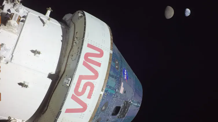
🕒 [UPDATE] Artemis II Reaches the Moon
Orion has reached lunar proximity, giving astronauts a historic view of the Moon as the spacecraft performs its flyby maneuver.

Artemis II Successfully Launches
CAPE CANAVERAL, Fla. — NASA has successfully launched its Artemis II mission, marking the first crewed journey toward the Moon in more than 50 years.
The powerful Space Launch System (SLS) rocket lifted off from Kennedy Space Center on April 1, carrying four astronauts on a 10-day mission around the Moon and back.
On board are Commander Reid Wiseman, Pilot Victor Glover, Mission Specialist Christina Koch, and Canadian astronaut Jeremy Hansen. The mission is already being hailed as a major milestone in NASA’s effort to return humans to deep space.
Shortly after liftoff, the Orion spacecraft successfully reached orbit and deployed its solar arrays, beginning its journey that will eventually send the crew on a translunar trajectory toward the Moon. 
Artemis II is a lunar flyby mission, meaning astronauts will not land but will travel farther from Earth than any human mission in decades while testing critical systems needed for future landings.
The mission also marks several historic firsts, including the first woman and the first person of color—Victor Glover—to travel into lunar space.
NASA says the mission is a key step toward future lunar landings and long-term plans to establish a human presence on the Moon later this decade.
🛰️ Artemis II Mission Timeline
The 10-day Artemis II mission follows a carefully planned trajectory from Earth to the Moon and back:
- Day 1: Launch and Earth orbit
- Day 1–2: Translunar injection burn
- Days 2–4: Deep space travel
- Days 4–5: Lunar flyby
- Days 5–8: Return to Earth
- Days 9–10: Reentry and splashdown
For official updates and in-depth mission details, visit the following trusted sources:
- NASA: Artemis II Mission Overview
- NASA Artemis Program (Return to the Moon)
- Orion Spacecraft – Mission Details
- Space Launch System (SLS) Rocket Overview
- Kennedy Space Center – Launch Operations
- Watch NASA Live Coverage and Replays
🧾 Sources
- NASA official launch coverage and mission updates
- NASA Artemis II press materials and briefings
- NASA Kennedy Space Center launch operations updates
Stay with STM Daily News for live updates on Artemis II.


