La Niña Weather Pattern to Disrupt Arizona Winter: What to Expect for 2024-2025
Arizona is expected to have a warmer, drier winter due to a developing La Niña, though uncertainty remains about precipitation levels, highlighting the complexity of weather patterns.
As we prepare for the winter months, the National Oceanic and Atmospheric Administration (NOAA) has released its forecast for the 2024-2025 winter season, and it looks like Arizona might be in for a significant change. According to meteorologists, the state is likely to experience a warmer and drier winter than usual due to the influence of a developing La Niña weather pattern.
Arizona may face a warmer, drier winter due to a developing La Niña, but there’s still a chance for wetter conditions. Stay informed! #LaNiña♬ original sound – STMDailyNews
Understanding La Niña
La Niña is a climate phenomenon that occurs in the Eastern Pacific Ocean. Typically, trade winds push warm surface waters toward Asia, but when these winds are stronger than normal, they lead to cooler ocean waters in the Eastern Pacific. This shift in ocean temperatures can have widespread effects on weather patterns across the United States.
In Arizona, La Niña usually correlates with above-normal temperatures and below-normal precipitation. This year, however, NOAA indicates that the La Niña phenomenon may be on the weaker side. While moderate to strong La Niña events are more likely to cause significant dry spells, the current weak La Niña means that the impacts may not be as pronounced.
Is Drier Always Drier?
It’s important to note that not every La Niña leads to a dry winter. According to the National Weather Service, there remains a 10% to 30% chance of experiencing wetter than normal conditions this winter. This uncertainty highlights the complexity of weather patterns and the need for ongoing monitoring and analysis.
Factors Influencing the Forecast
The official winter outlook takes into account various factors beyond La Niña, including the latest climate models and the broader context of climate change. These elements play a crucial role in shaping the weather we can expect in the coming months.
As we move closer to winter, it will be essential for residents and visitors in Arizona to stay informed about potential weather changes and be prepared for a season that might not follow the traditional patterns.
Preparing for the Winter
For those living in Arizona, it might be worth considering how a warmer, drier winter could affect your plans, from water conservation efforts to outdoor activities. Staying updated with NOAA and local weather forecasts will be crucial as we approach the winter months.
As winter approaches, it’s clear that La Niña will play a key role in shaping the weather across Arizona. While there is still some uncertainty regarding precipitation levels, one thing is for sure: it’s going to be an interesting season ahead.
The science section of our news blog STM Daily News provides readers with captivating and up-to-date information on the latest scientific discoveries, breakthroughs, and innovations across various fields. We offer engaging and accessible content, ensuring that readers with different levels of scientific knowledge can stay informed. Whether it’s exploring advancements in medicine, astronomy, technology, or environmental sciences, our science section strives to shed light on the intriguing world of scientific exploration and its profound impact on our daily lives. From thought-provoking articles to informative interviews with experts in the field, STM Daily News Science offers a harmonious blend of factual reporting, analysis, and exploration, making it a go-to source for science enthusiasts and curious minds alike. https://stmdailynews.com/category/science/
STM Daily News is a vibrant news blog dedicated to sharing the brighter side of human experiences. Emphasizing positive, uplifting stories, the site focuses on delivering inspiring, informative, and well-researched content. With a commitment to accurate, fair, and responsible journalism, STM Daily News aims to foster a community of readers passionate about positive change and engaged in meaningful conversations. Join the movement and explore stories that celebrate the positive impacts shaping our world.
Rod: A creative force, blending words, images, and flavors. Blogger, writer, filmmaker, and photographer. Cooking enthusiast with a sci-fi vision. Passionate about his upcoming series and dedicated to TNC Network. Partnered with Rebecca Washington for a shared journey of love and art. View all posts
Rod: A creative force, blending words, images, and flavors. Blogger, writer, filmmaker, and photographer. Cooking enthusiast with a sci-fi vision. Passionate about his upcoming series and dedicated to TNC Network. Partnered with Rebecca Washington for a shared journey of love and art.
A severe winter storm that brought crippling freezing rain, sleet and snow to a large part of the U.S. in late January 2026 left a mess in states from New Mexico to New England. Hundreds of thousands of people lost power across the South as ice pulled down tree branches and power lines, more than a foot of snow fell in parts of the Midwest and Northeast, and many states faced bitter cold that was expected to linger for days.
The sudden blast may have come as a shock to many Americans after a mostly mild start to winter, but that warmth may have partly contributed to the ferocity of the storm.
As atmospheric and climate scientists, we conduct research that aims to improve understanding of extreme weather, including what makes it more or less likely to occur and how climate change might or might not play a role.
To understand what Americans are experiencing with this winter blast, we need to look more than 20 miles above the surface of Earth, to the stratospheric polar vortex.On the morning of Jan. 26, 2026, the freezing line, shown in white, reached far into Texas. The light band with arrows indicates the jet stream, and the dark band indicates the stratospheric polar vortex. The jet stream is shown at about 3.5 miles above the surface, a typical height for tracking storm systems. The polar vortex is approximately 20 miles above the surface. Mathew Barlow, CC BY
What creates a severe winter storm like this?
Multiple weather factors have to come together to produce such a large and severe storm.
Winter storms typically develop where there are sharp temperature contrasts near the surface and a southward dip in the jet stream, the narrow band of fast-moving air that steers weather systems. If there is a substantial source of moisture, the storms can produce heavy rain or snow.
In late January, a strong Arctic air mass from the north was creating the temperature contrast with warmer air from the south. Multiple disturbances within the jet stream were acting together to create favorable conditions for precipitation, and the storm system was able to pull moisture from the very warm Gulf of Mexico.The National Weather Service issued severe storm warnings (pink) on Jan. 24, 2026, for a large swath of the U.S. that could see sleet and heavy snow over the following days, along with ice storm warnings (dark purple) in several states and extreme cold warnings (dark blue). National Weather Service
Where does the polar vortex come in?
The fastest winds of the jet stream occur just below the top of the troposphere, which is the lowest level of the atmosphere and ends about seven miles above Earth’s surface. Weather systems are capped at the top of the troposphere, because the atmosphere above it becomes very stable.
The stratosphere is the next layer up, from about seven miles to about 30 miles. While the stratosphere extends high above weather systems, it can still interact with them through atmospheric waves that move up and down in the atmosphere. These waves are similar to the waves in the jet stream that cause it to dip southward, but they move vertically instead of horizontally.A chart shows how temperatures in the lower layers of the atmosphere change between the troposphere and stratosphere. Miles are on the right, kilometers on the left. NOAA
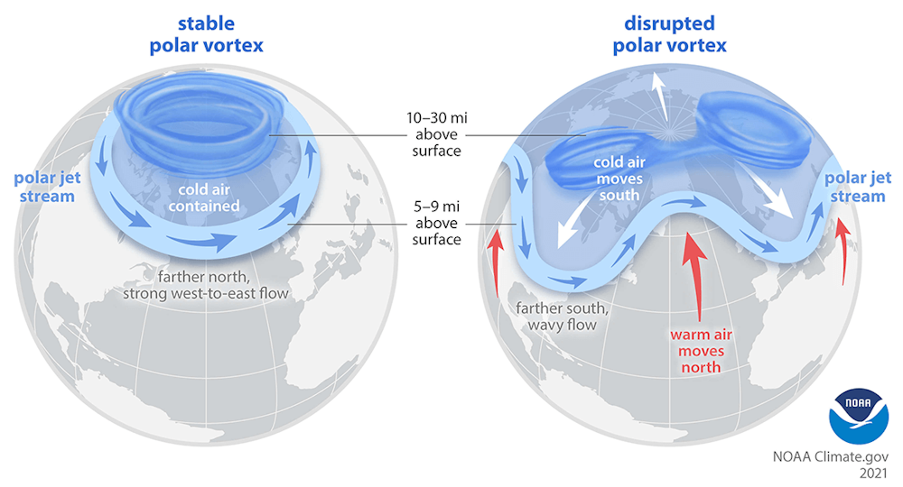
You’ve probably heard the term “polar vortex” used when an area of cold Arctic air moves far enough southward to influence the United States. That term describes air circulating around the pole, but it can refer to two different circulations, one in the troposphere and one in the stratosphere.
The Northern Hemisphere stratospheric polar vortex is a belt of fast-moving air circulating around the North Pole. It is like a second jet stream, high above the one you may be familiar with from weather graphics, and usually less wavy and closer to the pole.
Advertisement
Sometimes the stratospheric polar vortex can stretch southward over the United States. When that happens, it creates ideal conditions for the up-and-down movement of waves that connect the stratosphere with severe winter weather at the surface.A stretched stratospheric polar vortex reflects upward waves back down, left, which affects the jet stream and surface weather, right. Mathew Barlow and Judah Cohen, CC BY
The forecast for the January storm showed a close overlap between the southward stretch of the stratospheric polar vortex and the jet stream over the U.S., indicating perfect conditions for cold and snow.
This is what was happening in late January 2026 in the central and eastern U.S.
If the climate is warming, why are we still getting severe winter storms?
Earth is unequivocally warming as human activities release greenhouse gas emissions that trap heat in the atmosphere, and snow amounts are decreasing overall. But that does not mean severe winter weather will never happen again.
One factor may be increasing disruptions to the stratospheric polar vortex, which appear to be linked to the rapid warming of the Arctic with climate change.The polar vortex is a strong band of winds in the stratosphere, normally ringing the North Pole. When it weakens, it can split. The polar jet stream can mirror this upheaval, becoming weaker or wavy. At the surface, cold air is pushed southward in some locations. NOAA
Additionally, a warmer ocean leads to more evaporation, and because a warmer atmosphere can hold more moisture, that means more moisture is available for storms. The process of moisture condensing into rain or snow produces energy for storms as well. However, warming can also reduce the strength of storms by reducing temperature contrasts.
A warmer environment also increases the likelihood that precipitation that would have fallen as snow in previous winters may now be more likely to fall as sleet and freezing rain.
There are still many questions
Scientists are constantly improving the ability to predict and respond to these severe weather events, but there are many questions still to answer.
Much of the data and research in the field relies on a foundation of work by federal employees, including government labs like the National Center for Atmospheric Research, known as NCAR, which has been targeted by the Trump administration for funding cuts. These scientists help develop the crucial models, measuring instruments and data that scientists and forecasters everywhere depend on.
Advertisement
This article, originally published Jan. 24, 2026, has been updated with details from the weekend storm.
The science section of our news blog STM Daily News provides readers with captivating and up-to-date information on the latest scientific discoveries, breakthroughs, and innovations across various fields. We offer engaging and accessible content, ensuring that readers with different levels of scientific knowledge can stay informed. Whether it’s exploring advancements in medicine, astronomy, technology, or environmental sciences, our science section strives to shed light on the intriguing world of scientific exploration and its profound impact on our daily lives. From thought-provoking articles to informative interviews with experts in the field, STM Daily News Science offers a harmonious blend of factual reporting, analysis, and exploration, making it a go-to source for science enthusiasts and curious minds alike. https://stmdailynews.com/category/science/
What a bear attack in a remote valley in Nepal tells us about the problem of aging rural communities
A 71-year-old in Nepal’s Nubri valley survives repeated bear attacks as youth outmigration and rapid population aging leave fewer people to protect crops and homes—pushing bears closer to villages and raising urgent questions about safety, conservation rules, and rural resilience.
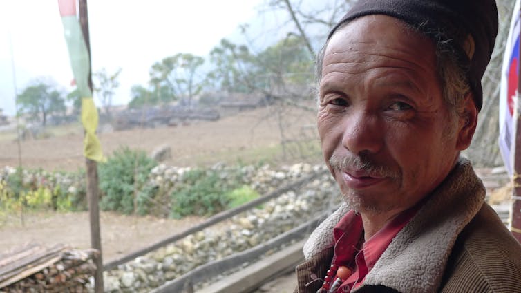
Dorje Dundul recently had his foot gnawed by a brown bear – a member of the species Ursus thibetanus, to be precise.
It wasn’t his first such encounter. Recounting the first of three such violent experiences over the past five years, Dorje told our research team: “My wife came home one evening and reported that a bear had eaten a lot of corn from the maize field behind our house. So, we decided to shoo it away. While my wife was setting up camp, I went to see how much the bear had eaten. The bear was just sitting there; it attacked me.”
Dorje dropped to the ground, but the bear ripped open his shirt and tore at his shoulder. “I started shouting and the bear ran away. My wife came, thinking I was messing with her, but when she saw the wounds, she knew what had happened.”
Researchers Dolma Choekyi Lama, Tsering Tinley and I spoke with Dorje – a 71-year-old resident of Nubri, a Buddhist enclave in the Nepalese highlands – as part of a three-year study of aging and migration.
Now, you may be forgiven for asking what a bear attack on a septuagenarian has to do with demographic change in Nepal. The answer, however, is everything.
In recent years, people across Nepal have witnessed an increase in bear attacks, a phenomenon recorded in news reports and academic studies.
Inhabitants of Nubri are at the forefront of this trend – and one of the main reasons is outmigration. People, especially young people, are leaving for education and employment opportunities elsewhere. It is depleting household labor forces, so much so that over 75% of those who were born in the valley and are now ages 5 to 19 have left and now live outside of Nubri.
It means that many older people, like Dorje and his wife, Tsewang, are left alone in their homes. Two of their daughters live abroad and one is in the capital, Kathmandu. Their only son runs a trekking lodge in another village.
Scarcity of ‘scarebears’
Until recently, when the corn was ripening, parents dispatched young people to the fields to light bonfires and bang pots all night to ward off bears. The lack of young people acting as deterrents, alongside the abandonment of outlying fields, is tempting bears to forage closer to human residences.
Outmigration in Nubri and similar villages is due in large part to a lack of educational and employment opportunities. The problems caused by the removal of younger people have been exacerbated by two other factors driving a rapidly aging population: People are living longer due to improvements in health care and sanitation; and fertility has declined since the early 2000s, from more than six to less than three births per woman.
Advertisement
These demographic forces have been accelerating population aging for some time, as illustrated by the population pyramid constructed from our 2012 household surveys in Nubri and neighboring Tsum.
A not-so-big surprise, anymore
Nepal is not alone in this phenomenon; similar dynamics are at play elsewhere in Asia. The New York Times reported in November 2025 that bear attacks are on the rise in Japan, too, partly driven by demographic trends. Farms there used to serve as a buffer zone, shielding urban residents from ursine intruders. However, rural depopulation is allowing bears to encroach on more densely populated areas, bringing safety concerns in conflict with conservation efforts.
Dorje can attest to those concerns. When we met him in 2023 he showed us deep claw marks running down his shoulder and arm, and he vowed to refrain from chasing away bears at night.
So in October 2025, Dorje and Tsewang harvested a field before marauding bears could get to it and hauled the corn to their courtyard for safekeeping. The courtyard is surrounded by stone walls piled high with firewood – not a fail-safe barrier but at least a deterrent. They covered the corn with a plastic tarp, and for extra measure Dorje decided to sleep on the veranda.
He described what happened next:
“I woke to a noise that sounded like ‘sharak, sharak.’ I thought it must be a bear rummaging under the plastic. Before I could do anything, the bear came up the stairs. When I shouted, it got frightened, roared and yanked at my mattress. Suddenly my foot was being pulled and I felt pain.”
Dorje suffered deep lacerations to his foot. Trained in traditional Tibetan medicine, he staunched the bleeding using, ironically, a tonic that contained bear liver.
Yet his life was still in danger due to the risk of infection. It took three days and an enormous expense by village standards – equivalent to roughly US$2,000 – before they could charter a helicopter to Kathmandu for further medical attention.
And Dorje is not the only victim. An elderly woman from another village bumped into a bear during a nocturnal excursion to her outhouse. It left her with a horrific slash from forehead to chin – and her son scrambling to find funds for her evacuation and treatment.A woman weeding freshly planted corn across the valley from Trok, Nubri. Geoff Childs, CC BY-SA
So how should Nepal’s highlanders respond to the increase in bear attacks?
Dorje explained that in the past they set lethal traps when bear encroachments became too dangerous. That option vanished with the creation of Manaslu Conservation Area Project, or MCAP, in the 1990s, a federal initiative to manage natural resources that strictly prohibits the killing of wild animals.
Advertisement
Learning to grin and bear it?
Dorje reasons that if MCAP temporarily relaxed the regulation, villagers could band together to cull the more hostile bears. He informed us that MCAP officials will hear nothing of that option, yet their solutions, such as solar-powered electric fencing, haven’t worked.
Dorje is reflective about the options he faces as young people leave the village, leaving older folk to battle the bears alone.
“At first, I felt that we should kill the bear. But the other side of my heart says, perhaps I did bad deeds in my past life, which is why the bear bit me. The bear came to eat corn, not to attack me. Killing it would just be another sinful act, creating a new cycle of cause and effect. So, why get angry about it?”
It remains to be seen how Nubri’s residents will respond to the mounting threats bears pose to their lives and livelihoods. But one thing is clear: For those who remain behind, the outmigration of younger residents is making the perils more imminent and the solutions more challenging.
Dolma Choekyi Lama and Tsering Tinley made significant contributions to this article. Both are research team members on the author’s project on population in an age of migration.
Moss Landing Battery Fire Fallout: Study Finds Toxic Metals Captured in Nearby Wetlands
After the January 2025 Moss Landing battery storage fire, researchers found nickel, manganese and cobalt particles raining onto nearby wetlands. A new study shows how toxic metals settled, spread with tides and rain, and may bioaccumulate through Elkhorn Slough’s food web—raising fresh questions about battery storage safety.
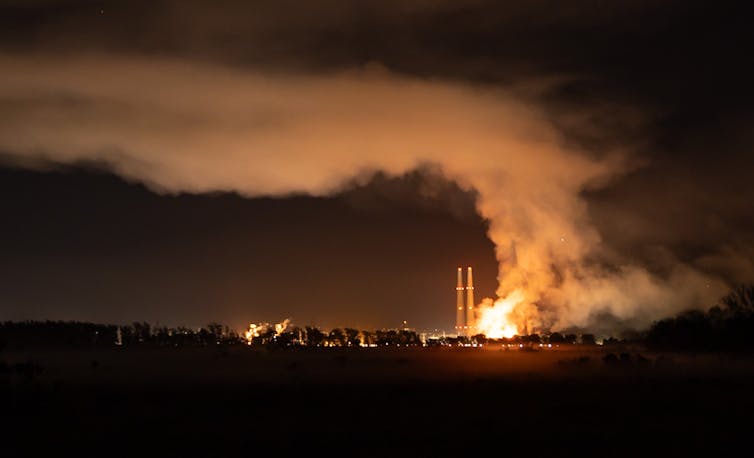
A battery energy storage facility that was built inside an old power plant burned from Jan. 16-18, 2025. Mike Takaki
Moss Landing Battery Fire Fallout: Study Finds Toxic Metals Captured in Nearby Wetlands
Ivano W. Aiello, San José State University When fire broke out at the world’s largest battery energy storage facility in January 2025, its thick smoke blanketed surrounding wetlands, farms and nearby communities on the central California coast. Highways closed, residents evacuated and firefighters could do little but watch as debris and ash rained down. People living in the area reported headaches and respiratory problems, and some pets and livestock fell ill. Two days later, officials announced that the air quality met federal safety standards. But the initial all-clear decision missed something important – heavy metal fallout on the ground.A chunk of charred battery debris found near bird tracks in the mud, with a putty knife to show the size. The surrounding marshes are popular stopovers for migrating seabirds. Scientists found a thin layer of much smaller debris across the wetlands.Ivano Aiello, et al, 2025 When battery energy storage facilities burn, the makeup of the chemical fallout can be a mystery for surrounding communities. Yet, these batteries often contain metals that are toxic to humans and wildlife. The smoke plume from the fire in Vistra’s battery energy storage facility at Moss Landing released not just hazardous gases such as hydrogen fluoride but also soot and charred fragments of burned batteries that landed for miles around. I am a marine geologist who has been tracking soil changes in marshes adjacent to the Vistra facility for over a decade as part of a wetland-restoration project. In a new study published in the journal Scientific Reports, my colleagues and I were able to show through detailed before-and-after samples from the marshes what was in the battery fire’s debris and what happened to the heavy metals. The batteries’ metal fragments, often too tiny to see with the naked eye, didn’t disappear. They continue to be remobilized in the environment today.The Vistra battery energy storage facility – the large gray building in the lower left, near Monterey Bay – is surrounded by farmland and marshes. The smoke plume from the fire rained ash on the area and reached four counties.Google Earth, with data from Google, Airbus, MBARI, CSUMB, CC BY
What’s inside the batteries
Moss Landing, at the edge of Monterey Bay, has long been shaped by industry – a mix of power generation and intensive agriculture on the edge of a delicate coastal ecosystem. The Vistra battery storage facility rose on the site of an old Duke Energy and PG&E gas power plant, which was once filled with turbines and oil tanks. When Vistra announced it was converting the site into the world’s largest lithium-ion battery facility, the plan was hailed as a clean energy milestone. Phase 1 alone housed batteries with 300 megawatts of capacity, enough to power about 225,000 homes for four hours. The energy in rechargeable batteries comes from the flow of electrons released by lithium atoms in the anode moving toward the cathode. In the type of batteries at the Moss Landing facility, the cathode was rich in three metals: nickel, manganese and cobalt. These batteries are prized for their high energy density and relatively low cost, but they are also prone to thermal runaway. Lab experiments have shown that burning batteries can eject metal particles like confetti.
Metals found in wetlands matched batteries
When my team and I returned to the marsh three days after the fire, ash and burned debris covered the ground. Weeks afterward, charred fragments still clung to the vegetation. Our measurements with portable X-ray fluorescence showed sharp increases in nickel, manganese and cobalt compared with data from before the fire. As soon as we saw the numbers, we alerted officials in four counties about the risk. We estimate that about 25 metric tons (55,000 pounds) of heavy metals were deposited across roughly half a square mile (1.2 square kilometers) of wetland around Elkorn Slough, and that was only part of the area that saw fallout. To put this in perspective, the part of the Vistra battery facility that burned was hosting 300 megawatts of batteries, which equates to roughly 1,900 metric tons of cathode material. Estimates of the amount of batteries that burned range from 55% to 80%. Based on those estimates, roughly 1,000 to 1,400 metric tons of cathode material could have been carried into the smoke plume. What we found in the marsh represents about 2% of what may have been released.These contour maps show how metals from the Moss Landing battery fire settled across nearby wetlands. Each color represents how much of a metal – nickel, manganese or cobalt – was found in surface soils. Darker colors mean higher concentrations. The highest levels were measured about two weeks after the fire, then declined as rain and tides dispersed the deposits.Charlie Endris We took samples at hundreds of locations and examined millimeter-thin soil slices with a scanning electron microscope. Those slices revealed metallic particles smaller than one-tenth the width of a human hair – small enough to travel long distances and lodge deep in the lungs. The ratio of nickel to cobalt in these particles matched that of nickel, manganese and cobalt battery cathodes, clearly linking the contamination to the fire. Over the following months, we found that surface concentrations of the metals dropped sharply after major rain and tidal events, but the metals did not disappear. They were remobilized. Some migrated to the main channel of the estuary and may have been flushed out into the ocean. Some of the metals that settled in the estuary could enter the food chain in this wildlife hot spot, often populated with sea otters, harbor seals, pelicans and herons.A high-magnification image of a leaf of bristly oxtongue, seen under a scanning electron microscope, shows a tiny metal particle typically used in cathode material in lithium-ion batteries, a stark reminder that much of the fallout from the fire landed on vegetation and croplands. The image’s scale is in microns: 1 micron is 0.001 millimeters.Ivano Aiello
Making battery storage safer as it expands
The fire at Moss Landing and its fallout hold lessons for other communities, first responders and the design of future lithium-ion battery systems, which are proliferating as utilities seek to balance renewable power and demand peaks. When fires break out, emergency responders need to know what they’re dealing with. A California law passed after the fire helps address this by requiring strengthening containment and monitoring at large battery installations and meetings with local fire officials before new facilities open.How lithium-ion batteries work, and why they can be prone to thermal runaway. Newer lithium-ion batteries that use iron phosphate cathodes are also considered safer from fire risk. These are becoming more common for utility-scale energy storage than batteries with nickel, manganese and cobalt, though they store less energy. How soil is tested is also important. At Moss Landing, some of the government’s sampling turned up low concentrations of the metals, likely because the samples came from broad, mixed layers that diluted the concentration of metals rather than the thin surface deposits where contaminants settled.
Continuing risks to marine life
Metals from the Moss Landing battery fire still linger in the region’s sediments and food webs. These metals bioaccumulate, building up through the food chain: The metals in marsh soils can be taken up by worms and small invertebrates, which are eaten by fish, crabs or shorebirds, and eventually by top predators such as sea otters or harbor seals. Our research group is now tracking the bioaccumulation in Elkhorn Slough’s shellfish, crabs and fish. Because uptake varies among species and seasons, the effect of the metals on ecosystems will take months or years to emerge. Ivano W. Aiello, Professor of Marine Geology, San José State University This article is republished from The Conversation under a Creative Commons license. Read the original article.