

The Knowledge
Why can’t it always be summer? It’s all about the Earth’s tilt
Earth’s axial tilt causes the seasons. As Earth orbits the Sun, different hemispheres tilt toward or away, creating summer and winter depending on location.
Last Updated on March 13, 2026 by Daily News Staff
Stephanie Spera, University of Richmond
Curious Kids is a series for children of all ages. If you have a question you’d like an expert to answer, send it to curiouskidsus@theconversation.com.
Why can’t it always be summer? – Amanda, age 5, Chile
With its long days just itching to be spent by water doing nothing, summer really can be an enchanting season. As Jenny Han wrote in the young adult novel “The Summer I Turned Pretty”: “Everything good, everything magical happens between the months of June and August.”
But all good things must come to an end, and summer cannot last forever. There’s both a simple reason and a more complicated one. The simple reason is that it can’t always be summer because the Earth is tilted. The more complicated answer requires some geometry.
I’m a professor of geography and the environment who has studied seasonal changes on the landscape. Here’s what seasons have to do with our planet’s position as it moves through the solar system.
This animation shows why the Earth has seasons.
Closeness to the Sun doesn’t explain seasons
First, you need to know that the Earth is a sphere – technically, an oblate spheroid. That means Earth has a round shape a little wider than it is tall.
Every year, Earth travels in its orbit to make one revolution around the Sun. The Earth’s orbit is an ellipse, which is more like an oval than a circle. So there are times when Earth is closer to the Sun and times when it’s farther away.
A lot of people assume this distance is why we have seasons. But these people would be wrong. In the United States, the Earth is 3 million miles closer to the Sun during winter than in the summer.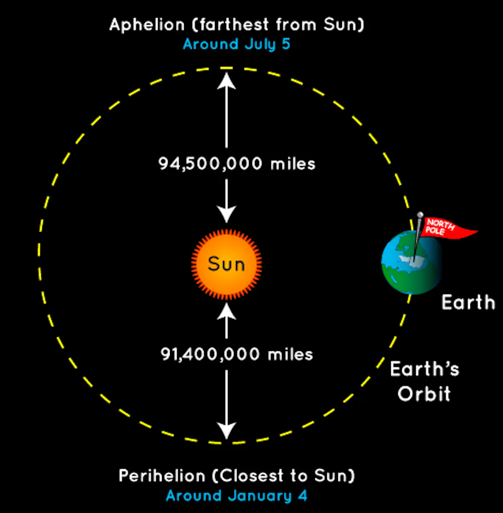
Spinning like a top
Now picture an imaginary line across Earth, right in the middle, at 0° latitude. This line is called the equator. If you drew it on a globe, the equator would pass through countries including Brazil, Kenya, Indonesia and Ecuador.
Everything north of the equator, including the United States, is considered the Northern Hemisphere, and everything south of the equator is the Southern Hemisphere.
Now think of the Earth’s axis as another imaginary line that runs vertically through the middle of the Earth, going from the North Pole to the South Pole.
As it orbits, or revolves, around the Sun, the Earth also rotates. That means it spins on its axis, like a top. The Earth takes one full year to revolve around the Sun and takes 24 hours, or one day, to do one full rotation on its axis.
This axis is why we have day and night; during the day, we’re facing the Sun, and at night, we’re facing away.
But the Earth’s axis does not go directly up and down. Instead, its axis is always tilted at 23.5 degrees in the exact same direction, toward the North Star.
The Earth’s axis is tilted due to a giant object – perhaps an ancient planet – smashing into it billions of years ago. And it’s this tilt that causes seasons.
It’s all about the tilt
So that means in June, the Northern Hemisphere is tilted toward the Sun. That tilt means more sunlight, more solar energy, longer days – all the things that make summer, well, summer.
At the same time, the Southern Hemisphere is tilted away from the Sun. So countries such as Australia, Chile and Argentina are experiencing winter then.
To say it another way: As the Earth moves around the Sun throughout the year, the parts of the Earth getting the most sunlight are always changing.
Fast-forward to December, and Earth is on the exact opposite side of its orbit as where it was in June. It’s the Southern Hemisphere’s turn to be tilted toward the Sun, which means its summer happens in December, January and February.
If Earth were not tilted at all, there would be no seasons. If it were tilted more than it is, there would be even more extreme seasons and drastic swings in temperature. Summers would be hotter and winters would be colder.
Defining summer
Talk to a meteorologist, climate scientist or author Jenny Han, and they’ll tell you that for those of us in the Northern Hemisphere, summer is June, July and August, the warmest months of the year.
But there’s another way to define summer. Talk to astronomers, and they’ll tell you the first day of summer is the summer solstice – the day of the year with the longest amount of daylight and shortest amount of darkness.
The summer solstice occurs every year sometime between June 20 and June 22. And every day after, until the winter solstice in December, the Northern Hemisphere receives a little less daylight.
Summer officially ends on the autumnal equinox, the fall day when everywhere on Earth has an equal amount of daylight and night. The autumnal equinox happens every year on either September 22 or 23.
But whether you view summer like Jenny Han or like an astronomer, one thing is certain: Either way, summer must come to an end. But the season and the magic it brings with it will be back before you know it.
Hello, curious kids! Do you have a question you’d like an expert to answer? Ask an adult to send your question to CuriousKidsUS@theconversation.com. Please tell us your name, age and the city where you live.
And since curiosity has no age limit – adults, let us know what you’re wondering, too. We won’t be able to answer every question, but we will do our best.
Stephanie Spera, Assistant Professor of Geography and the Environment, University of Richmond
This article is republished from The Conversation under a Creative Commons license. Read the original article.
The science section of our news blog STM Daily News provides readers with captivating and up-to-date information on the latest scientific discoveries, breakthroughs, and innovations across various fields. We offer engaging and accessible content, ensuring that readers with different levels of scientific knowledge can stay informed. Whether it’s exploring advancements in medicine, astronomy, technology, or environmental sciences, our science section strives to shed light on the intriguing world of scientific exploration and its profound impact on our daily lives. From thought-provoking articles to informative interviews with experts in the field, STM Daily News Science offers a harmonious blend of factual reporting, analysis, and exploration, making it a go-to source for science enthusiasts and curious minds alike. https://stmdailynews.com/category/science/
Dive into “The Knowledge,” where curiosity meets clarity. This playlist, in collaboration with STMDailyNews.com, is designed for viewers who value historical accuracy and insightful learning. Our short videos, ranging from 30 seconds to a minute and a half, make complex subjects easy to grasp in no time. Covering everything from historical events to contemporary processes and entertainment, “The Knowledge” bridges the past with the present. In a world where information is abundant yet often misused, our series aims to guide you through the noise, preserving vital knowledge and truths that shape our lives today. Perfect for curious minds eager to discover the ‘why’ and ‘how’ of everything around us. Subscribe and join in as we explore the facts that matter. https://stmdailynews.com/the-knowledge/


Last Updated on April 4, 2026 by Daily News Staff

Few transportation systems in the world are as instantly recognizable as the cable cars of San Francisco. Climbing steep hills with a steady hum and a nostalgic charm, these moving landmarks are more than just a tourist attraction—they’re a triumph of innovation born out of necessity.
🐎 A Problem on the Hills
In the mid-1800s, San Francisco was growing rapidly, but its geography posed a serious challenge. The city’s steep inclines made travel difficult, especially for horse-drawn streetcars, which were the primary form of public transportation at the time.
Horses often struggled to pull heavy loads uphill, and accidents were common. In some cases, animals collapsed under the strain. This dangerous and inefficient system needed a solution.
💡 The Vision of Andrew Hallidie
That solution came from Andrew Smith Hallidie, an engineer and entrepreneur who envisioned a safer, more reliable way to move people through the city.
Hallidie developed a system in which streetcars would be pulled by a continuously moving cable running beneath the street—eliminating the need for horses altogether.
⚙️ The First Cable Car Line
On August 2, 1873, Hallidie launched the world’s first cable car system: the Clay Street Hill Railroad.
This groundbreaking line proved that cable-powered transit could successfully navigate San Francisco’s steep terrain. Instead of relying on animal power, cars used a mechanical grip to latch onto a moving cable underground, allowing them to glide smoothly up and down hills.
The innovation quickly captured public attention—and demand.
🚀 A City Transformed
Following the success of the Clay Street line, cable car systems spread rapidly across San Francisco.
By the late 19th century:
- Dozens of routes crisscrossed the city
- Cable cars became the backbone of urban transportation
- The system helped shape the city’s growth and accessibility
For a time, San Francisco operated the largest and most advanced cable car network in the world.
⚡ The Rise of Electric Streetcars
Despite their success, cable cars faced competition from emerging electric streetcar systems in the early 20th century. Electric trolleys were cheaper to build and operate, and they didn’t require the complex underground cable infrastructure.
The turning point came after the devastating 1906 San Francisco earthquake, which destroyed much of the city—including large portions of the cable car network.
When rebuilding began, many lines were converted to electric systems instead of restoring the older cable technology.
San Francisco’s cable car system, first launched in 1873, remains the last manually operated system of its kind. According to the San Francisco Municipal Transportation Agency (SFMTA) , the system was designed to safely navigate the city’s steep terrain.
The cable cars are now designated as a National Historic Landmark, recognized for their cultural and engineering significance by the National Park Service .
Visitors can explore the history and mechanics of the system at the San Francisco Cable Car Museum , which preserves original equipment and archives.
🛑 Saving a Symbol
By the 1940s, cable cars were on the brink of extinction.
That’s when Friedel Klussmann stepped in. A passionate preservationist, Klussmann led a public campaign to protect the remaining lines from being dismantled.
Her efforts culminated in a successful 1947 voter referendum that ensured the survival of San Francisco’s cable cars—transforming them from everyday transit into a preserved cultural landmark.
🌉 Cable Cars Today
Today, San Francisco’s cable cars are:
- The last manually operated cable car system in the world
- A National Historic Landmark
- One of the most visited attractions in California
Three lines remain in operation:
- Powell–Hyde Line
- Powell–Mason Line
- California Street Line
While they still function as public transit, they now serve as a moving museum—connecting modern riders with the city’s past.
🎯 Why It Matters
San Francisco’s cable cars represent more than a mode of transportation. They tell a story of innovation, resilience, and community action.
From solving a practical problem to becoming a global icon, the cable car system reflects how cities adapt—and how people fight to preserve what makes them unique.
📌 “Now You Know”
San Francisco’s cable cars weren’t built for tourism—they were invented to solve a life-and-death problem on steep city streets. Today, they remain the last system of their kind anywhere in the world.
🔗 External Sources & Related Links
- SFMTA – Cable Cars Overview
- San Francisco Cable Car Museum
- National Park Service – Historic Landmark Info
- Britannica – Cable Car History
- History.com – Invention of Cable Cars
Explore the latest in innovation, AI, gadgets, startups, and digital trends in STM Daily News’ Techsection.
Last Updated on April 2, 2026 by Daily News Staff
🕒 [UPDATE] Orion Performs Translunar Injection Burn
The spacecraft has completed its critical engine burn, sending Artemis II on a trajectory toward the Moon. This marks the official start of its deep space journey.

Artemis II Successfully Launches
CAPE CANAVERAL, Fla. — NASA has successfully launched its Artemis II mission, marking the first crewed journey toward the Moon in more than 50 years.
The powerful Space Launch System (SLS) rocket lifted off from Kennedy Space Center on April 1, carrying four astronauts on a 10-day mission around the Moon and back.
On board are Commander Reid Wiseman, Pilot Victor Glover, Mission Specialist Christina Koch, and Canadian astronaut Jeremy Hansen. The mission is already being hailed as a major milestone in NASA’s effort to return humans to deep space.
Shortly after liftoff, the Orion spacecraft successfully reached orbit and deployed its solar arrays, beginning its journey that will eventually send the crew on a translunar trajectory toward the Moon. 
Artemis II is a lunar flyby mission, meaning astronauts will not land but will travel farther from Earth than any human mission in decades while testing critical systems needed for future landings.
The mission also marks several historic firsts, including the first woman and the first person of color—Victor Glover—to travel into lunar space.
NASA says the mission is a key step toward future lunar landings and long-term plans to establish a human presence on the Moon later this decade.
🛰️ Artemis II Mission Timeline
The 10-day Artemis II mission follows a carefully planned trajectory from Earth to the Moon and back:
- Day 1: Launch and Earth orbit
- Day 1–2: Translunar injection burn
- Days 2–4: Deep space travel
- Days 4–5: Lunar flyby
- Days 5–8: Return to Earth
- Days 9–10: Reentry and splashdown
For official updates and in-depth mission details, visit the following trusted sources:
- NASA: Artemis II Mission Overview
- NASA Artemis Program (Return to the Moon)
- Orion Spacecraft – Mission Details
- Space Launch System (SLS) Rocket Overview
- Kennedy Space Center – Launch Operations
- Watch NASA Live Coverage and Replays
🧾 Sources
- NASA official launch coverage and mission updates
- NASA Artemis II press materials and briefings
- NASA Kennedy Space Center launch operations updates
Stay with STM Daily News for live updates on Artemis II.

LOS ANGELES — Century Boulevard is one of the most recognizable east–west corridors in South Los Angeles, stretching from Watts to Los Angeles International Airport (LAX). But despite its grand-sounding name, the origin of “Century” is surprisingly simple—and rooted in math.
The Meaning Behind “Century”
Century Boulevard sits roughly 100 blocks south of downtown Los Angeles, where the city’s street numbering system begins at 1st Street and Main Street. Instead of naming the road “100th Street,” city planners opted for a more distinctive and memorable name: Century Boulevard.
In this case, “Century” literally means 100.
Part of Los Angeles’ Grid System
Los Angeles was designed using a grid-based street layout, especially in its expanding southern neighborhoods during the early 20th century. Streets were often named or numbered based on their distance from downtown.
Century Boulevard aligns with what would have been the 100th Street corridor—making it a key reference point in the city’s geography.
A Street That Evolved Over Time
Before it became Century Boulevard, portions of the roadway were known by other names, including Pine Avenue and San Antonio Street. As the region developed and expanded, these segments were unified under a single name in the 1920s.
This consolidation helped streamline navigation and supported growing transportation needs.
From Local Road to Global Gateway
The importance of Century Boulevard grew significantly with the rise of Los Angeles International Airport (LAX). Today, it serves as a major gateway for millions of travelers entering the city.
The road connects diverse communities—from historic neighborhoods in South Los Angeles to the bustling airport corridor—making it both a local lifeline and an international entry point.
More Than Just a Name
Century Boulevard reflects a broader pattern in Los Angeles street naming:
- Some streets honor historical figures
- Others reflect geography or culture
- And some, like Century, are rooted in the city’s structured grid system
It’s a reminder that even the most ordinary street names can reveal deeper stories about how a city was built.
The Bottom Line
Century Boulevard isn’t named after an event—it’s named for its location. Positioned at the 100th Street line, it represents both the logic of Los Angeles’ design and the growth of the city over time.
Now you know.
Related External Links
- Century Boulevard – Overview and History
- Los Angeles International Airport (LAX) – Official Website
- Los Angeles City Planning Department
- Los Angeles Public Library: The Story Behind LA Street Names
- LA Metro – Transportation System Information
- Calisphere – Historical Images and Maps of Los Angeles
Dive into “The Knowledge,” where curiosity meets clarity. This playlist, in collaboration with STMDailyNews.com, is designed for viewers who value historical accuracy and insightful learning. Our short videos, ranging from 30 seconds to a minute and a half, make complex subjects easy to grasp in no time. Covering everything from historical events to contemporary processes and entertainment, “The Knowledge” bridges the past with the present. In a world where information is abundant yet often misused, our series aims to guide you through the noise, preserving vital knowledge and truths that shape our lives today. Perfect for curious minds eager to discover the ‘why’ and ‘how’ of everything around us. Subscribe and join in as we explore the facts that matter. https://stmdailynews.com/the-knowledge/


