Connect with us

The Knowledge

Why two tiny mountain peaks became one of the internet’s most famous images

Two tiny mountain peaks: Ever wonder why a mountain icon appears when images won’t load? Discover the fascinating history behind the internet’s most ubiquitous placeholder symbol, from Japanese camera dials to Windows XP’s “Bliss” wallpaper, and why mountains represent mystery in digital life.

Published

on

Why two tiny mountain peaks became one of the internet’s most famous images
The icon has various iterations, but all convey the same meaning: an image should be here.
Christopher Schaberg, CC BY-SA

Why two tiny mountain peaks became one of the internet’s most famous images

Christopher Schaberg, Washington University in St. Louis

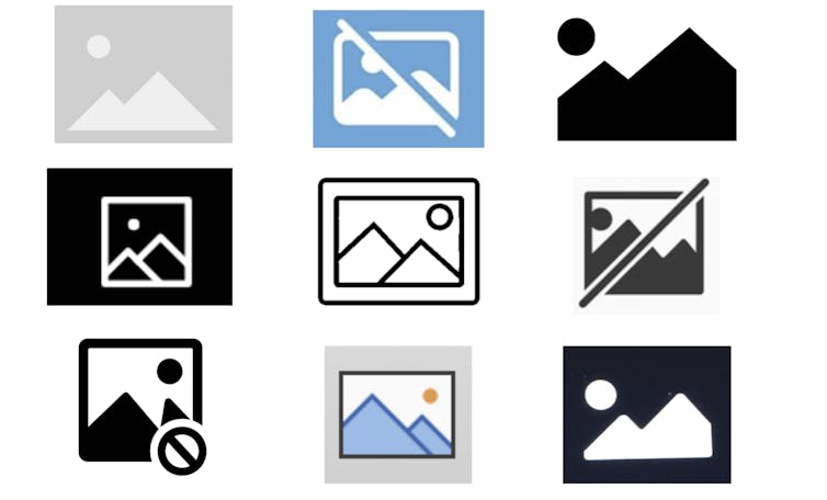
It’s happened to you countless times: You’re waiting for a website to load, only to see a box with a little mountain range where an image should be. It’s the placeholder icon for a “missing image.”

But have you ever wondered why this scene came to be universally adopted?

As a scholar of environmental humanities, I pay attention to how symbols of wilderness appear in everyday life.

The little mountain icon – sometimes with a sun or cloud in the background, other times crossed out or broken – has become the standard symbol, across digital platforms, to signal something missing or something to come. It appears in all sorts of contexts, and the more you look for this icon, the more you’ll see it.

You click on it in Microsoft Word or PowerPoint when you want to add a picture. You can purchase an ironic poster of the icon to put on your wall. The other morning, I even noticed a version of it in my Subaru’s infotainment display as a stand-in for a radio station logo.

So why this particular image of the mountain peaks? And where did it come from?

Arriving at the same solution

The placeholder icon can be thought of as a form of semiotic convergence, or when a symbol ends up meaning the same thing in a variety of contexts. For example, the magnifying glass is widely understood as “search,” while the image of a leaf means “eco-friendly.”

It’s also related to something called “convergent design evolution,” or when organisms or cultures – even if they have little or no contact – settle on a similar shape or solution for something.

In evolutionary biology, you can see convergent design evolution in bats, birds and insects, who all utilize wings but developed them in their own ways. Stilt houses emerged in various cultures across the globe as a way to build durable homes along shorelines and riverbanks. More recently, engineers in different parts of the world designed similar airplane fuselages independent of one another.

For whatever reason, the little mountain just worked across platforms to evoke open-ended meanings: Early web developers needed a simple shorthand way to present that something else should or could be there.

Advertisement
Get More From A Face Cleanser And Spa-like Massage

Depending on context, a little mountain might invite a user to insert a picture in a document; it might mean that an image is trying to load, or is being uploaded; or it could mean an image is missing or broken.

Down the rabbit hole on a mountain

But of the millions of possibilities, why a mountain?

In 1994, visual designer Marsh Chamberlain created a graphic featuring three colorful shapes as a stand-in for a missing image or broken link for the web browser Netscape Navigator. The shapes appeared on a piece of paper with a ripped corner. Though the paper with the rip will sometimes now appear with the mountain, it isn’t clear when the square, circle and triangle became a mountain.

A generic camera dial featuring various modes, with the 'landscape mode' – represented by two little mountain peaks – highlighted.
Two little mountain peaks are used to signal ‘landscape mode’ on many SLR cameras.
Althepal/Wikimedia Commons, CC BY

Users on Stack Exchange, a forum for developers, suggest that the mountain peak icon may trace back to the “landscape mode” icon on the dials of Japanese SLR cameras. It’s the feature that sets the aperture to maximize the depth of field so that both the foreground and background are in focus.

The landscape scene mode – visible on many digital cameras in the 1990s – was generically represented by two mountain peaks, with the idea that the camera user would intuitively know to use this setting outdoors.

Another insight emerged from the Stack Exchange discussion: The icon bears a resemblance to the Microsoft XP wallpaper called “Bliss.” If you had a PC in the years after 2001, you probably recall the rolling green hills with blue sky and wispy clouds.

The stock photo was taken by National Geographic photographer Charles O’Rear. It was then purchased by Bill Gates’ digital licensing company Corbis in 1998. The empty hillside in this picture became iconic through its adoption by Windows XP as its default desktop wallpaper image.
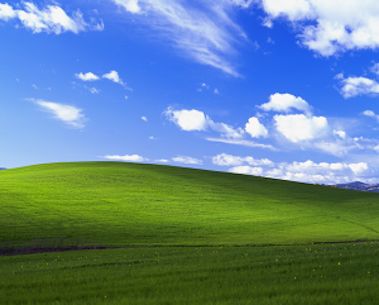
A colorful stock photo of green rolling hills, a blue sky and clouds.
If you used a PC at the turn of the 21st century, you probably encountered ‘Bliss.’
Wikimedia Commons

Mountain riddles

“Bliss” became widely understood as the most generic of generic stock photos, in the same way the placeholder icon became universally understood to mean “missing image.” And I don’t think it’s a coincidence that they both feature mountains or hills and a sky.

Mountains and skies are mysterious and full of possibilities, even if they remain beyond grasp.

Consider Japanese artist Hokusai’s “36 Views of Mount Fuji,” which were his series of paintings from the 1830s – the most famous of which is probably “The Great Wave off Kanagawa,” where a tiny Mount Fuji can be seen in the background. Each painting features the iconic mountain from different perspectives and is full of little details; all possess an ambiance of mystery.

A painting of a large rowboat manned by people on rolling waves with a large mountain in the background.
‘Tago Bay near Ejiri on the Tokaido,’ from Hokusai’s series ‘36 Views of Mount Fuji.’
Heritage Art/Heritage Images via Getty Images

I wouldn’t be surprised if the landscape icon on those Japanese camera dials emerged as a minimalist reference to Mount Fuji, Japan’s highest mountain. From some perspectives, Mount Fuji rises behind a smaller incline. And the Japanese photography company Fujifilm even borrowed the namesake of that mountain for their brand.

The enticing aesthetics of mountains also reminded me of the environmental writer Gary Snyder’s 1965 translation of Han Shan’s “Cold Mountain Poems.” Han Shan – his name literally means “Cold Mountain” – was a Chinese Buddhist poet who lived in the late eighth century. “Shan” translates as “mountain” and is represented by the Chinese character 山, which also resembles a mountain.

Han Shan’s poems, which are little riddles themselves, revel in the bewildering aspects of mountains:

Advertisement
Get More From A Face Cleanser And Spa-like Massage

Cold Mountain is a house
Without beams or walls.
The six doors left and right are open
The hall is a blue sky.
The rooms are all vacant and vague.
The east wall beats on the west wall
At the center nothing.

The mystery is the point

I think mountains serve as a universal representation of something unseen and longed for – whether it’s in a poem or on a sluggish internet browser – because people can see a mountain and wonder what might be there.

The placeholder icon does what mountains have done for millennia, serving as what the environmental philosopher Margret Grebowicz describes as an object of desire. To Grebowicz, mountains exist as places to behold, explore and sometimes conquer.

The placeholder icon’s inherent ambiguity is baked into its form: Mountains are often regarded as distant, foreboding places. At the same time, the little peaks appear in all sorts of mundane computing circumstances. The icon could even be a curious sign of how humans can’t help but be “nature-positive,” even when on computers or phones.

This small icon holds so much, and yet it can also paradoxically mean that there is nothing to see at all.

Viewing it this way, an example of semiotic convergence becomes a tiny allegory for digital life writ large: a wilderness of possibilities, with so much just out of reach.

Christopher Schaberg, Director of Public Scholarship, Washington University in St. Louis

This article is republished from The Conversation under a Creative Commons license. Read the original article.

Dive into “The Knowledge,” where curiosity meets clarity. This playlist, in collaboration with STMDailyNews.com, is designed for viewers who value historical accuracy and insightful learning. Our short videos, ranging from 30 seconds to a minute and a half, make complex subjects easy to grasp in no time. Covering everything from historical events to contemporary processes and entertainment, “The Knowledge” bridges the past with the present. In a world where information is abundant yet often misused, our series aims to guide you through the noise, preserving vital knowledge and truths that shape our lives today. Perfect for curious minds eager to discover the ‘why’ and ‘how’ of everything around us. Subscribe and join in as we explore the facts that matter.  https://stmdailynews.com/the-knowledge/

View recent photos

Unlock fun facts & lost history—get The Knowledge in your inbox!

We don’t spam! Read our privacy policy for more info.

Advertisement
Get More From A Face Cleanser And Spa-like Massage

Discover more from Daily News

Subscribe to get the latest posts sent to your email.

Continue Reading
Advertisement Sports Research
Click to comment

Leave a Reply

Your email address will not be published. Required fields are marked *

The Knowledge

Century City: From Hollywood Backlot to Business Hub

Century City, originally part of 20th Century Fox’s backlot, transformed into a prominent business district in Los Angeles during the 1950s amid the decline of cinema. Developer William Zeckendorf envisioned a mixed-use urban center, leading to iconic skyscrapers and establishing the area as a hub for law, finance, and media, blending Hollywood history with modern business.

Published

on

Before Century City became one of Los Angeles’ premier business districts, it was part of 20th Century Fox’s sprawling backlot, used for filming movies and housing studio operations. By the 1950s, as television rose and movie attendance declined, 20th Century Fox faced financial challenges and decided to sell a portion of its land.

Discover the origin of Century City, where 20th Century Fox’s historic backlot transformed into one of Los Angeles’ premier business districts. Explore how Hollywood history shaped LA’s modern skyline.
Traffic On 405 Freeway In LA With Century City In The Background

Developer William Zeckendorf envisioned a “city within a city”—a modern, mixed-use urban center with office towers, hotels, and entertainment facilities. Branded Century City, the name paid homage to its studio roots while symbolizing LA’s vision for the future.

The first skyscrapers, including the Gateway West Building, set the tone for the district’s sleek, futuristic skyline. Architects like Welton Becket and Minoru Yamasaki helped shape Century City’s iconic look. Over time, it evolved from Hollywood’s backlot to a corporate and legal hub, attracting law firms, financial institutions, and media companies.

Today, Century City stands as a testament to Los Angeles’ postwar optimism, westward expansion, and multi-centered urban growth—a unique blend of Hollywood history and modern business.


Related STM Daily News Links:

Dive into “The Knowledge,” where curiosity meets clarity. This playlist, in collaboration with STMDailyNews.com, is designed for viewers who value historical accuracy and insightful learning. Our short videos, ranging from 30 seconds to a minute and a half, make complex subjects easy to grasp in no time. Covering everything from historical events to contemporary processes and entertainment, “The Knowledge” bridges the past with the present. In a world where information is abundant yet often misused, our series aims to guide you through the noise, preserving vital knowledge and truths that shape our lives today. Perfect for curious minds eager to discover the ‘why’ and ‘how’ of everything around us. Subscribe and join in as we explore the facts that matter.  https://stmdailynews.com/the-knowledge/


Discover more from Daily News

Subscribe to get the latest posts sent to your email.

Continue Reading

The Knowledge

How a 22-year-old George Washington learned how to lead, from a series of mistakes in the Pennsylvania wilderness

This Presidents Day, I’ve been thinking about George Washington − not at his finest hour, but possibly at his worst.

Published

on

How a 22-year-old George Washington learned how to lead, from a series of mistakes in the Pennsylvania wilderness
A young George Washington was thrust into the dense, contested wilderness of the Ohio River Valley as a land surveyor for real estate development companies in Virginia. Henry Hintermeister/Public domain via Wikimedia Commons

Christopher Magra, University of Tennessee

This Presidents Day, I’ve been thinking about George Washington − not at his finest hour, but possibly at his worst.

In 1754, a 22-year-old Washington marched into the wilderness surrounding Pittsburgh with more ambition than sense. He volunteered to travel to the Ohio Valley on a mission to deliver a letter from Robert Dinwiddie, governor of Virginia, to the commander of French troops in the Ohio territory. This military mission sparked an international war, cost him his first command and taught him lessons that would shape the American Revolution.

As a professor of early American history who has written two books on the American Revolution, I’ve learned that Washington’s time spent in the Fort Duquesne area taught him valuable lessons about frontier warfare, international diplomacy and personal resilience.

The mission to expel the French

In 1753, Dinwiddie decided to expel French fur trappers and military forces from the strategic confluence of three mighty waterways that crisscrossed the interior of the continent: the Allegheny, Monongahela and Ohio rivers. This confluence is where downtown Pittsburgh now stands, but at the time it was wilderness.

King George II authorized Dinwiddie to use force, if necessary, to secure lands that Virginia was claiming as its own.

As a major in the Virginia provincial militia, Washington wanted the assignment to deliver Dinwiddie’s demand that the French retreat. He believe the assignment would secure him a British army commission.

Washington received his marching orders on Oct. 31, 1753. He traveled to Fort Le Boeuf in northwestern Pennsylvania and returned a month later with a polite but firm “no” from the French.

A close-up portrait of a young, brunette George Washington.
George Washington held an honorary commission as a major in the British army prior to the French and Indian War. Dea/M. Seemuller/De Agostini collection/Getty Images

Dinwiddie promoted Washington from major to lieutenant colonel and ordered him to return to the Ohio River Valley in April 1754 with 160 men. Washington quickly learned that French forces of about 500 men had already constructed the formidable Fort Duquesne at the forks of the Ohio. It was at this point that he faced his first major test as a military leader. Instead of falling back to gather more substantial reinforcements, he pushed forward. This decision reflected an aggressive, perhaps naive, brand of leadership characterized by a desire for action over caution.

Washington’s initial confidence was high. He famously wrote to his brother that there was “something charming” in the sound of whistling bullets.

The Jumonville affair and an international crisis

Perhaps the most controversial moment of Washington’s early leadership occurred on May 28, 1754, about 40 miles south of Fort Duquesne. Guided by the Seneca leader Tanacharison – known as the “Half King” – and 12 Seneca warriors, Washington and his detachment of 40 militiamen ambushed a party of 35 French Canadian militiamen led by Ensign Joseph Coulon de Jumonville. The Jumonville affair lasted only 15 minutes, but its repercussions were global.

A color illustration showing battle between soldiers in red and blue coats.
The Jumonville affair became the opening battle of the French and Indian War. Interim Archives/Archive Collection/Getty Images

Ten of the French, including Jumonville, were killed. Washington’s inability to control his Native American allies – the Seneca warriors executed Jumonville – exposed a critical gap in his early leadership. He lacked the ability to manage the volatile intercultural alliances necessary for frontier warfare.

Washington also allowed one enemy soldier to escape to warn Fort Duquesne. This skirmish effectively ignited the French and Indian War, and Washington found himself at the center of a burgeoning international crisis.

Advertisement
Get More From A Face Cleanser And Spa-like Massage

Defeat at Fort Necessity

Washington then made the fateful decision to dig in and call for reinforcements instead of retreating in the face of inevitable French retaliation. Reinforcements arrived: 200 Virginia militiamen and 100 British regulars. They brought news from Dinwiddie: congratulations on Washington’s victory and his promotion to colonel.

His inexperience showed in his design of Fort Necessity. He positioned the small, circular palisade in a meadow depression, where surrounding wooded high ground allowed enemy marksmen to fire down with impunity. Worse still, Tanacharison, disillusioned with Washington’s leadership and the British failure to follow through with promised support, had already departed with his warriors weeks earlier. When the French and their Native American allies finally attacked on July 3, heavy rains flooded the shallow trenches, soaking gunpowder and leaving Washington’s men vulnerable inside their poorly designed fortification.

A black and white illustration showing George Washington signing a document.
Washington was outnumbered and outmaneuvered at Fort Necessity. Interim Archives/Archive Collection/Getty Images

The battle of Fort Necessity was a grueling, daylong engagement in the mud and rain. Approximately 700 French and Native American allies surrounded the combined force of 460 Virginian militiamen and British regulars. Despite being outnumbered and outmaneuvered, Washington maintained order among his demoralized troops. When French commander Louis Coulon de Villiers – Jumonville’s brother – offered a truce, Washington faced the most humbling moment of his young life: the necessity of surrender. His decision to capitulate was a pragmatic act of leadership that prioritized the survival of his men over personal honor.

The surrender also included a stinging lesson in the nuances of diplomacy. Because Washington could not read French, he signed a document that used the word “l’assassinat,” which translates to “assassination,” to describe Jumonville’s death. This inadvertent admission that he had ordered the assassination of a French diplomat became propaganda for the French, teaching Washington the vital importance of optics in international relations.

A current photograph of the logs used to construct Fort Necessity as it stands today along the battlefield in Pennsylvania.
A log cabin used to protect the perishable supplies still stands at Fort Necessity today. MyLoupe/Universal Images Group/Getty Images

Lessons that forged a leader

The 1754 campaign ended in a full retreat to Virginia, and Washington resigned his commission shortly thereafter. Yet, this period was essential in transforming Washington from a man seeking personal glory into one who understood the weight of responsibility.

He learned that leadership required more than courage – it demanded understanding of terrain, cultural awareness of allies and enemies, and political acumen. The strategic importance of the Ohio River Valley, a gateway to the continental interior and vast fur-trading networks, made these lessons all the more significant.

Ultimately, the hard lessons Washington learned at the threshold of Fort Duquesne in 1754 provided the foundational experience for his later role as commander in chief of the Continental Army. The decisions he made in Pennsylvania and the Ohio wilderness, including the impulsive attack, the poor choice of defensive ground and the diplomatic oversight, were the very errors he would spend the rest of his military career correcting.

Though he did not capture Fort Duquesne in 1754, the young George Washington left the woods of Pennsylvania with a far more valuable prize: the tempered, resilient spirit of a leader who had learned from his mistakes.

Christopher Magra, Professor of American History, University of Tennessee

This article is republished from The Conversation under a Creative Commons license. Read the original article.

 
Dive into “The Knowledge,” where curiosity meets clarity. This playlist, in collaboration with STMDailyNews.com, is designed for viewers who value historical accuracy and insightful learning. Our short videos, ranging from 30 seconds to a minute and a half, make complex subjects easy to grasp in no time. Covering everything from historical events to contemporary processes and entertainment, “The Knowledge” bridges the past with the present. In a world where information is abundant yet often misused, our series aims to guide you through the noise, preserving vital knowledge and truths that shape our lives today. Perfect for curious minds eager to discover the ‘why’ and ‘how’ of everything around us. Subscribe and join in as we explore the facts that matter.  https://stmdailynews.com/the-knowledge/
 

Advertisement
Get More From A Face Cleanser And Spa-like Massage

Author


Discover more from Daily News

Subscribe to get the latest posts sent to your email.

Continue Reading

Urbanism

The Building That Proved Los Angeles Could Go Vertical

Los Angeles once banned skyscrapers, yet City Hall broke the height limit and proved high-rise buildings could be engineered safely in an earthquake zone.

Published

on

Los Angeles once banned skyscrapers, yet City Hall broke the height limit and proved high-rise buildings could be engineered safely in an earthquake zone.
LA City Hall. Image Credit: TNC Network & Envato

How City Hall Quietly Undermined LA’s Own Height Limits

The Knowledge Series | STM Daily News

For more than half a century, Los Angeles enforced one of the strictest building height limits in the United States. Beginning in 1905, most buildings were capped at 150 feet, shaping a city that grew outward rather than upward.

The goal was clear: avoid the congestion, shadows, and fire dangers associated with dense Eastern cities. Los Angeles sold itself as open, sunlit, and horizontal — a place where growth spread across land, not into the sky.

And yet, in 1928, Los Angeles City Hall rose to 454 feet, towering over the city like a contradiction in concrete.

It wasn’t built to spark a commercial skyscraper boom.
But it ended up proving that Los Angeles could safely build one.


A Rule Designed to Prevent a Manhattan-Style City

The original height restriction was rooted in early 20th-century fears:

  • Limited firefighting capabilities
  • Concerns over blocked sunlight and airflow
  • Anxiety about congestion and overcrowding
  • A strong desire not to resemble New York or Chicago

Los Angeles wanted prosperity — just not vertical density.

The height cap reinforced a development model where:

  • Office districts stayed low-rise
  • Growth moved outward
  • Automobiles became essential
  • Downtown never consolidated into a dense core

This philosophy held firm even as other American cities raced upward.


@stmblog

Los Angeles banned skyscrapers for decades — except one. 🏛️ While most buildings were capped at 150 feet, LA City Hall rose three times higher. This wasn’t a loophole — it was power, symbolism, and city planning shaping the skyline we know today. Why was City Hall the exception? And how did this one decision change Los Angeles forever? 📍 Forgotten LA 🧠 The Knowledge Series 📰 STM Daily News LosAngelesHistory LACityHall ForgottenLA UrbanPlanning CityPlanning LASkyline DidYouKnow HistoryTok TheKnowledge STMDailyNews ♬ original sound – STMDailyNews – STMDailyNews


Why City Hall Was Never Meant to Change the Rules

City Hall was intentionally exempt from the height limit because the law applied primarily to private commercial buildings, not civic monuments.

But city leaders were explicit about one thing:
City Hall was not a precedent.

It was designed to:

  • Serve as a symbolic seat of government
  • Stand alone as a civic landmark
  • Represent stability, authority, and modern governance
  • Avoid competing with private office buildings

In effect, Los Angeles wanted a skyline icon — without a skyline.


Innovation Hidden in Plain Sight

What made City Hall truly significant wasn’t just its height — it was how it was built.

Advertisement
Get More From A Face Cleanser And Spa-like Massage

At a time when seismic science was still developing, City Hall incorporated advanced structural ideas for its era:

  • A steel-frame skeleton designed for flexibility
  • Reinforced concrete shear walls for lateral strength
  • A tapered tower to reduce wind and seismic stress
  • Thick structural cores that distributed force instead of resisting it rigidly

These choices weren’t about aesthetics — they were about survival.


The Earthquake That Changed the Conversation

In 1933, the Long Beach earthquake struck Southern California, causing widespread damage and reshaping building codes statewide.

Los Angeles City Hall survived with minimal structural damage.

This moment quietly reshaped the debate:

  • A tall building had endured a major earthquake
  • Structural engineering had proven effective
  • Height alone was no longer the enemy — poor design was

City Hall didn’t just survive — it validated a new approach to vertical construction in seismic regions.


Proof Without Permission

Despite this success, Los Angeles did not rush to repeal its height limits.

Cultural resistance to density remained strong, and developers continued to build outward rather than upward. But the technical argument had already been settled.

City Hall stood as living proof that:

  • High-rise buildings could be engineered safely in Los Angeles
  • Earthquakes were a challenge, not a barrier
  • Fire, structural, and seismic risks could be managed

The height restriction was no longer about safety — it was about philosophy.


The Ironic Legacy

When Los Angeles finally lifted its height limit in 1957, the city did not suddenly erupt into skyscrapers. The habit of building outward was already deeply entrenched.

The result:

  • A skyline that arrived decades late
  • Uneven density across the region
  • Multiple business centers instead of one core
  • Housing and transit challenges baked into the city’s growth pattern

City Hall never triggered a skyscraper boom — but it quietly made one possible.


Why This Still Matters

Today, Los Angeles continues to wrestle with:

Advertisement
Get More From A Face Cleanser And Spa-like Massage
  • Housing shortages
  • Transit-oriented development debates
  • Height and zoning battles near rail corridors
  • Resistance to density in a growing city

These debates didn’t begin recently.

They trace back to a single contradiction: a city that banned tall buildings — while proving they could be built safely all along.

Los Angeles City Hall wasn’t just a monument.
It was a test case — and it passed.

Further Reading & Sources


More from The Knowledge Series on STM Daily News


Discover more from Daily News

Subscribe to get the latest posts sent to your email.

Continue Reading

Trending